Mt Pearse - 20th November 2021
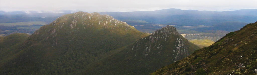
[The walk didn't go ahead due to lack of keen walkers - try again 2022!] Just off the Murchison Highway and half way between Waratah turnoff and the Belvoir Road (from Cradle Mt.), Mt. Pearse and Rocky Sugarloaf appear to stand out prominently, because of a stretch of relatively flat country around them, and on clear days, offer a great panorama in every direction. More experienced walkers who relish rough terrain and bands of scrub have completed a circuit of both in a day, but for this walk, Mt. Pearse will be the goal.
Walk Route:
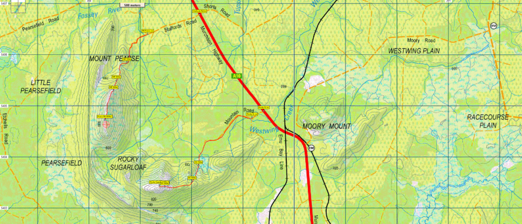
Leaving the cars at Staffords Rd, the route begins on an old vehicular track, then through a band of forest, heading southwest, then south for a few hundred metres. By now, the climbing begins, sidling the northern ridge of the mountain, and passing through bands of bauera scrub. There is a taped route, but sometimes, these can be hard to follow! Continuing west into a saddle, then south, the ridge to the summit climbs steeply, gaining 300 metres over a little more than 1 km, to reach the summit (alt. 1001m). Return to the cars via the same route. Rated medium due to the rough route and scrub, a good level of fitness is recommended for this walk. Energetic and resilient older children should be able to manage the conditions.
Meeting Times and Places:
If you are interested in going on this walk, please phone Darren Wunder on 0438 557 046 to book in. Meet 7:45 am at Hiscutt Park, Crescent Street Penguin by taking the right hand turn straight after the traffic lights if coming from Burnie or off the Bass Highway. A pond and windmill make it easy to spot.The alternative meeting place is Ridgely service station at 8:20 am (leave at 8:30). Please negotiate any alternative travel arrangements with the leader. You must contact the walk leader per details above if intending to join this walk. The leader should be notified of any other people you intend to bring along. Please be at any meeting place 5 minutes ahead of departure time.
To access Mt. Pearse from Burnie: Head south via Mount St and Ridgley Hwy/B18 to reach Ridgley, the alternative meeting place (12.5 km). From Ridgley, continue a further 42 km south along Ridgley Hwy to reach the Waratah junction. Continue south along the Murchison Hwy for 6.2 km to reach Staffords Rd. Turn right and continue for 1 km (gravel) to reach the start of the walk.
If coming from the Launceston area, the best alternative route is via Cradle Mt - Belvoir Rd, in which case, turn right when reaching the Murchison Hwy and head north 10.4 km to reach Staffords Rd.
Equipment and Warnings:
Bring sturdy shoes, wet/cold-weather gear, plenty of water, lunch and snacks. Gaiters would add comfort under the expected conditions.
The following codes [from our 2021 walks calendar] apply:
D Drive distance requires early departure – usually 7:30 am
E Exposed alpine conditions – can be dangerous in poor weather if not fully equipped – see below.
M Marshy or muddy sections – be prepared to walk with wet feet.
S Steep incline for at least part of the way
Click this link for a more detailed discussion of Preparation, Food and Safety guidelines for Boots N’ All walks
Map details: Mt Pearse and Rocky SL: 1:100000 map is Tasmap 8014 (Sophia) and 1:25000 map is 3840 (Pearse)
Map references:
Short ref.842046 for Pearse and 853033 for Rocky SL
………….. Zone Easting Northing Latitude Longitude
Pearse: 55G 3 84 310 54 04 720 -41.50079 145.61387
Rocky SL: 55G 3 85 370 54 03 440 -41.51247 145.62633
Mt.Pearse (alt. 1001 m) is worth 1 peakbagger point and Rocky SL (alt. 4974m) another 1 point. For listing of peakbagger points, see the Hobart Walking Club Peakbagger’s Guide (2000 revision) which can be downloaded (Excel) from http://tastracks.webs.com/peakbaggers.htm The same web page contains several other listings of Tasmanian peaks.
For GPX (.gpx) and Google Earth (.kml) versions of the track: Click here to browse our collection.
Direct links: GPX for this walk … KML for this walk
Right-click on the file and save target as to a location of your choice. (Suggest you click the Last modified at top to sort by date to get the most recent at top to find the file for the next walk).