Mt Wedge April 24
The advertised walk to Mt. Eliza had to be changed because the track to Mt. Eliza from Condominium Creek is still closed due to fire damage.
Mt. Wedge, 15 km to the northwest, is 130m lower in altitude, but still a great workout offering spectacular views.
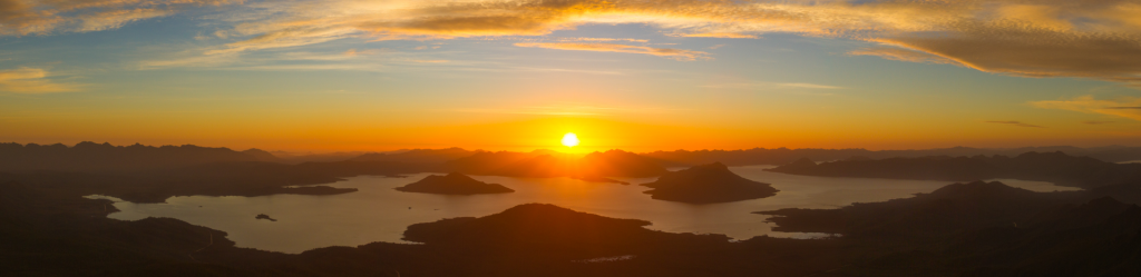
Mt Wedge sits in between Lake Pedder and Lake Gordon and has panoramic views towards a great many surrounding peaks including the Sentinels, Mt Anne, Mt Field West, the Franklands and the Western Arthurs, as well as Lake Pedder and Lake Gordon. It is a constant climb all the way and is great exercise!
The Route
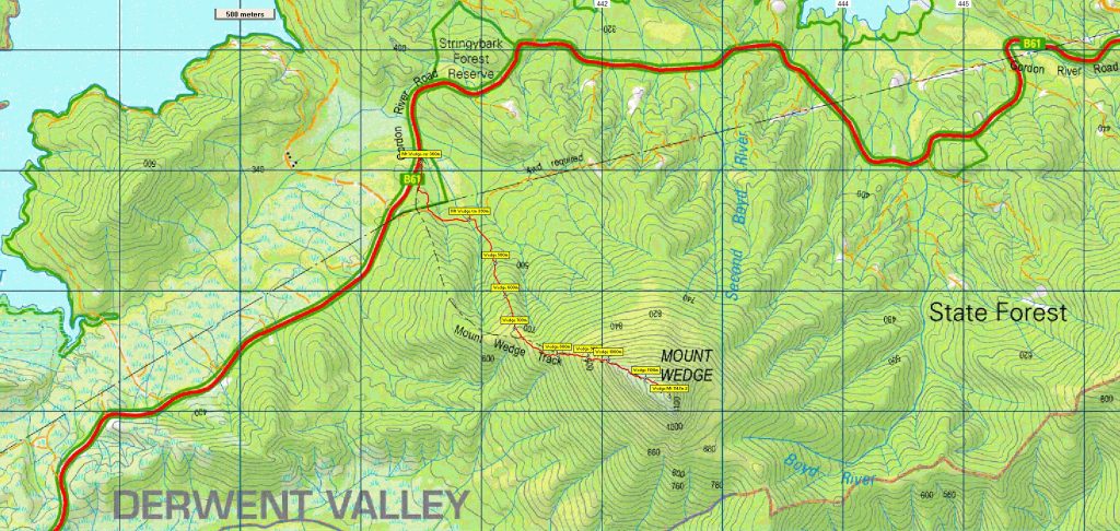
The track starts from a car park off Gordon Road about 12km past the Scotts Peak intersection - altitude 360m. It is a well signed car park and you can't miss it. The track starts on the Nature Walk circuit which has small signs along the way describing various vegetation. Part way around the circuit there's another track that is signed to Mt Wedge, 5hrs return. Take this track till it gets to the forestry road/fire trail. Take a left turn and walk for a few minutes along the road. On the right hand side of the road is the entrance to the Mt Wedge track. It is currently signed but the signs are degrading. The track itself is easy to see and once on the track it is well worn with plenty on reflective markers along the way.
Rising steeply and gaining 300 metres over the next km, the forest changes slightly as you head up and it's worth doing some tree spotting to keep yourself entertained on this section. The track then enters an overgrown area with long grasses, celery top pines and some candlestick richeas. After a short section of overgrown forest the view comes into sight and some alpine vegetation appears. The track rises even more steeply, gaining a further 400 metres over the next km. It's not far then to the rocky outcrop and the summit of Mt Wedge. A short scramble up the rocky area and the incline eases off. It is then a few minutes easy walking to the summit, altitude 1147m. The summit is quite flat but you don't have to walk far to get views in any direction. Total distance is 7 km return and 800m altitude each way. Fit adults and energetic and resilient older children should be able to manage this walk.
Meeting times and places
If you are interested in going on this walk, please phone Dan Hutchison on 0457765907 to book in, preferably by Thursday night, 22nd April. The departure time is 7:00 am from Citywide in Mornington, Hobart. Another Meeting point along the way could be Car park beside the Bridgewater Bridge roundabout on the Granton side at 7:30am. However, you still need to contact the walk leader per details above if intending to walk. The leader should be notified of any other people you intend to bring along. Please be at any meeting place 5 minutes ahead of departure time. Meeting at the Mt Wedge Carpark at 9am.
From Hobart, head north along the Brooker Highway, then the Lyell Highway through New Norfolk. Take the Gordon River Road from New Norfolk and follow it for 72km before coming to the Car park on the left-hand side of the road, roughly 12km past the Scott’s Peak intersection.
Warnings:
The following codes [from our 2021 walks calendar] apply:
B Boulder field – walkers need to be able to confidently step from rock to rock.
C Climbing sections using rocks and vegetation as hand holds.
D Drive distance requires early departure – usually 7:30 am
L A long day’s walk – in excess of 3 hours each way.
M Marshy or muddy sections be prepared to walk with wet feet.
E Exposed alpine conditions – can be dangerous in poor weather if not fully equipped.
Click this link for a more detailed discussion of Preparation, Food and Safety guidelines for Boots N’ All walks
Map details: Mt. Wedge: 1:100000 map is Tasmap 8112 (Wedge) and 1:25000 map is 4425 (Bowes)
Map references:
Short ref. 424559
Zone Easting Northing Latitude Longitude
55G 4 42 560 52 56 120 -42.84534 146.29705
Mt. Eliza (alt. 1289 m) is worth 2 peakbagger points. For listing of peakbagger points, see the Hobart Walking Club Peakbagger’s Guide (2000 revision) which can be downloaded (Excel) from http://tastracks.webs.com/peakbaggers.htm The same web page contains several other listings of Tasmanian peaks.
For GPX (.gpx) and Google Earth (.kml) versions of the track: Click here to browse our collection.
Direct links: GPX for this walk … KML for this walk
Right-click on the file and save target as to a location of your choice. (Suggest you click the Last modified at top to sort by date to get the most recent at top to find the file for the next walk).