South Arm Convict trail – Arms End Reserve – 2:00 pm Sunday 6 June
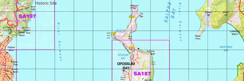
The South Arm Convict Trail runs from South Arm reserve through Opossum Bay and to Arm End. We will pick up the trail in the concluding section also known as the Arm End circuit, including the Arm End Lookout and Gellibrand's Vault. The walk takes 1.5 hours return as we move North from the Opossum Bay park, walking along the beach for a section (400m) and out to the Gellibrand Vault.
Dogs are welcome on a lead in the reserve but not on the beach and will take the alternative route along Spitfarm Road where we will all join to walk the last 500 metres to the start of Arm End Reserve. Here we will be following car tracks through a paddock (there are plans to develop the area, which we will see as we enter the reserve) to the lookout and then to the Gellibrand's Vault/tomb. This will be a walk for all ages and you are welcome to join us for BYO lunch before the walk at 1pm at the Opossum Bay Park.
Meeting Times and Places:
If you are interested in going on this walk, please phone your walk leader, Dan Hutchison, ph. 0457765907 or reply to this email by early Friday evening, 4th June, to book in. The departure time is 12:15 pm from the Citywide Baptist church car park, Mornington, for those that would also like to join us for BYO lunch before the walk at the Opossum Bay park and barbecue area at 1 pm. You are also welcome to meet us at the start of the walk, but please be there by 1:50 pm. Please let Dan know if you are meeting the group at start of walk. For this walk, you don’t need to let the leader know in advance if bringing other people, unless you need to arrange transport.
To access this area from Southern Tasmania: From Hobart, follow the South Arm Highway through Rokeby for about 32km. As you enter Opossum Bay and onto Spitfarm road the park will be on the left. You can continue on that road for 50 metres to a carpark with a toilet. Allow 40 minutes from Hobart to the start of the walk.
Warnings:
Please take note of the weather forecast on the day. No drinking water on the walk, so please bring your own, as well as a snack, and of course, your lunch if coming for the barbecue. Sensible footware is advised, but gaiters definitely not needed! You should always carry wet weather gear as well as warm clothing including gloves and beanies in case of sudden weather changes. This is a winter walk, and the weather can change rapidly.
Click this link for a more detailed discussion ofPreparation, Food and Safety guidelines for Boots N’ All walks.
Map details and references:
No peakbagger points will be visited on this walk. For listing of peakbagger points, see the Hobart Walking Club Peakbagger’s Guide (2000 revision) which can be downloaded (Excel) from http://tastracks.webs.com/peakbaggers.htm The same web page contains several other listings of Tasmanian peaks.For GPX (.gpx) and Google Earth (.kml) versions of the track: Click here to browse our collection.
Direct links: GPX for this walk … KML for this walk The track file for this walk, courtesy of Hiking Southeast Tasmania website, may not be exactly followed.
Right-click on the file and save target as to a location of your choice. (Suggest you click the Last modified at top to sort by date to get the most recent at top to find the file for the next walk).