Rattler Hill and Star of Peace Rainforest - Sat. 26th June 2021
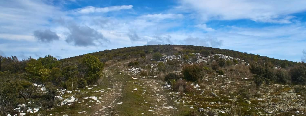
Rattler Hill is a prominent hill in the northeast of Tasmania and the nearby Star of Peace Rainforest is a beautiful old growth forest well worth visiting. This will be a first for Boots 'n' All as we explore some interesting parts of northeast Tasmania's highland forests.
The walk is about 10 km in length and should take about 5-6 hours in total including breaks. More than half of it is along a road and is mostly easy walking, although part involves a steep descent, and there are also some waterlogged sections of the road at present, after all the recent heavy rain in the northeast, so some hopping around pools and puddles will be needed. The rest of the walk is on a taped route through the forest and will involve stepping over and around vegetation at times, with some muddy sections. Therefore good boots and preferably gaiters would be an advantage. It could be very dark in the thick forest later in the afternoon if we have a dull day, so it would be good to bring a head torch as well. This walk is rated medium and energetic able older children should be able to manage it.
Walk route:
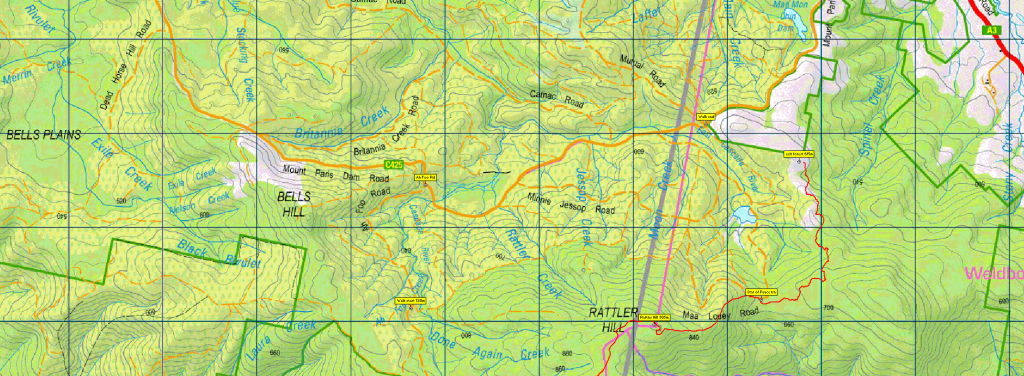
The walk starts at about 750 m altitude on the Ah Foo Road, a branch of the Mt Paris Dam Road, near Branxholm in NE Tasmania. After first dropping a vehicle at the other end of the walk, we will proceed on foot along a rough 4WD track initially in a generally easterly direction for about 4 km to the top of Rattler Hill, climbing about 150 m in the process. This should take about one and a half hours. There we will enjoy good views of the northeast if the weather is clear. Then we follow the road onwards downhill for about 2 km, descending about 200m in the process, and quite steeply towards the end. This should take about an hour. At this point we will leave the road and follow a taped track through beautiful rainforest. This will be about 4 km, losing another 100m in height with some undulations, taking about 3 hours including breaks - we will stop for lunch at a nice open spot in the rainforest. Once we reach the end of this section we will conclude the walk as we will be at the end of a drivable road that goes on to join the Mt Paris Dam Road near the Ma Mon Chin Dam. We will wait here while the drivers go back to retrieve the vehicles from the start point..
Meeting Times and Places:
If you are interested in joining this walk, please phone, text or email the leader, Phil Andrew, on 6300 1067, 0408 014 757, or pandrew.tas@gmail.com. The departure time is 7:30 am from Door of Hope carpark in South Launceston. If you would like to arrange to meet elsewhere, please arrange with the leader, and please be at any meeting place 5 minutes ahead of the listed time. The leader must be notified of any other people you intend to bring along.
To access this area from northern Tasmania:
From Launceston, head towards Scottsdale either on the Tasman Highway, or via Lilydale if you prefer, and continue through Scottsdale and then out of town along the Tasman Highway southeast towards the East Coast. After travelling 25km you will reach the town of Branxholm. Continue through this town for 1.6 km until you reach the Mt Paris Dam Road turn off to the right. Follow this for 11.2 km until you reach the Ah Foo Road turn off to the right. Follow this as far as possible, probably 2-3 km, to the start of the walk.
Warnings:
D... Drive distance requires early departure
M... Marshy or muddy sections – be prepared to walk with wet feet.
S... Steep incline (actually decline) for at least part of the way
You should carry wet weather gear as well as warm clothing in case of sudden weather changes. Walkers should carry water with them in case we don't find drinkable water en route - suggest 1 litre. Also bring your lunch and snacks.
Click this link for a more detailed discussion of Preparation, Food and Safety guidelines for Boots N' All walks.
Map details:
(to be added soon)
No peakbagger points will be visited on this walk. For listing of peakbagger points, see the Hobart Walking Club Peakbagger’s Guide (2000 revision) which can be downloaded (Excel) from http://tastracks.webs.com/peakbaggers.htm The same web page contains several other listings of Tasmanian peaks.For GPX (.gpx) and Google Earth (.kml) versions of the track: Click here to browse our collection.
Direct links: GPX for this walk … KML for this walk
Right-click on the file and save target as to a location of your choice. (Suggest you click the Last modified at top to sort by date to get the most recent at top to find the file for the next walk).