Waterfalls of the Northwest and West - Sat. 10th July
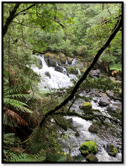
Starting and Finishing in Burnie, this tour of waterfalls covers the northwest and west coast areas. Drive and explore - highways, backroads, even a little bit of gravel road (well maintained). Five waterfalls, from really tall to quite small, deep in the bush and right next to the road, well known, or hidden and forgotten. Waratah, historic middle of town, Philosopher’s Falls, spectacular in the middle of the wilderness, Wandle, a beautiful little hidden gem, Cam, forgotten on the side of the road, and Guide Falls, well known, great access, always a pleasure to visit. We will meet in Burnie and share car seats where we can.
Actual walk times add up to about 2 hours. The walks involve lots of steps and mostly good/ easy tracks, except Wandle Falls which includes ½ km unformed track) and the chance of leeches. About 170 km of driving is involved (apart from getting to the meeting places at start of the day), and all sealed apart from 15-20 km of good gravel road.
Walk Locations and Times:
- 8.10 am Depart for Waratah via Ridgley Highway, 61 km, 47 minutes
- 9 am Waratah: meet Smith Street, between Town Hall and Council Chambers, toilets
- 9.15 am (1) Waratah Falls, 400m walk to base of falls.
- 10 am Drive to Philosophers Falls, 12 km, 12 minutes
- 10.15 am (2) Philosopher Falls, walk, 3 Km, (includes 211 steps) 1½ hours needed.
- 12.00 pm Return to Waratah, lunch at English St Park. (just past Police Station) 12 km, 12 minutes
- 12.15 – 12.45 Lunch, then drive to Wandle River, 17 km, 15 minutes.
- 12.45 pm (3) Wandle Falls, 30 minute,
- 1.15 pm, drive to Hellyer Gorge, and toilets, 15 minute, river walk (option) 1.5 km, 15 min.
- 1.45 pm, drive to cnr Douglas Road and Oonah Road. 20 km, 22 minutes.
- 2.10 pm, (4) Cam Falls, Oonah Road, just past Douglas Road, on the East Cam River
- 2.30 pm, drive to Guide falls, following Oonah Road, Guide Road, West Ridgley Road, 20 km, 23 minutes
- 3.00 pm (5) Guide Falls, Guide River, West Ridgley Road.
- 3.30 pm return to Burnie via West Ridgley Road, Ridgley Highway, Mount Street. 17km, 20 minutes.
- 4.00 pm Burnie
Meeting Times and Places:
If you are interested in going on this walk, please phone your walk leader, James Todd, ph. 0439 950 965 or email james.todd@su.org.au by early Friday evening, 9th July, to book in. Because of the number of places being visited, you should definitely let James know you are coming, and where you will meet him.
* 7.30 am Meet at Hiscutt Park Penguin. Crescent Street, Depart 7.40 am
* 8 am Meet at McDonalds Carpark Burnie. Cnr Bass Highway and Wilson Street. We may leave some cars there, and car pool to share the experience.
If you would like to arrange to meet elsewhere, please arrange with the leader, and please be at any meeting place 5 minutes ahead of the listed time.
To access this area from northern Tasmania:
See meeting places above... If coming from the Devonport area, allow 30 min for the 47 km trip. From Launceston, allow 1 hour 40 min for the 146 km trip (both following Bass Hwy). Allow approx. 1 hour for the 85 km trip if coming from the Smithton area.
Warnings:
D… Drive distance requires early departure
S… Steep incline (actually decline) for at least part of the way
A short section of un-tracked walk at Wandle Falls and some steep inclines with plenty of steps.
Being winter, you should definitely carry wet weather gear as well as warm clothing in case of sudden weather changes. You should carry some drinking water, and bring your lunch and snacks.
Click this link for a more detailed discussion of Preparation, Food and Safety guidelines for Boots N’ All walks.
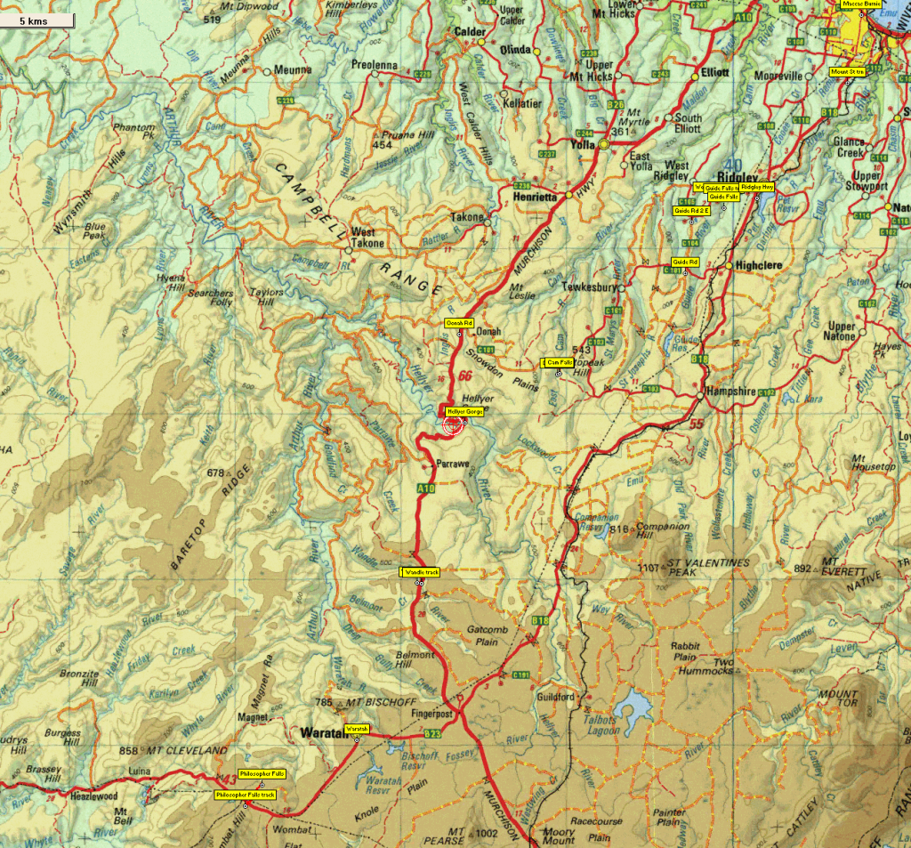
Map details:
No peakbagger points will be visited on this walk. For listing of peakbagger points, see the Hobart Walking Club Peakbagger’s Guide (2000 revision) which can be downloaded (Excel) from http://tastracks.webs.com/peakbaggers.htm The same web page contains several other listings of Tasmanian peaks.For GPX (.gpx) and Google Earth (.kml) versions of the track: Click here to browse our collection.
Direct links: GPX for this walk … KML for this walk (mainly waypoints for road, track and waterfall locations)
Right-click on the file and save target as to a location of your choice. (Suggest you click the Last modified at top to sort by date to get the most recent at top to find the file for the next walk).