Cape Raoul, Saturday 5th September 2021
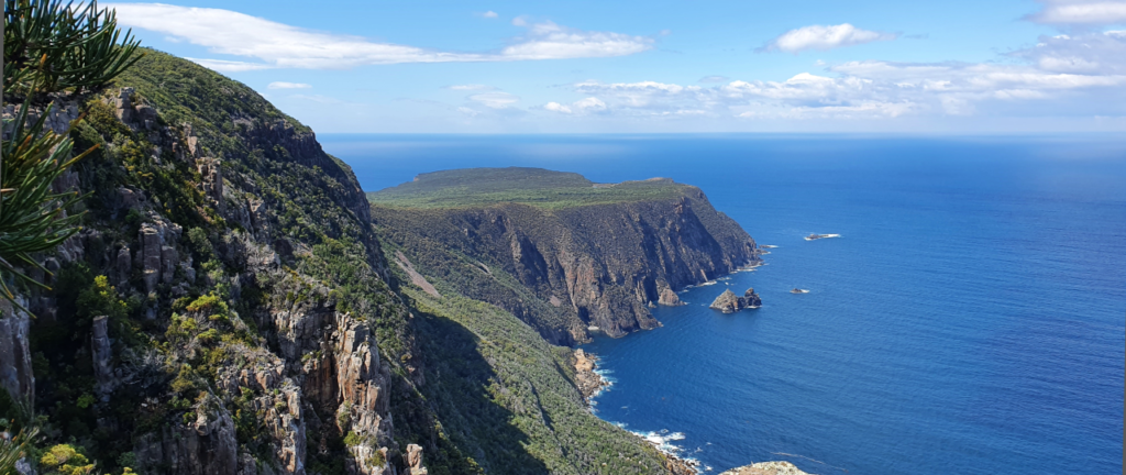
Spring is coming, and to celebrate, we will enjoy the breathtaking walk along the coast out to Cape Raoul. The newly refurbished track climbs through open forest to a cliff edge that may take some walkers by surprise. From there on the 14km return walk, through heath and light forest, it’s never far from those jaw-dropping cliffs. This 5 hr walk is suitable for experienced walkers and older children, and not suitable for prams, strollers or wheelchairs.
Meeting Times and Places:
If you are interested in going on this walk, please phone Dan Hutchison on 0457 765 907. The departure time is 8 am from Citywide Baptist Church Mornington car park. We would expect to be at Cape Raoul car park by about 10 am. If you wish to meet with the group at any other place, please arrange with the leader. Please be at any meeting place 5 minutes ahead of departure time. However, you still need to contact the walk leader, if intending to walk by Thursday 2nd Sept. The leader should be notified of any other people you intend to bring along. Please be at any meeting place 5 minutes ahead of departure time.
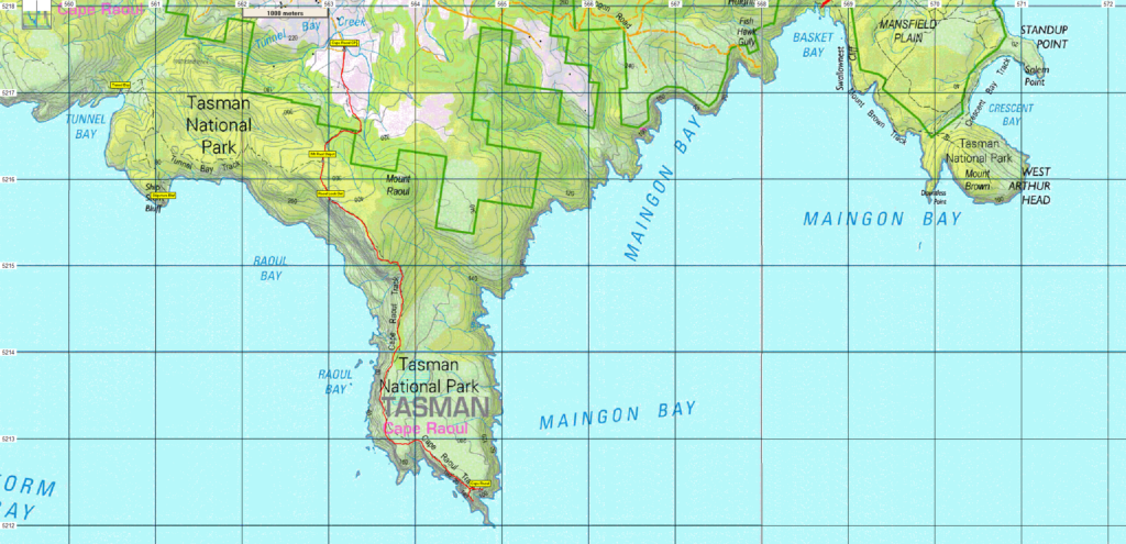
To access this area from Southern Tasmania: From Hobart take the Tasman Hwy to Sorell. Follow the highway into the town of Sorell and turn right at the lights onto the Arthur Hwy A9 and follow for 70km to Port Arthur. Take the B37 from Port Arthur. Drive 8km west of Port Arthur, then turn left at the sign to Highcroft and Stormlea, located at Parsons Bay Creek. Drive along Stormlea Road for 9km (dirt road) to the carpark.
Warnings:
S… Steep incline (actually decline) for at least part of the way
You should carry wet weather gear as well as warm clothing in case of sudden weather changes. Walkers should carry water with them, suggest 1 litre. Also bring your lunch and snacks.
Map details: Cape Raoul: 1:100000 map is Tasmap 8411 (Storm Bay) and 1:25000 map is 5521 (Raoul)
Map references:
Short ref. na
Zone Easting Northing Latitude Longitude
55G 55 564751.2 5212405.2 -43 14.3023 47 47.8500
No peakbagger points will be visited during this walk. For listing of peakbagger points, see the Hobart Walking Club Peakbagger’s Guide (2000 revision) which can be downloaded (Excel) from http://tastracks.webs.com/peakbaggers.htm The same web page contains several other listings of Tasmanian peaks.
For GPX (.gpx) and Google Earth (.kml) versions of the track: Click here to browse our collection.
Direct links: GPX for this walk … KML for this walk