Collins Cap and Collins Bonnet Circuit - Sat. 6th November
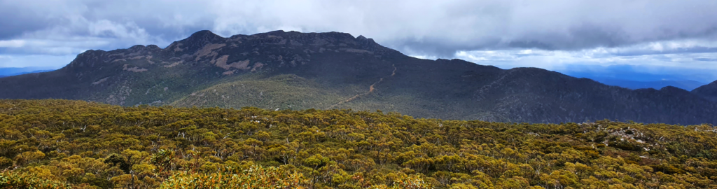
For the adventurers out there, our next Bluegum Pilgrim walk will be to Collins Cap and Collins Bonnet Circular Route on the Mt. Wellington Range. These peaks dominate views of the Wellington Range from both north and south and offer spectacular outlooks. Due to the very steep ascent and some boulder scrambling, this walk is more suited to reasonably fit and energetic walkers, including older and resilient children.
Walk Route:
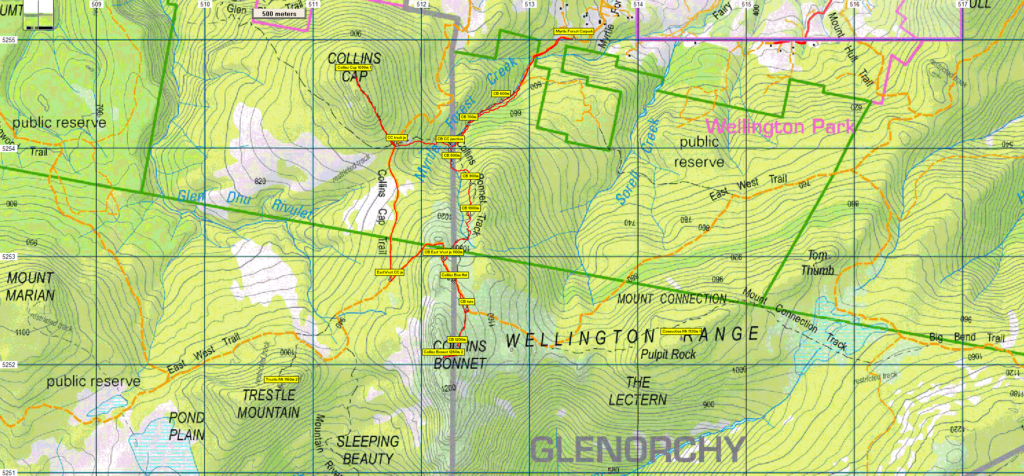
We will be taking the direct and stepped route from Myrtle Forest Creek track from Springdale. From the car park at the end of Myrtle Forest Road (alt. 550m), the track rises steeply southwest, gaining about 200 m over the next km to reach the Collins Cap junction. Swinging more to the south, a further 350 m is gained over the next km to reach the more open alpine area before a respite of a more level few hundred metres, partly by the East West Trail, to reach the final climb to Collins Bonnet. The route rises over the rocky boulders that shoulder Collins Bonnet, (alt. 1260m) 3 km from the carpark.
The same route is followed back to the fire trail, which is followed for 1.2 km, first north past where we joined it earlier, then descending southwest to reach the junction of the Collins Cap fire trail. This is followed north a further 1.2 km to reach the Collins Cap walking track at alt. 900m. This climbs northwest and gains about 200 m over the next 800 m, so it's quite steep! The summit of Collins Cap (alt 1098 m) again offers splendid views on a good day. From there, the same track is followed down, this time crossing the fire trail and descending through the rainforest, re-joining the Myrtle Forest Creek track, and returning to the car park. This 12.2 km walk is estimated to take 5 hours.
Meeting Times and Places:
If you are interested in going on this walk, please phone Dan Hutchison on 0457 765 907. The walk will start at 9:30 am from the car park at the end of Myrtle Forest Rd, and you should meet the group there If you need a lift, please let Dan know when registering. However, you still need to contact the walk leader,. The leader should be notified of any other people you intend to bring along. Please be at any meeting place 5 minutes ahead of departure time.
To access this area from Southern Tasmania: From Hobart, head north on the Brooker Highway and exit at Berriedale. Follow Berriedale Road for 8km towards Collinsvale (Berriedale Road will turn into Collinsvale Road). Once in Collinsvale, continue past the general store and take a sharp left onto Springdale Road. Continue for 1.8km before turning left onto Myrtle Forest Road. The Collins Cap trail begins here. Parking is available adjacent to the boom gate. Picnic and toilet facilities are available 500m further up. (drive route details courtesy of TasTrails)
Warnings:
B Boulder field – walkers need to be able to confidently step from rock to rock
S Steep incline for at least part of the way
E Exposed alpine conditions ; can be dangerous in poor weather if not adequately equipped
Walkers need wear good sturdy boots (waterproof would be a nice bonus). Gaiters can add to comfort. You should always carry wet weather gear as well as warm clothing in case of sudden weather changes. This walk will be largely above 1000m altitude so please be prepared for cold and wet weather regardless of the forecast.
Click this link for a more detailed discussion of Preparation, Food and Safety guidelines for Boots N’ All walks, and especially preparation for exposed alpine conditions.
Bring your lunch and snacks!
Map details:
Collins Bonnet - Collins Cap area: 1:100000 map is Tasmap 8312 (Derwent) and 1:25000 map is 5025 (Collinsvale)
Collins Bonnet: Map reference: 121518
Zone Easting Northing Latitude Longitude
55G 5 12 200 52 52 050 -42.88405 147.14940
Collins Cap: Map reference: 113545
Zone Easting Northing Latitude Longitude
55G 5 11 380 52 54 680 -42.86038 147.13930
Collins Bonnet and Collins Cap are worth 2 and 1 peakbagger points respectively. For listing of peakbagger points, see the Hobart Walking Club Peakbagger’s Guide (2000 revision) which can be found and downloaded (as an Excel spreadsheet) from http://tastracks.webs.com/peakbaggers.htm The same web page contains several other listings of Tasmanian peaks.
For GPX (.gpx) and Google Earth (.kml) versions of the track: Click here to browse our collection.
Direct links: GPX for this walk … KML for this walk