Due to postponement of the Cradle Mountain walk, this will be our first Boots N' All walk for the year - provided we don't get closed out by Covid!
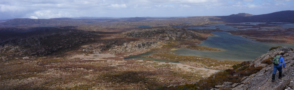
The entire walk is in the high alpine expanse of the Central Plateau, taking us through areas that were badly affected by the bushfires of 2016, but hopefully showing signs of recovery, as well as unaffected parts with clusters of pencil pines and hopefully, a great showing of alpine wildflowers. Blue Peaks itself offers a vast panorama of lakes and peaks to the east, south and west, and despite being not much more than 4 km from the car, gives you a feeling of wilderness remoteness. Depending on the energy of the party (and your leader), we may explore a little to the southeast before doubling back to Blue Peaks. Otherwise, after leaving the summit, we will drop off to the northwest to explore the open grassy valley around Frozen Lagoon. Energetic and resilient children should be able to manage this walk..
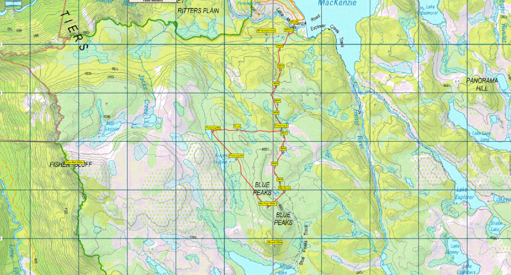
Walk route:
From the car park at Lake Mackenzie, already 1100m altitude, we walk around the boom gate, along the road across a bridge and soon leave the road to follow the Blue Peaks track for about 2.5 km, climbing about 150 m. If we decide to do the southeast ramble, we leave the track at this point and continue off track through low alpine vegetation, generally easy enough to walk through. There are various points at which we could turn west to re-join the Blue Peaks track, but if the party is travelling well, we could end up as far south as Grassy Lake before turning northwest to head for Blue Peaks. This ramble could be up to 7 km, but will likely be less. Arriving at Blue Peaks, we branch off to ascend the highest point. alt. 1350m. If we didn't take the southeast diversion, we will drop off to the northwest, and head 2 km alongside Frozen Lake, before heading 1.5 km east to re-join the Blue Peaks track, which we follow north for about 2.5 km to return to the cars.
Meeting Times and Places:
If you are interested in going on this walk, please phone Basil Tkaczuk on 03 6331 1155 to book in. The departure time is 7:30 am from Door of Hope carpark in South Launceston. Meeting points along the way could be 8:00 at the Mole Creek Road roundabout at the western end of Deloraine, 8:20 at Mole Creek or 8.35 at the Lake Mackenzie (Devil's Gullet) Road junction with the Mersey Forest Road. However, you still need to contact the walk leader per details above if intending to walk. The leader should be notified of any other people you intend to bring along. Please be at any meeting place 5 minutes ahead of departure time.
To access this area from northern Tasmania:
From Launceston, proceed along the Bass Highway to Deloraine (about 51 km), but do not turn off at the eastern exit into Deloraine. Instead, continue across Meander R. and up hill to the western exit, and to the roundabout at start of Mole Creek Rd. A further 24km will bring you to Mole Creek. Continue west past Mole Creek, on what is now Liena Rd, making sure you turn south at the caravan park 4 km from the town. The road continues west until about 14 km from Mole Creek, it branches south, now called Mersey Forest Road. A little over 6 km south, you will pass a turnoff to Cradle Mountain and Sheffield, and about 300 metres further, take the turn on left to Devil's Gullet/Lake Mackenzie. Follow this road about 19 km, and just short of the Lake Mackenzie dam, turn south to find the car park and boom gate from where the walk starts.
Warnings:
The following codes [from our 2022 walks calendar] apply:
D Drive distance requires early departure – usually 7:30 am
M (depending on off-track sections) Marshy or muddy sections be prepared to walk with wet feet.
E...Exposed alpine conditions – can be dangerous in poor weather if not fully equipped.
This walk is above 1100 metres altitude for the whole distance and can be very exposed if the weather is bad, even at this time of year. Be prepared! Walkers should wear sturdy boots due to uneven surfaces. Gaiters recommended due to off-track walking. You should always carry wet weather gear as well as warm clothing in case of sudden weather changes. For equipment guidelines, CLICK HERE.
Map details:
Blue Peaks (alt. 1350 m): 1:100000 map is Tasmap 8114 (Mersey) and 1:25000 map is 4438 (Lake Mackenzie)
Map reference:
Short ref. 479815
Zone Easting Northing Latitude Longitude
55G 4 47 890 53 81 640 -41.71533 146.37357
For the peakbaggers, Blue Peaks is worth 1 point. For listing of peakbagger points, see the Hobart Walking Club Peakbagger's Guide (2000 revision) which can be downloaded (Excel) from http://tastracks.webs.com/peakbaggers.htm The same web page contains several other listings of Tasmanian peaks.
For GPX (.gpx) and Google Earth (.kml) versions of the track: Click here to download.
Direct links: GPX for this walk … KML for this walk
Right-click on the file and save target as to a location of your choice. (Suggest you click the Last modified at top to sort by date to get the most recent at top to find the file for the next walk).