This walk was to happen on 8th January, but your leader was unimpressed by the potential for rain, and would rather a clear day to reach the summit!
We're not sure of the last time Boots N' All had a walk aiming to reach the summit of the world-famous Cradle Mountain. A number of walks in recent years have visited the area in April or early May to appreciate the colours of the fagus, but this spring walk will hopefully allow you to appreciate the vast panoramas of the spectacular alpine wilderness.
There are some complications these days to do with boom gates being locked after 8 am, or because an allowed quota of vehicles has already entered the Dove Lake-Ronny Creek-Waldheim area, and this would mean using the shuttle bus on arrival, resulting in up to an hour's delay before the walk can be commenced. Your leader will need to make decisions based on what conditions apply on the day, but hopefully, the peak can be reached.
Extra: Since this walk was last revised, we have been in touch with Parks Tas, and managed to negotiate access through the boom gate at 8 am for a party of up to 3 cars - which means people may need to squash in, 5 to a car, for the last few km of the trip. A party of up to 15 walkers would still be a great turnout, though!! Being there on time will be very important, given the complexities of negotiating guaranteed access via Parks Tas.
Due to the distance, altitude and rough terrain, this walk is rated "hard" and is suited to walkers, including older and resilient children, who have a good level of fitness, and have experience walking on tracks of varying quality - part boardwalk, part steep and rocky path (very uneven and quite demanding in a few places), and able to keep going at a good pace for sustained distances. Because of the exposed alpine conditions, walkers must be fully prepared for poor weather. Please see the warnings and equipment suggestion link below.
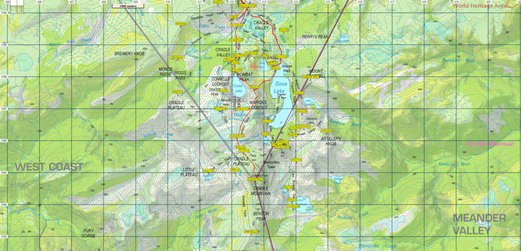
Walk Route:
The route on the day will begin from either Dove Lake or Ronny Creek. If departing from Dove lake (alt. 940m), the track skirts around the western shore of the lake for about 1 km before rising very steeply to the west over the next km to reach Marions Lookout (1180m). The track continues south for the next 2 km over a relatively level and open alpine plateau to Kitchen Hut. Shortly past the hut, the Cradle Mountain track is joined, rising moderately at first, and soon very steeply, with boulder scrambling towards the summit ridge to reach the summit (alt. 1545m), 1.2 km from Kitchen Hut. Total distance is 4.9 km each way.
If it is necessary to begin from Ronny Creek (alt. 870m), the likely route is via Crater Lake to Marion's Lookout. Grades are somewhat gentler, with some steep pinches, but slightly more altitude to gain, and about 1.7 km longer - 6.6 km each way to the summit.
Meeting Times and Places:
If you are interested in going on this walk, please phone your walk leader, Kent Lillico, ph. 0428 451 528 to book in.
New departure and meeting times: The departure time is 6:15am from the Door of Hope Church car park, Launceston, but please be there by 6:10 am. If coming from elsewhere, meet Kent at Moina at 7:30 am (junction of Cethana Rd. C136 and Cradle Mountain Rd. C132), but please let him know about this. The group should arrive at the boom gate by approx. 7:50 am. If you would like to arrange to meet the group at these places or elsewhere, please arrange with the leader, and please be at any meeting place 5 minutes ahead of the listed time. The leader must be notified of any other people you intend to bring along.
To access this area from northern Tasmania: Roads to Cradle Mt. are well signposted, and the area can be accessed from several directions. From Sheffield, go south along Claude Rd (C136) through Gowrie Park and westward down into the Forth Valley (now Cethana Rd but still C136)), continuing up the other side to Moina. Turn south into Cradle Mt. Rd C123 After approx. 20 km, you will reach the Cradle Mt. turnoff. Turn left (still called Cradle Mt. Rd.) and approx. 4 km south, you will arrive at the Pencil Pine area. At that point, it will be necessary to determine if vehicle access to Ronny Creek, Waldheim or Dove Lake is possible. Sometimes the road is closed due to too many vehicles, in which case it will be necessary to catch a shuttle bus. Otherwise, a further 5 km drive will bring us to Ronny Creek carpark.
Warnings:
The following codes [from our 2021 walks calendar] apply:
D Drive distance requires early departure
B Boulder field – walkers need to be able to confidently step from rock to rock
S Steep incline for at least part of the way
E Exposed alpine conditions ; can be dangerous in poor weather if not adequately equipped;
L Long day's walking
Walkers need wear good sturdy boots (waterproof would be a nice bonus). Gaiters can add to comfort. You should always carry wet weather gear as well as warm clothing in case of sudden weather changes. This walk will be mostly above 1000m altitude so please be prepared for cold and wet weather regardless of the forecast.
For equipment and safety guidelines, Click Here, especially regarding preparation for exposed alpine conditions.
Map details:
Waldheim/Dove Lake/Cradle Mt area: 1:100000 map is Sophia and 1:25000 map is Cradle.
Map reference: 126845
Zone Easting Northing Latitude Longitude
55G 4 12 730 53 84 690 -41.68478 145.95140
Cradle Mountain is rated at 4 peakbagger points. For listing of peakbagger points, see the Hobart Walking Club Peakbagger's Guide (2000 revision) which can be found and downloaded (as an Excel spreadsheet) from http://tastracks.webs.com/peakbaggers.htm The same web page contains several other listings of Tasmanian peaks.
For GPX (.gpx) and Google Earth (.kml) versions of the track: Click here to browse our collection.
Direct links: GPX for this walk … KML for this walk
Right-click on the file and save target as to a location of your choice. (Suggest you click the Last modified at top to sort by date to get the most recent at top to find the file for the next walk).