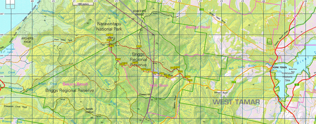
Point Vision is a prominent hill in the Narawntapu National Park. It has been a popular destination for Boots 'n' All over the years, although it has not appeared on the programme for about 10 years now. The more usual approach is from the west at the Bakers Beach end of the national park, returning the same way, or alternatively continuing down the ridge to the coastline and then back along Bakers Beach itself. This time however we will take a different approach with a circuit walk from the east through the Briggs Regional Reserve beginning from Hinds Mill Road.
The walk is 13km in length and should take about 5-6 hours in total including breaks. Most of it will be along vehicular roads, some of which are well used fire trails and others somewhat more overgrown. About 1½ km will be off track. There will be about 300m of climbing on the way to the peak of Point Vision, steep in some places, more gentle in others. The route back will be mostly either fairly flat or gently downhill, with just a couple of steeper sections. Generally the walking will be quite easy, but in the off track section it will be bit rougher and steep and slippery in places. Also in the last road section before getting back to the cars, the road may be overgrown and there may be some fallen logs to clamber over here and there. This section will also include several creek crossings, although these are not difficult. There are also a few muddy sections so good boots and preferably gaiters would be an advantage. This walk is rated medium and energetic able older children should be able to manage it.
Walk route:
The walk starts at about 100 m altitude at the boom gate on Hinds Mill Road. We will follow this road initially, but soon leave it to follow a good fire trail in a westerly direction uphill through the Briggs Regional Reserve. Eventually we will turn right and head in a northerly direction steeply uphill across the National Park boundary and then follow the last part of the official Point Vision Track to the summit at an elevation of 370m, reaching it after about 2½ hours. Despite being named Point Vision, in the past the views from the summit were limited by surrounding trees. However, somewhat surprisingly for a national park, some of these have been felled recently so that if the weather is clear we will now enjoy some nice views especially to the west towards Bakers Beach and Port Sorell. After lunch on top we will head back down retracing our steps for about 30 minutes to the road junction just outside the national park. Here we will head south, straight ahead towards Flowers Hill instead of turning left to follow our upward route. After about 20 minutes of nice forest road walking we will head left off track in an easterly direction down the hill for about 45 minutes to join up with Hinds Mill Road again. From here we will follow the road back to the car. Initially it is overgrown with several creek crossings, but it gradually becomes more open with easier walking, reaching the cars after about one hour.
Meeting Times and Places:
If you are interested in joining this walk, please phone, text or email the leader, Phil Andrew, on 6300 1067, 0408 014 757, or pandrew.tas@gmail.com. The departure time is 9:00 am from Door of Hope carpark in South Launceston. Being a federal election day, this meeting time will allow time for our walkers to vote before they come. We should expect to be back in Launceston by around 5.00 pm. If you would like to arrange to meet elsewhere, please arrange with the leader, and please be at any meeting place 5 minutes ahead of the listed time. The leader must be notified of any other people you intend to bring along.
To access this area from northern Tasmania:
From Launceston, follow the West Tamar Highway (A7) about 50 km to Yorktown, which should be reached after about 45 minutes. Turn left onto Bowens Road (C 741) and follow this for 4½ km until you reach a road junction to the right, which is Hinds Mill Road. There is a boom gate nearby which will stop further vehicular progress so this is the place to park for this walk..
Warnings:
M... Marshy or muddy sections – be prepared to walk with wet feet.
S... Steep incline (actually decline) for at least part of the way
You should carry wet weather gear as well as warm clothing in case of sudden weather changes. Walkers should carry water with them, suggest at least 1 litre. Also bring your lunch and snacks. For equipment and safety guidelines, Click Here.
Map details:
Point Vision: 1:100000 map is Tamar (TasMap 8215) and 1:25000 map for upper area is Port Sorell (TasMap 4644).
Map reference:
Short ref. n/a
Zone Easting Northing Latitude Longitude
55G 4 72 680 54 45 900 -41.13775 146.67448
No peakbagger points will be reached on this walk. For listing of peakbagger points, see the Hobart Walking Club Peakbagger’s Guide (2000 revision) which can be found and downloaded (as an Excel spreadsheet) from http://tastracks.webs.com/peakbaggers.htm The same web page contains several other listings of Tasmanian peaks.
GPX version of the track: Right-click here to download. Google Earth version of the track: Click here to open in Google Earth [if available on your device].
For the full listing of our extensive GPX and KML files, click here. To find one in a hurry, Ctrl-F to bring up a search box, and type in part of the name of the walk. For some walks, there will be more than one version. Right-click on the file and save target as to a location of your choice.