Our northwest people have come up with a walk that is new to Boots N' All, although it's possible that the former northwest SU walking group might have been there many years ago. Montezuma Falls is certainly worth a visit, and the walk is steeped in the mining history of the west coast, following the formation of the former North East Dundas Tramway, opened on 18th June 1898 to carry ore from the Williamsford mines to Zeehan, from where it went on to Burnie for shipping to the smelters. Silver, lead and zinc were the main metals produced from the mines. The railway ceased operating in 1929, officially closing on 5 July 1932, although the Hercules mine, high on Mt. Read, re-opened from 1999 to 2002, using modern machinery and methods to extract further value from the old mine. The linked articles make fascinating reading, including the fate of the retired locomotives.
Walk Route:
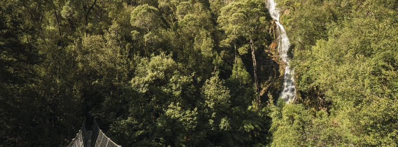
The walk starts at Williamsford, where a scattered handful of buildings, along with concrete structures and other remnants, are all that is left of the once bustling community. The track follows the former tramway through quite open rainforest that includes leatherwood, myrtle, sassafras, giant tree ferns and many kinds of fungi, along with a variety of birdlife. At first, the direction is southwest for about 1.5 km, before swinging northwest for another km or so, then west (but lots of bends to the north and south) for another km or so, finally heading south for the best part of another km to reach the falls. There is plenty of evidence of the former railway - you are able to see the remains of bridges, rails, and sleepers. The track eventually comes right to the base of the 104m high falls, and to a bridge that offers great views back to the falls, and out to the wild western rainforests. Return via the same track. Information source Parks Tasmania. Walk distance is a little over 5 km each way, and should take about 3 hours return, plus breaks. This is Tasmania's western region, renowned for wet weather. Mt. Read features more often than not in rainfall reports, and usually tops the state for precipitation, so wet weather gear is essential, even if the forecast looks promising. Do expect conditions to be very wet underfoot. The walk is rated easy, and is suitable for resilient children.
Meeting Times and Places:
If you are interested in going on this walk, please phone Darren Wunder on 0438 557 046 to book in. Meet 7 am at Hiscutt Park, Crescent Street Penguin by taking the right hand turn straight after the traffic lights if coming from Burnie or off the Bass Highway. A pond and windmill make it easy to spot. The next meeting spot is at Burnie McDonalds at 7:30 am, and then Tullah on the Murchison Highway by about 8:45 am. Just as you enter Tullah from the north, and almost opposite Mackintosh Dam Rd, there is a small park next to the Wee Georgie Wood Railway. From there, it is about 30 minutes further to Williamsford. Please negotiate any alternative travel arrangements with the leader, and please be at any meeting place 5 minutes ahead of the listed time. The leader must be notified of any other people you intend to bring along.
To access this area from northern Tasmania:
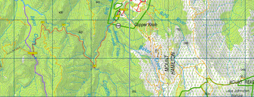
To access Montezuma Falls from Burnie: Head south via Mount St and Ridgley Hwy/B18 to reach Ridgley, then, continue a further 42 km south along Ridgley Hwy to reach the Waratah junction. Continue south along the Murchison Hwy for another 42 km to reach Tullah. A further 14 km brings you to Rosebery, and from there, 1.5 km along Murchison Highway to reach the Williamsford Rd. junction on the left. Follow that road for 6.5 km to reach Williamsford.
To access this area from northern Tasmania: From Launceston, proceed as if heading for Cradle Mt, the most common route being Bass Hwy past Deloraine to Elizabeth Town, then left into Railton Road, following through to Kimberley. Cross the Mersey R. bridge and turn left into Bridal Track Rd, continuing through to Sheffield. From Sheffield, go south along Claude Rd through Gowrie Park and westward down into the Forth Valley (now Cethana Rd.), continuing up the other side to Moina. Turn south into Cradle Mt. Rd. After approx. 20 km, you will reach the Cradle Mt. turnoff. Do not turn left, but continue a further 27 km or so to reach the Murchison Highway. Turn left and head south another 22 km to reach Tullah. See above for rest of route.
Accommodation: If travelling from northern Tasmania, it would be a very long return trip for one day, although trips to Mt Murchison, a similar distance, have been done as Boots N' All day walks in the past. For walks in that area, some northern walkers choose to come through on Friday afternoon and either camp (in winter???) or book into Tullah Lakeside Lodge for the night.
Warnings:
M… Marshy or muddy sections – be prepared to walk with wet feet.
D... Drive distance requires early departure
You should carry wet weather gear as well as warm clothing in case of sudden weather changes. Also bring your lunch and snacks. For equipment and safety guidelines, Click Here.
Map details:
Montezuma Falls: 1:100000 map is Sophia (TasMap 8014) and 1:25000 map for the area is Dundas (TasMap 3636).
Map reference:
Short ref. n/a
Zone Easting Northing Latitude Longitude
55G 3 73 479 53 67 079 -41.50284 145.28570
No peakbagger points will be reached on this walk. For listing of peakbagger points, see the Hobart Walking Club Peakbagger’s Guide (2000 revision) which can be found and downloaded (as an Excel spreadsheet) from http://tastracks.webs.com/peakbaggers.htm The same web page contains several other listings of Tasmanian peaks.
GPX version of the track: Right-click here to download. Google Earth version of the track: Click here to open in Google Earth [if available on your device].
For the full listing of our extensive GPX and KML files, click here. To find one in a hurry, Ctrl-F to bring up a search box, and type in part of the name of the walk. For some walks, there will be more than one version. Right-click on the file and save target as to a location of your choice.