Late news: Phil has Covid - a very mild case at present. He is expecting to be out of quarantine by Saturday but we should be able to come up with another leader if not.
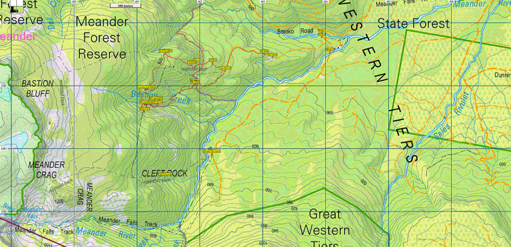
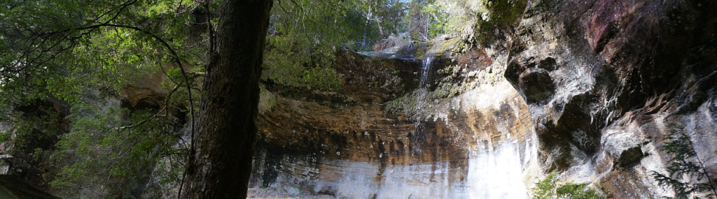
The upper reaches of the Meander Valley have a number of waterfalls hidden in tributaries of the river. Hidden Falls is a surprising and spectacular feature less than 200 metres from the better known Bastion Cascades, which will also be visited. This walk in the upper Meander Valley area starts at an old quarry at 580 metres altitude, and rises west and then south-west, contouring around into the valley of Bastion Creek at about 700m altitude, to reach the cascades after about 2.5 km walk from the start. Doubling back a couple of hundred metres, the track then rises steeply and sidles around to the top of the cascades, from which the creek is crossed and Hidden Falls is reached after a steep rise through the forest.
Returning to Bastion Creek, we then climb again, further north to about 900m. Some amazing rock formations are passed, the largest, Crowdens Croft, offering shelter for a rest break. The track then contours north for a further kilometre, past more interesting formations, to the most interesting of all, the "stone hut" with its associated residents. From there, the track descends eastwards for a further 1.5 km to return to the start. The walk is rated "medium" due to the steep grades and some track sections that require clambering, and is suitable for reasonably fit and suitably equipped walkers familiar with wilderness forest walking. Energetic older (accompanied) children should cope with this walk which is approximately 8 km in total.
Meeting Times and Places:
If you are interested in going on this walk, please call walk leader, Phil Dawson email pidasms@gmail.com or ph. 6382 3561 after 6:30 pm to book in. The departure time is 8:00 am from Door of Hope car park. Alternative meeting place: Deloraine (train park - see below) 8:30 am. If you wish to meet with the group at any other place, please arrange with the leader. Please be at any meeting place 5 minutes ahead of departure time. However, you still need to contact the walk leader, if intending to walk. The leader should be notified of any other people you intend to bring along. Please be at any meeting place 5 minutes ahead of departure time.
To access this area from northern Tasmania: From Launceston, head towards Deloraine on the Bass Highway (50 km) and take the first (eastern) turn from the highway into Deloraine, and when crossing the bridge, turn right at roundabout to enter the “train park” car park, nowadays the usual Boots N' All meeting place.
From Deloraine, head south along the "Lake Highway" - now Highland Lakes Rd. (but the first bit may be called Meander Rd!). Make sure you stay on Meander Rd and go straight ahead (DON'T turn left) at 7 km from Deloraine, where there is a signposted junction for Highland Lakes Rd. Continue a further 9 km to Meander and continue through the town. After about 6 km, the road swings right. About 2.5 km further, the road turns south and crosses the first of the new bridges (Smoko Creek). Just across this bridge, turn off to the right and follow the fairly steep road for about 1 km to reach the old quarry from which the walk starts.
Warnings:
The following codes [from our 2022 walks calendar] apply:
S Steep incline for at least part of the way
M Marshy or muddy sections - be prepared to walk with wet feet.
E Exposed alpine conditions; can be dangerous in poor weather if not adequately equipped.
You should carry wet weather gear as well as warm clothing in case of sudden weather changes. Also bring your lunch and snacks. For equipment and safety guidelines, Click Here.
Meander Falls area: 1:100000 map is Meander (Tasmap 8214) and 1:25000 map is Quamby Bluff (Tasmap 4638)
Map references:
Short ref. n/a
Meander Falls:
Zone Easting Northing
55G 4 61 212 53 81 689
No peakbagger points will be visited on this walk. For listing of peakbagger points, see the Hobart Walking Club Peakbagger's Guide (2000 revision) which can be downloaded (Excel) from http://tastracks.webs.com/peakbaggers.htm The same web page contains several other listings of Tasmanian peaks.
GPX version of the track: Click here to download. Google Earth version of the track: Click here to download.
Right-click on the file and save target as to a location of your choice. (Suggest you click the Last modified at top to sort by date to get the most recent at top to find the file for the next walk).