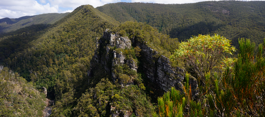
The short and cold winter days will also hopefully be good waterfall weather, with rain and snow topping up our streams. Both these short walks are in the Chudleigh-Mole Creek area, less than an hour from Launceston, and about 12km apart by road. The Alum Cliffs walk is less than 1 km each way, and Westmorland Falls is about 2 km each way, gaining about 80m altitude to reach the falls. See Alum Cliffs Lookout and Alum Cliffs Gorge / Tulampanga at Mole Creek and http://molecreek.info/natures-wonders/westmorland-falls/ for information about each walk. Both walks are suitable for energetic younger children but not accessible for prams, strollers and wheelchairs.
The plan for the day is to do Alum Cliffs first, have lunch at Wet Caves reserve, and then head for Westmorland Falls. Depending on conditions, it should be possible to walk along a short section within Honeycomb Cave at the Wet Cave reserve during the lunch break, but nobody should enter the cave alone, and children must be closely supervised.
This walk is rated "easy" and is suitable for walkers, including energetic children, who can cope with wintry and changeable conditions and a somewhat muddy track to Westmorland Falls. Being winter, walkers must be fully prepared for poor weather and should carry layers of warm clothing and a waterproof jacket, as well as a beanie or warm head cover. Please see the warnings below. A change of footwear and perhaps even dry clothing on return to car is suggested. If you have them, gaiters might be helpful for the muddy bits!
Meeting Times and Places:
If you are interested in going on this walk, please phone your walk leaders, Grace Hillman, ph. 0490 840 866 to book in. The departure time is 9:15 am from the Door of Hope Church car park, Launceston. Suggested meeting place if coming from elsewhere could be Mole Creek Rd. roundabout at western end of main street of Deloraine at 9:50 am, or at the small park and public toilets in Chudleigh at 10:10 am. Please discuss alternative meeting times and places with the leader. However, you still need to contact the walk leader per details above if intending to walk. The leader should be notified of any other people you intend to bring along. Please be at any meeting place 5 minutes ahead of departure time.
To access this area from northern Tasmania:
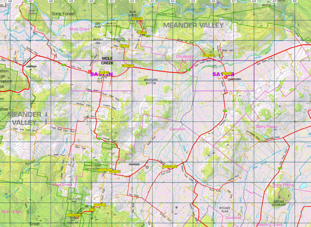
From Launceston, proceed along the Bass Highway to Deloraine (about 51 km), but do not turn off at the eastern exit into Deloraine. Instead, continue across Meander R. and uphill to the western exit, and to the roundabout at start of Mole Creek Rd. Continue 16 km to reach Chudleigh. The main road turns sharply north. Continue a further 1.4 km and turn right into Mersey Hill Rd. Follow that road for a little over 3.5 km to reach the Alum Cliffs carpark.
After leaving Alum Cliffs, follow Mersey Hill Rd. south then west for 1.4 km (not the way you came) into Miles Rd, then south a further 1 km to re-join Mole Creek Rd. Turn right and follow about 1.4 km into Mole Creek, then turn left into Caveside Rd. Follow south, somewhat east, then south again to reach the junction of Wet Caves Rd. Turn right into that road and head west for 1/2 km to reach the Wet Caves reserve, which is the lunch spot. After lunch, continue south along Wet Caves Road for 1.8 km to reach the Westmorland Falls track.
If coming direct from Chudleigh to Westmorland Falls, instead of turning right in main street to head to Mole Creek, go a further 200 metres west, turn left into Gardner St. and turn right after about 800m into Caveside Rd. Keep on this road for about 8 km to the junction of Wet Cave Rd. and go straight ahead into that road, through a sharp bend to left (location of the Wet Caves reserve - our lunch spot) and reach the Westmorland Falls track a little over 2 km from Caveside Rd.
Warnings:
The following codes [from our 2022 walks calendar] apply:
M Marshy or muddy sections – be prepared to walk with wet feet.
Walkers are advised to wear strong shoes or boots. You should carry wet weather gear as well as warm clothing in case of sudden weather changes. Also bring your lunch and snacks. For equipment and safety guidelines, Click Here.
Map details:
Chudleigh area: 1:100000 map for both destinations is Mersey (TasMap 8114) and 1:25000 map (Alum Cliffs) is Gog (TasMap 4440) and for Westmorland Falls, use Mole Creek (TasMap 4439).
Map references:
Short ref. n/a
Zone Easting Northing Latitude Longitude
n/a
There are no peakbagger points for the area covered by this walk. For listing of peakbagger points, see the Hobart Walking Club Peakbagger's Guide (2000 revision) which can be found and downloaded (as an Excel spreadsheet) from http://tastracks.webs.com/peakbaggers.htm The same web page contains several other listings of Tasmanian peaks.
GPX version of the track: Click here to download. Google Earth version of the track: Click here to download.
Right-click on the file and save target as to a location of your choice. (Suggest you click the Last modified at top to sort by date to get the most recent at top to find the file for the next walk).