Note: walk did not go ahead because of adverse forecast.
With warmer days beginning to outnumber the cold and wet ones, we can hope for sunshine as we explore Parsons Track, both a historic route to the Central Plateau, and a logging route featuring the restored Hills Hut. This walk is in the Caveside area, little more than an hour from Launceston, and features plenty of forest, a possible side trip to a giant tree, the hut, and Lofty Lookout, which promises spectacular views on a fine day. See Great Western Tiers - Parsons Track to Hills Hut. Our walk takes us a little further than the hut, so a somewhat longer round trip. Ian may be able to bring along a guest who can give a historic talk on the area at Hills Hut. If this happens, the walk may be a little shorter.
This walk is rated “family” and is suitable for walkers, including energetic children, who can cope with changeable weather conditions and a mostly steady climb along old logging road and bush track beyond that. There are a couple of quite steep pinches. Track conditions can be muddy and slippery in places, and durable, grippy shoes or walking boots should be worn. Please see the warnings below. A change of footwear and perhaps even dry clothing on return to car is suggested. If you have them, gaiters might be helpful for the muddy bits!
Meeting Times and Places:
If you are interested in going on this walk, please phone your walk leaders, Ian Waterhouse, ph. 0428 242 693 to book in. The departure time is 8 am from the Door of Hope Church car park, Launceston. Suggested meeting place if coming from elsewhere could be Mole Creek Rd. roundabout at western end of main street of Deloraine at 8:40 am, or at the small park and public toilets in Chudleigh at 9 am am. Please discuss alternative meeting times and places with the leader. However, you still need to contact the walk leader per details above if intending to walk. The leader should be notified of any other people you intend to bring along. Please be at any meeting place 5 minutes ahead of departure time.
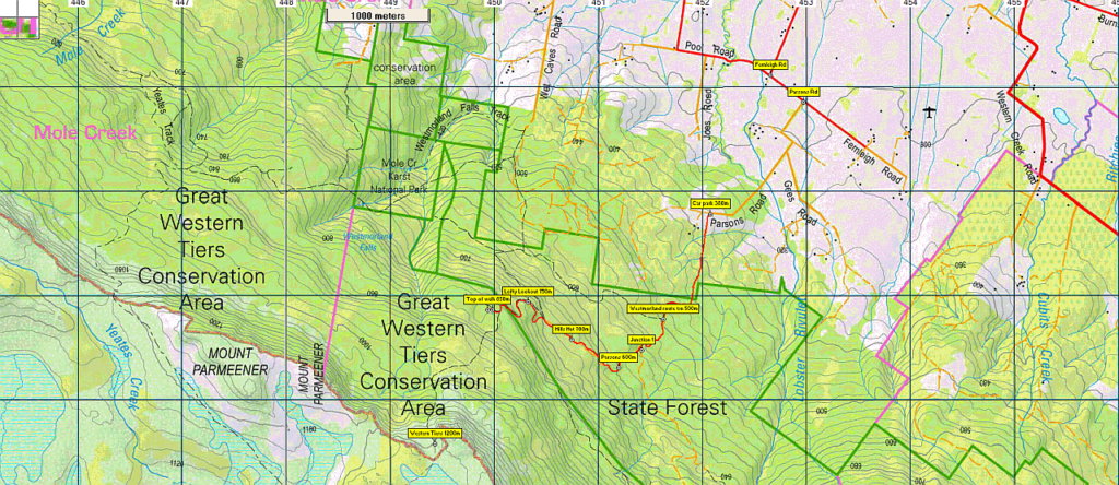
To access this area from northern Tasmania:
From Launceston, proceed along the Bass Highway to Deloraine (about 51 km), but do not turn off at the eastern exit into Deloraine. Instead, continue across Meander R. and uphill to the western exit, and to the roundabout at start of Mole Creek Rd. Continue 16 km to reach Chudleigh. Instead of turning right in main street to head to Mole Creek, go a further 200 metres west, turn left into Gardner St. and turn right after about 800m into Caveside Rd. About 6 km from Chudleigh, you will reach an intersection where Chudleigh Rd branches right, but don't do that. Instead, go straight ahead into Pool Rd and continue south for a further 2 km to reach Fernleigh Rd. Turn left and continue 400m to reach Parsons Rd. Stay on Parsons Rd for just under 2 km to reach the start of the track.
Warnings:
The following codes [from our 2022 walks calendar] apply:
M Marshy or muddy sections – be prepared to walk with wet feet.
S Steep incline for at least part of the way
Walkers are advised to wear strong shoes or boots. You should carry wet weather gear as well as warm clothing in case of sudden weather changes. Also bring your lunch and snacks. For equipment and safety guidelines, Click Here.
Map details:
Parsons Track: 1:100000 map is Mersey (TasMap 8114) and 1:25000 map is Mole Creek (TasMap 4439).
Map references:
Short ref. n/a
Zone Easting Northing Latitude Longitude
n/a
There are no peakbagger points for the area covered by this walk. For listing of peakbagger points, see the Hobart Walking Club Peakbagger’s Guide (2000 revision) which can be found and downloaded (as an Excel spreadsheet) from http://tastracks.webs.com/peakbaggers.htm The same web page contains several other listings of Tasmanian peaks.
GPX version of the track: Click here to download. Google Earth version of the track: Click here to download.
Right-click on the file and save target as to a location of your choice. (Suggest you click the Last modified at top to sort by date to get the most recent at top to find the file for the next walk).