With 2 walks cancelled in September and October due to severe weather, we've decided to put one together at short notice, based on the extended weather forecast for the area **at time of writing.**
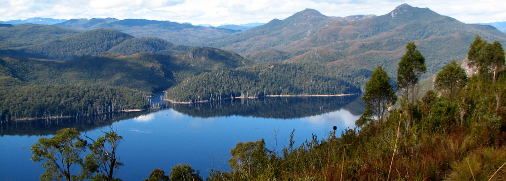
Dominating the township of Tullah and riddled with old mines, Mt. Farrell is a relatively short walk requiring a fairly long drive, but well worth the effort for the views east towards the World Heritage area (views subject to weather conditions... ) and the lovely Lake Herbert, just under the summit ridge.
Walk route:
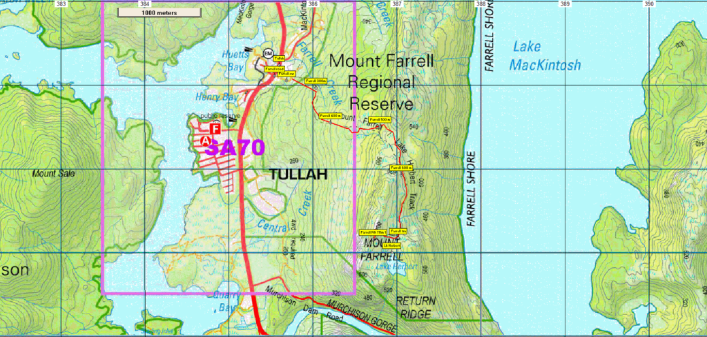
The walk begins at the Murchison Highway in the northern part of Tullah township - altitude 200 metres (a couple of hundred metres south of the remains of a defunct mining and tourist railway and opposite Wombat Lodge), and skirts east and north around the site of a former ore processing mill. A short, quite steep pinch rises through forest, then continues to rise at a slightly more gentle pace through heathlands, skirting south and then east to meet the main ridge of the mountain. This is followed south to a reasonably level section which follows the 600 metre contour for about 1 km south, eventually reaching Lake Herbert. Before this, we will branch west and climb steeply for about 400 metres, to reach the summit - altitude 711 metres. Even at this altitude, there are remains of mining explorations. We will then descend SE to reach Lake Herbert - a great place for a rest and some photography, before retracing the track north and back down to Tullah. Walk distance is about 4 km each way, and the walk should be fine for energetic children.
While not particularly high, the summit area is subject to exposed alpine conditions, so walkers must be fully prepared for poor weather. Please see the warnings below.
Meeting Times and Places:
If you are interested in going on this walk, please phone or email Basil Tkaczuk on 6331 1155 (mob. 0438 664 402) to book in. The departure time is 7:00 am from the Door of Hope Church car park, Launceston. Suggested meeting places if coming from elsewhere could be Sheffield at Claude Rd. turnoff at 7:50 am or Moina at 8:20 am. If you would like to arrange to meet the group at these places or elsewhere, please arrange with the leader, and please be at any meeting place 5 minutes ahead of the listed time. The leader must be notified of any other people you intend to bring along.
To access this area from northern Tasmania: The area can be accessed from several directions, but from Launceston, proceed as if heading for Cradle Mt, the most common route being Bass Hwy past Deloraine to Elizabeth Town, then left into Railton Road, following through to Kimberley. At time of writing, Bridal Track Rd is still listed as closed due to flood damage, so continue to Railton, turning left into Sheffield Rd (B14), continuing through to Sheffield. From Sheffield, go south along Claude Rd through Gowrie Park and westward down into the Forth Valley (now Cethana Rd.), continuing up the other side to Moina. Turn south into Cradle Mt. Rd. After approx. 20 km, you will reach the Cradle Mt. turnoff. Do not turn left, but continue a further 27 km or so to reach the Murchison Highway. Continue south about 20 km to reach Tullah. Allow about 2 hours 20 minutes driving from Launceston.
Warnings:
The following codes [from our 2022 walks calendar] apply:
D Drive distance requires early departure
M Marshy or muddy sections – be prepared to walk with wet feet.
S Steep incline for at least part of the way
E Exposed alpine conditions ; can be dangerous in poor weather if not adequately equipped;
Walkers should wear sturdy boots due to uneven surfaces. Gaiters recommended due to off-track walking near the summit. You should always carry wet weather gear as well as warm clothing in case of sudden weather changes. For equipment guidelines, CLICK HERE.
Map details:
Mt. Farrell: 1:100000 map is Sophia (8024) and 1:25000 map is Tullah (3837).
Map reference: 866770
Zone Easting Northing Latitude Longitude
55G 3 83 200 53 56 650 -41.93347 145.59115
55G 3 86 720 53 77 160 -41.74931 145.63752
Mt. Farrell is worth 1 peakbagger point. For listing of peakbagger points, see the Hobart Walking Club Peakbagger's Guide (2000 revision) which can be found and downloaded (as an Excel spreadsheet) from http://tastracks.webs.com/peakbaggers.htm The same web page contains several other listings of Tasmanian peaks.
GPX version of the track: Click here to download. Google Earth version of the track: Click here to download.
Right-click on the file and save target as to a location of your choice. (Suggest you click the Last modified at top to sort by date to get the most recent at top to find the file for the next walk).
When you have downloaded the track file, double-clicking on the Google Earth (kml) track should open Google Earth and zoom in to the location if you have Google Earth installed on your computer. The .gpx version of the track should import into mapping software or devices that support gpx tracks and waypoints.