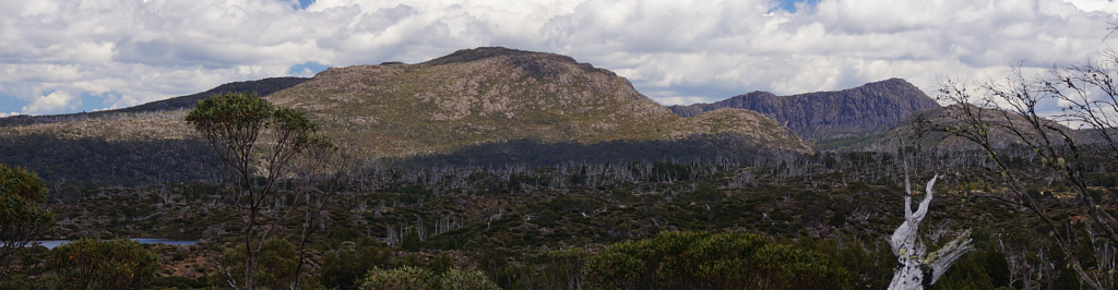
In high summer, the alpine wilderness abounds in beautiful wildflowers, and while the weather can still turn cold and snow, even in January, there can be delightfully warm and sunny days which highlight the spectacular beauty of the world-renowned Walls of Jerusalem National Park. This is a very long day walk - about 24 km return, requiring a consistent pace to be kept up in both directions.
Walk route:
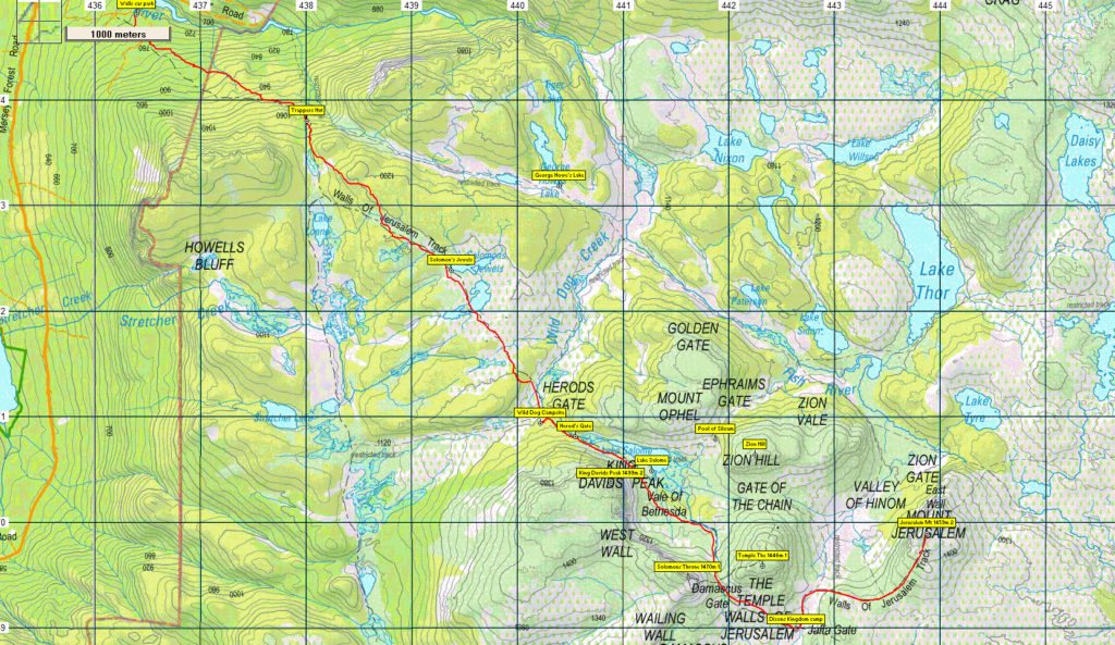
The walk begins with a fairly demanding ascent from the car park (alt. 700 metres) to the plateau (about 500 metres altitude over about 3 km distance), and includes further shorter but steep hauls at Herod's Gate and Damascus Gate (alt. 1380 metres) before descending slightly to the Dixon's Kingdom campsite (alt. 1270 metres) and a final fairly steep pinch to reach the summit of Mt. Jerusalem (1459m). There are a couple of long, fairly level, stretches in between, but the total walk distance to the summit is about 12 km, so a very good level of stamina is needed. Your walk leader will need to be confident in your experience before allowing you to join this walk.
This walk is rated "medium-hard" and is suitable for walkers who have had some experience with steep and rocky tracks as well as off-track alpine walking, and able to keep going for sustained distances. Because of the exposed alpine conditions, walkers must be fully prepared for poor weather, even in summer, and no matter what the forecast is. Please see the warnings below.
Meeting Times and Places:
If interested in going on this walk, please phone or text your walk leader, Kent Lillico on 0428 451 528 to book in. The departure time is an early 6:30 am from Launceston, with Kent meeting the party at the Mole Creek toilet block at 7:30 am.
If you would like to arrange to meet the group at these places or elsewhere, please arrange with the leader, and please be at any meeting place 5 minutes ahead of the listed time.
The leader should always be notified of any other people you intend to bring along, especially for a demanding walk like this one, and you should always contact the walk leader if intending to participate in a particular Boots N' All walk.
To access this area from northern Tasmania: proceed along the Bass Highway to Deloraine (about 51 km), but do not turn off at the eastern exit into Deloraine. Instead, continue across Meander R. and up hill to the western exit, and to the roundabout at start of Mole Creek Rd. A further 24km will bring you to Mole Creek (sometimes used as a meeting place for our walks - check with leader). Continue west past Mole Creek, on what is now Liena Rd, making sure you turn south at the caravan park 4 km from the town. The road continues west until about 14 km from Mole Creek, it branches south, now called Mersey Forest Road. A little over 6 km south, you will pass turnoffs to Cradle Mountain and Devil's Gullet (Lake Mackenzie) but keep going south, crossing the Mersey at Lake Parangana and passing the turnoffs for Bare Hill and Arm River. Another 17 km should see you cross below the Rowallan Dam. Continue south along the east side of Lake Rowallan, for a little over 5 km, and about 100 metres past the Fish River bridge, you will see the Walls of Jerusalem on the left. Follow this road for 1 km to reach the car park and the beginning of the Walls of Jerusalem walking track.
Warnings:
The following codes [from our 2023 walks calendar] apply:
D Drive distance requires early departure
S Steep incline for at least part of the way
L A long days walk in excess of 3 hours each way
M Marshy or muddy sections be prepared to walk with wet feet.
E Exposed alpine conditions ; can be dangerous in poor weather if not adequately equipped.
Click this link for a more detailed discussion of Preparation, Food and Safety guidelines for Boots N' All walks, and especially preparation for exposed alpine conditions.
Map details & References:
Walls of Jerusalem area: 1:100000 map is Mersey (Tasmap 8114) and 1:25000 maps are Rowallan (Tasmap 4237) and Ada (Tasmap 4436)
Mt. Jerusalem: (Short ref. 437697)
Zone Easting Northing Latitude Longitude
55G 4 43 870 53 69 905 -41.82075 146.32414
Mt. Jerusalem is worth 2 peakbagger points. For listing of peakbagger points, see the Hobart Walking Club Peakbagger's Guide (2000 revision) which can be downloaded (Excel) from http://tastracks.webs.com/peakbaggers.htm The same web page contains several other listings of Tasmanian peaks.
GPX version of the track: Right-click here to download. Google Earth version of the track: Click here to open in Google Earth [if available on your device].
Click here to browse our entire collection of walk tracks, including to find GPX (.gpx) and Google Earth (.kml) versions of the track for this walk.
Click here to learn about using your phone as a navigation device, or to find out about handheld GPS devices.