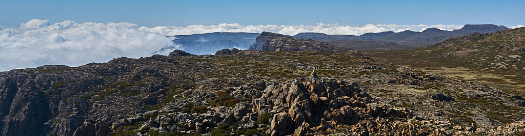
It is some years since Boots N' All last did a walk from the Ben Lomond ski village area. On this walk we will attempt to visit a few of the prominent high points on the Ben Lomond plateau in the vicinity of the ski village. We will follow tracks for part of the time and walk off track for the rest, with nice views from each of the summits if the weather is clear, in which case the walk offers spectacular views to the north and north-east of the state, as well as mountain panoramas of the vast Ben Lomond plateau.
Walk route:
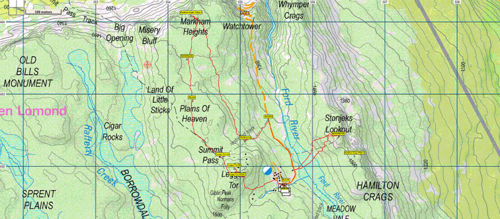
After parking somewhere along the Ben Lomond Road about 500m before the ski village, we will walk back to the Summit Pass Track and follow it southwest for just a few hundred metres. We will then turn right to head north off track for about 2 km to reach Markham Heights summit. This will take about 1½ to 2 hours in total, climbing at least 150m in the process. After savouring the view, we will head due south for about 2 km (a little more to the west than our upward route) to pick up the Summit Pass Track after about 1 to 1½ hours, although we will probably stop for lunch somewhere along the line, perhaps even on the Plains of Heaven! Continuing along this track for about 30 min, we will reach the summit of Legges Tor at 1572m, making it the 2nd highest peak in Tasmania, just 45 metres lower than Mt Ossa. We will then find the easiest route down to the village underneath the ski lift lines and walk along the road to the vicinity of the sewage treatment plants. While we will not linger and savour the moment there, they will provide a landmark for beginning the climb up to Hamilton Crags (confusingly called Stonjeks Lookout on some maps, though that may be incorrect). This is about 2 km return and should take about one hour and involve about 100m climbing. There will be some boulder scrambling required over the last hundred metres or so to get to the summit.
In total the walk will be about 10 km with at least 400m climbing and will take us about 5-6 hours depending on the group and how many rests we need to have on the way. This walk is rated medium because of the off track sections which can be uneven in places and so requires a reasonable degree of fitness and some bushwalking experience. However energetic children should be able to cope well with this walk. There may be drinking water available in places, but you should carry at least one litre of water.
Meeting Times and Places:
If you are interested in going on this walk, please phone Phil Andrew on 0408 014 757 to book in. The departure time is 8:00 am from Door of Hope carpark in South Launceston. An alternative meeting point could be the turnoff to Ben Lomond National Park at 8.30 am. However, you still need to contact the walk leader per details above if intending to walk. The leader should be notified of any other people you intend to bring along. Please be at any meeting place 5 minutes ahead of departure time. Please note that if you are bringing your vehicle, it will need to have a current valid Tasmanian Parks Pass, and you will need to be ready to negotiate the drive up and down Jacob’s ladder, which some drivers (and perhaps some passengers) may find unsettling.
To access this area from northern Tasmania:
From Launceston, proceed via St. Leonards (St. Leonards Rd and Blessington Rd) to the Ben Lomond Road, just short of Upper Blessington – about 48 km. Turn right into Ben Lomond Rd. A little over 10 km up this steep gravel road, keep left to stay on Ben Lomond Rd (do not take the right turn to Carr Villa) and continue to follow the road as it levels out for a little over 2.5 km to reach perhaps the most spectacular section of road in the state - Jacobs Ladder, which zigzags and rises steeply over the next km or so and gaining over 200 m altitude, before levelling off and heading south a little over 2 km to reach the ski village carpark, just over 6 km from the Carr Villa junction.
Warnings:
S Steep incline for at least part of the way
E Exposed alpine conditions – can be dangerous in poor weather if not fully equipped.
B Boulder field – walkers need to be able to confidently step from rock to rock.
This walk is above 1400 metres altitude for the whole distance and can be very exposed if the weather is bad, even at this time of year. Be prepared! Walkers should wear sturdy boots due to uneven surfaces. Gaiters recommended due to off-track walking. You should always carry wet weather gear as well as warm clothing in case of sudden weather changes. For equipment guidelines, Click here.
Map details: Ben Lomond Plateau (northern area): 1:100000 map is Tasmap 8414 (St. Pauls) and 1:25000 map is 5440 (Giblin)
Map reference for Markham Heights:
Short ref. 542039
Zone Easting Northing Latitude Longitude
55G 5 54 320 54 04 080 -41.51307 147.65096
Map reference for Legges Tor:
Short ref. 548018
Zone Easting Northing Latitude Longitude
55G 5 54 960 54 01 840 -41.53320 147.65883
Map reference for Hamilton Crags:
Short ref. 563023
Zone Easting Northing Latitude Longitude
55G 5 56 580 54 02 140 -41.53039 147.67822
Each of the three high points to be visited on this walk is worth 1 peakbagger point. For listing of peakbagger points, see the Hobart Walking Club Peakbagger’s Guide (2000 revision) which can be downloaded (Excel) from http://tastracks.webs.com/peakbaggers.htm The same web page contains several other listings of Tasmanian peaks.
Downloadable tracks for your navigation devices, including mobile phones: GPX track for this walk … KML track for this walk
Click here to browse our entire collection of walk tracks, including to find GPX (.gpx) and Google Earth (.kml) versions of the track for this walk.
Click here to learn about using your phone as a navigation device, or to find out about handheld GPS devices.