Another "short notice" change of plans for Boots N' All. The Mt. Tyndall walk has been cancelled, and a walk that would likely have taken place on 11th March (long weekend) has been brought forward.
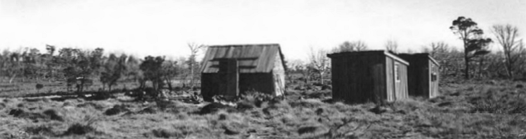
This is an exploratory walk... in other words, your leader hasn't been there before, and is inviting you to join him in following a faint former vehicular track (just visible on Google Earth if you zoom in far enough) to some old huts which may or may not still exist at a point of Great Pine Tier known as Bull Hill, next to a likely former stock route from the south called Doughboy Opening.
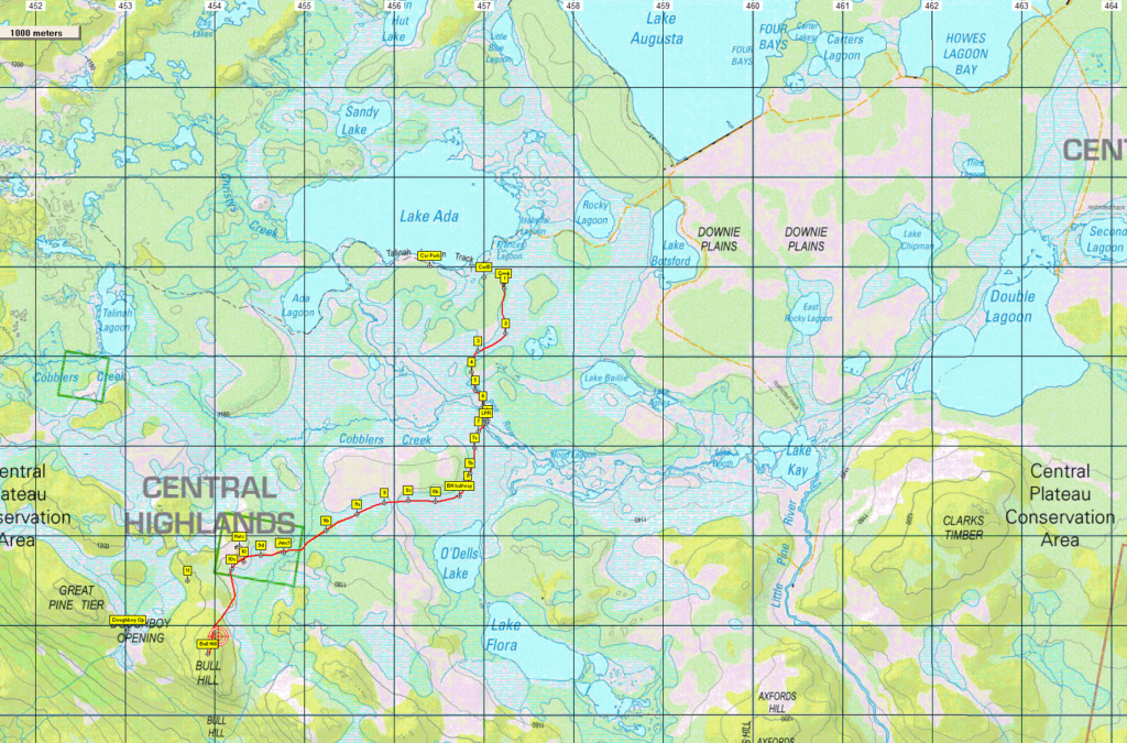
Walk route:
The walk begins near the eastern end of Lake Ada, itself west of Lake Augusta. The old track wanders mostly south for about 3 km, crossing Little Pine River on the way. It then swings SW and continues about 3 km to a slight rise where the huts are/were situated on the right. Bull Hill itself is a further km south, rising 40 or so metres to reach the summit. If time permits, we will drop off the west side of the rise into the upper part of Doughboy Opening. Depending on the vegetation, we may take a more direct line back to the cars. Total distance is about 13 km. Apart from the rise onto Bull Hill, the entire route is more or less flat.
If the day is too hot, we could turn back from the huts, or divert to O'Dells Lake, a little over 3 km from the car. The distances and off-track section make this a medium walk, but it should be suitable for energetic children and less experienced walkers.
Meeting Times and Places:
If you are interested in going on this walk, please phone Basil Tkaczuk on 6331 1155 (or reply to the email) to book in. The departure time is 8:30 am from Door of Hope carpark in South Launceston. The alternative meeting place/time is at the "train park" in Deloraine at 9:05 am. (If coming from east, cross the bridge and turn right at the roundabout). If you would like to arrange to meet the group at these places or elsewhere, please arrange with the leader, and please be at any meeting place 5 minutes ahead of the listed time. The leader must be notified of any other people you intend to bring along.
To access this area from northern Tasmania: From Launceston, head towards Deloraine on the Bass Highway (50 km) and take the first (eastern) turn from the highway into Deloraine. Continue into the town and turn left immediately before the bridge (unless going to the meeting place across the main bridge and turn right to find toilets and old locomotive - see above). From Deloraine, head south along the "Lake Highway" - now officially Highland Lakes Rd. (but the first bit may be called Meander Rd!). Make sure to turn left after 7 km at signposted junction for Highland Lakes Rd. Continue south through Golden Valley, up past Quamby Bluff and Projection Bluff and past Pine Lake. Continue south through Breona, Brandum and other groups of shacks along shores of Great Lake until Liawenee is reached (approx. 58 km from Deloraine). Turn right into Lake Augusta Rd. The dam is reached after approx. 11 km. Turn left and follow the road along the top of the dam, continuing west and SW past another low dam, past the Lake Kay turnoff, past Rocky Lagoon to reach a point 9.5 km from the northern end of Lake Augusta Rd, just south of Frances Lagoon where there is a hut. We will park as near to that point as practicable, but if not permitted, continue to the Talinah track carpark at the end of the road, heading cross-country from there instead of following the first part of the old track.
Warnings:
E... Exposed alpine conditions – can be dangerous in poor weather if not fully equipped
Make sure you have a good supply of drinking water - suggest 1 litre per person. There may be drinkable water on the way. Walkers are advised to wear strong shoes or boots. Gaiters recommended due to off-track walking. You should always carry wet weather gear as well as warm clothing in case of sudden weather changes.
Click this link for a more detailed discussion of Preparation, Food and Safety guidelines for Boots N' All walks.
Map details: Bull Hill: 1:100000 map is Tasmap 8214 (Meander) and 1:25000 map is 4435 (Olive)
Map references:
Short ref. n/a
Zone Easting Northing Latitude Longitude
55G 4 53 917 53 58 679 -41.55349 146.26654
No peakbagger points will be reached on this walk. For listing of peakbagger points, see the Hobart Walking Club Peakbagger's Guide (2000 revision) which can be downloaded (Excel) from http://tastracks.webs.com/peakbaggers.htm The same web page contains several other listings of Tasmanian peaks.
GPX version of the track: Right-click here to download. Google Earth version of the track: Click here to open in Google Earth [if available on your device].
Click here to browse our entire collection of walk tracks, including to find GPX (.gpx) and Google Earth (.kml) versions of the track for this walk.
Click here to learn about using your phone as a navigation device, or to find out about handheld GPS devices.