[This walk was originally to happen on 4th Feb. but the weather forecast was still poor 2 days ahead of the date, so Kent has re-scheduled it for 25th Feb.]
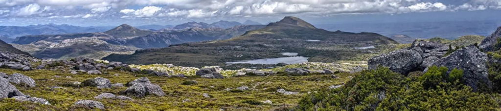
Less well known to people in northern Tasmania, the Tyndall Range, north of Queenstown, is one of the well-kept secrets of the Tasmanian wilderness. Relatively easy to access (even as a rather long day trip from Launceston), the top of the range can be reached after not much more than an hour of climbing, after which, the open alpine areas, combined with rugged backgrounds, are a delight to behold, and in many ways, equal the beauty of the Cradle Mountain area.
Your leader lives on the northwest coast, so quite do-able as a day trip from that region. A bit more of a stretch from the Launceston area, and you may choose to do this as a day trip with an early start, but another option is to camp overnight at Tullah, (or book into accommodation if you prefer a bit of luxury and your budget permits!) - either the Friday or Saturday night. Please arrange this independently.
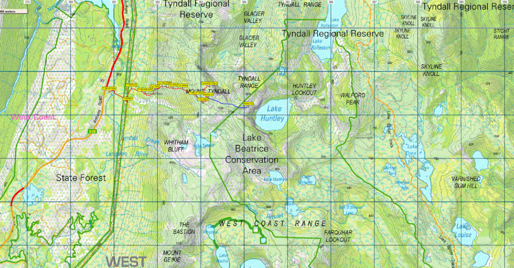
The walk to Mt. Tyndall is not particularly long - a little under 4 km from where cars are parked off the Anthony Road to the top of the mountain, but quite steep, rising from 500 metres altitude to 1100 metres over about 2 km, with a somewhat gentler few hundred metres rising a further 79 metres to reach the summit. After heading south towards the main track area, Kent will then take you a little under a km further east to Huntley lookout. This should also allow views to Lake Tyndall and the tarns and lakes that give the area its unique beauty.
This walk is rated "medium" and is suitable for walkers, including energetic and resilient older children, who have had some experience with tracks of varying quality - muddy at the start and then a very steep and rocky path, and able to keep going for sustained distances. Because of the exposed alpine conditions, walkers must be fully prepared for poor weather. Please see the warnings below.
Meeting Times and Places:
If you are interested in going on this walk, please phone your walk leader, please phone or text Kent Lillico on 0428 451 528 to book in.
Kent's meeting time and place is 9:00 am at Tullah. People coming from Launceston may prefer to travel via Sheffield and past Cradle Mountain per route below. In this case, you would need to leave Door of Hope Church car park, Launceston by 6:30 and meet Kent at Tullah, at the Wee Georgie Wood park opposite the Mt. Farrell track by 9:00 am.
If you would like to arrange to meet the group at these places or elsewhere, please arrange with the leader, and please be at any meeting place 5 minutes ahead of the listed time. The leader must be notified of any other people you intend to bring along.
To access this area from northern Tasmania: The area can be accessed from several directions, but from Launceston, proceed as if heading for Cradle Mt, the most common route being Bass Hwy past Deloraine to Elizabeth Town, then left into Railton Road, following through to Kimberley. Cross the Mersey R. bridge and turn left into Bridal Track Rd, continuing through to Sheffield. From Sheffield, go south along Claude Rd through Gowrie Park and westward down into the Forth Valley (now Cethana Rd.), continuing up the other side to Moina. Turn south into Cradle Mt. Rd. After approx. 20 km, you will reach the Cradle Mt. turnoff. Do not turn left, but continue a further 27 km or so to reach the Murchison Highway. Continue south about 20 km to reach Tullah.
If coming from the northwest: From Burnie, follow Mount St. and Ridgley Hwy south for 13 km to reach Ridgley. Continue SW for another 40 km to reach the Fingerpost Junction with Murchison Highway, near the Waratah turnoff. Follow the Murchison Hwy south a further 40 km to reach Tullah. Allow 1 hour 10 min from Burnie to Tullah.
The Anthony Road turns left about 3 km south of Tullah. The starting point for the walk is about 30 km further, but you will need to navigate using a GPS waypoint (see map and track information below), or follow the leader, to find the exact turnoff, as there are several turns to the left providing service access to a power line, including the destination turn.
Warnings:
The following codes [from our 2023 walks calendar] apply:
D Drive distance requires early departure
M Marshy or muddy sections – be prepared to walk with wet feet.
S Steep incline for at least part of the way
E Exposed alpine conditions ; can be dangerous in poor weather if not adequately equipped;
Click this link for a more detailed discussion of Preparation, Food and Safety guidelines for Boots N' All walks, and especially preparation for exposed alpine conditions.
Map details:
Mt. Tyndall: 1:100000 map is Sophia (8024) and 1:25000 map is Tyndall (3835).
Map reference: 831565
Zone Easting Northing Latitude Longitude
55G 3 83 200 53 56 650 -41.93347 145.59115
Mt. Tyndall is worth 2 peakbagger points. For listing of peakbagger points, see the Hobart Walking Club Peakbagger's Guide (2000 revision) which can be found and downloaded (as an Excel spreadsheet) from http://tastracks.webs.com/peakbaggers.htm The same web page contains several other listings of Tasmanian peaks.
GPX version of the track: Right-click here to download. Google Earth version of the track: Click here to open in Google Earth [if available on your device].
Click here to browse our entire collection of walk tracks, including to find GPX (.gpx) and Google Earth (.kml) versions of the track for this walk.
Click here to learn about using your phone as a navigation device, or to find out about handheld GPS devices.