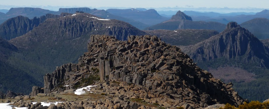
This two night camping trip will take us onto the Overland Track near its mid-point and to the summit of the highest peak in Tasmania – Mt Ossa (1617m). You must be fully self-sufficient for this walk, including tent, sleeping gear, rain gear, stove and food. A checklist of essentials is a good idea. Parks and Wildlife Tasmania have a comprehensive Safety in Parks page which covers many aspects of bushwalking safety and equipment, including a Walker Pack List that is well worth a read. However, much of this gear can be shared with a partner - perhaps a more experienced walker who already has some of the big-ticket items such as tent and stove. This area is known to have four seasons in one day, including blizzards in summer, so walkers must be prepared for anything, despite what the forecast may say.
Note also that a valid Parks Pass is needed for each vehicle, or you may have registered as an individual.
Day 1 (4-5 hours walking with full pack):
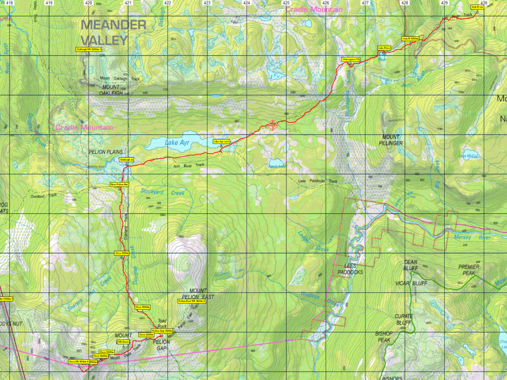
We follow the Arm River track which starts at Maggs Road in Mersey Forest. The first 500m helps to ease you into walking, before it steadily climbs up 300m elevation over the next 1.5km. This is the hardest part of today, which allows the next 9km to become a nice stroll past a variety of vegetation, lakes and mountains. There are a couple of narrow bridges to be crossed.
We will be camping next to New Pelion Hut. Only people who are booked on the Overland Track can sleep in the hut, but we can use it for cooking or sheltering from the weather if required. There are water tanks and a toilet there (bring your own toilet paper!)
Day 2 (4-6 hours walking with a day pack):
Today we will be climbing to the summit of Mt Ossa. All the gear can be left at New Pelion Hut,so just a day pack (or the hiking pack emptied out) needs to be carried up the mountain. We will follow the Overland Track and head approx. 6.5km to the summit. This track starts off gently undulating, before rapidly climbing the 760m elevation to the summit. There is some rock hopping towards the summit. We will return on the same track to the campsite.
Day 3 (4-5 hours walking with a full pack – hopefully a bit lighter than when we walked in):
Today we will be packing up and returning back along the Arm River track to the vehicle.
There is also the option, depending on time and group opinion, that we could also summit Mt Oakleigh (5km, ~3hr return to Pelion Hut) or Mt Pelion East (2.5km, ~2hr return to Pelion Gap) on Day 2.
This walk would rate as medium-hard due to the distances and the need to carry a heavy pack up a steep incline. Please discuss your level of experience with the leader.
Meeting Times and Places:
If you are interested in going on this walk, please phone Hannah Waterhouse on 0427 026 233 to book in, preferably by Wednesday night, 8th March, so that cars, tent sharing etc can be arranged. The departure time is 8:30 am from Door of Hope carpark in South Launceston. A further meeting point along the way could be 9:15 at the Train park at Deloraine. However, you still need to contact the walk leader per details above if intending to walk. The leader should be notified of any other people you intend to bring along. Please be at any meeting place 10 minutes ahead of departure time.
To access this area from northern Tasmania:
To access the area from Launceston, proceed along the Bass Highway to Deloraine (about 51 km), but do not turn off at the eastern exit into Deloraine. Instead, continue across Meander R. and up hill to the western exit, and to the roundabout at start of Mole Creek Rd. A further 24km will bring you to Mole Creek (sometimes used as a meeting place for our walks - check with leader). Continue west past Mole Creek, on what is now Liena Rd, making sure you turn south at the caravan park 4 km from the town. The road continues west until about 14 km from Mole Creek, it branches south, now called Mersey Forest Road. A little over 6 km south, you will pass turnoffs to Cradle Mountain and Devil's Gullet (Lake Mackenzie) but keep going south, crossing the Mersey at Lake Parangana and passing the turnoff for Bare Hill to reach the turnoff for Arm River (Maggs Rd), about 12 km from the Devil's Gullet turnoff. Follow Maggs Rd. (take the right hand fork 3 km in) for 16 km, first heading south, then west, and finally descending to the north, to reach the turnoff for Arm River Track. Turn left and continue for 800m to reach the car park where the walk will begin. Allow about 2 1/4 hours driving time from Launceston.
Warnings:
The following codes [from our 2023 walks calendar] apply:
E Exposed alpine conditions - can be dangerous in poor weather if not fully equipped - see below.
S Steep incline for at least part of the way
B Boulder field – walkers need to be able to confidently step from rock to rock.
This walk is over 900 metres altitude from the first hour, and rises to over 1600m for the much of the distance and can be very exposed if the weather is bad, even at this time of year. Be prepared! Walkers should wear sturdy footwear due to uneven surfaces, and gaiters for mud, rough vegetation and snakes. You should always carry wet weather gear as well as warm clothing in case of sudden weather changes. For equipment guidelines, CLICK HERE.
Map details:
Mt Ossa: 1:100000 map is Sophia (8014) and 1:25000 map is Achilles (4036).
Map reference: 196639
Zone Easting Northing Latitude Longitude
55G 4 19 750 53 64 125 -41.87072 146.03296
Maps for other locations (still on Sophia): Car park - Rowallan 4237 , Mt. Oakleigh - Will 4037, New Pelion Hut and Mt Pelion East - Cathedral 4236
Mt. Osssa is worth 4 peakbagger points. If the group should happen to find the energy and time, Mt. Pelion East is worth 2 points and Mt. Oakleigh 3 points. For listing of peakbagger points, see the Hobart Walking Club Peakbaggers' Guide (2000 revision) which can be found and downloaded (as an Excel spreadsheet) from http://tastracks.webs.com/peakbaggers.htm The same web page contains several other listings of Tasmanian peaks.
For GPX (.gpx) and Google Earth (.kml) versions of the track: Click here to browse our collection.
Direct links: GPX for this walk KML for this walk
Right-click on the file and save target as to a location of your choice. (Suggest you click the Last modified at top to sort by date to get the most recent at top to find the file for the next walk).