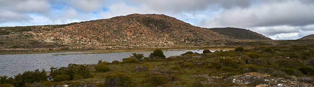
No, this is NOT an April Fool's joke! Last visited by Boots N' All in 2017, the area had been badly scorched by bushfires in 2016, so it will be interesting to see to what extent the vegetation is growing back. That said, there are extensive areas around the route that were spared. Fisher Bluff is a peak in the Lake Mackenzie area that offers great views of the Little Fisher River area, Mersey Crag, Turrana Bluff, Walls of Jerusalem, Clumner Bluff and other well-known landmarks. It involves a tracked walk at the beginning followed by off track walking to the summit and back through beautiful alpine terrain across grass, ferns and small rocks, around pools, tarns and lakes and past pencil pine forests. It is rated moderately hard because of the distance and also the off-track section where it can be uneven underfoot.
Walk route:
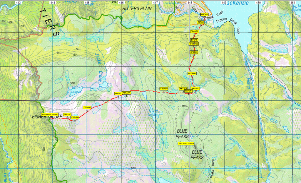
From the car park at Lake Mackenzie, already 1100m altitude, we walk around the boom gate, along the road, across a bridge and soon leave the road to follow the Blue Peaks track for 2.6 km, taking about one hour, and climbing about 150m. We then head west and begin the off track part of the walk. For about two hours we traverse 4 km over gentle rises and open valleys, rising about a further 100m until we come to a lovely pencil pine forest at the base of the bluff itself. From here we begin the final approach, taking about 30 mins to cover the 50 m climb and 1 km distance to the high point at just over 1400 m altitiude. We will most likely return the same way. Total return walk distance is approximately 16 km.
Meeting Times and Places:
If you are interested in going on this walk, please phone Darren Wunder on 0438 557 046 to book in.
If coming from the northwest, Meet Darren 7 am at Hiscutt Park, Crescent Street Penguin. See below for directions.
If coming from Launceston, the departure time is 7:30 am from Door of Hope carpark in South Launceston. Meeting points along the way could be 8.00 at the Mole Creek Road roundabout at the western end of Deloraine, 8.20 at Mole Creek or 8.35 at the Lake Mackenzie (Devil's Gullet) Road junction with the Mersey Forest Road. However, you still need to contact the walk leader per details above if intending to walk. The leader should be notified of any other people you intend to bring along. Please be at any meeting place 5 minutes ahead of departure time.
To access this area from north-west Tasmania:
Meet Darren 7 am at Hiscutt Park, Crescent Street Penguin by taking the right hand turn straight after the traffic lights if coming from Burnie or off the Bass Highway. A pond and windmill make it easy to spot. Allow a little over 1 hour from Penguin to Mole Creek, whether coming via Bass Highway and Deloraine, or via Sheffield and Paradise Rd/Union Bridge Rd.(C137) which is shorter but more winding. Either way, you still turn south at the caravan park 4 km west of Mole Creek, which is in fact where Union Bridge Rd. comes through. See below for rest of route.
To access this area from northern Tasmania:
From Launceston, proceed along the Bass Highway to Deloraine (about 51 km), but do not turn off at the eastern exit into Deloraine. Instead, continue across Meander R. and up hill to the western exit, and to the roundabout at start of Mole Creek Rd. A further 24km will bring you to Mole Creek (sometimes used as a meeting place for our walks - check with leader). Continue west past Mole Creek, on what is now Liena Rd, making sure you turn south at the caravan park 4 km from the town.
The road continues west until about 14 km from Mole Creek, it branches south, now called Mersey Forest Road. A little over 6 km south, you will pass a turnoff to Cradle Mountain and Sheffield, and about 300 metres further, take the turn on left to Devil's Gullet/Lake Mackenzie. Follow this road about 19 km, and just short of the Lake Mackenzie dam, turn south to find the car park and boom gate from where the walk starts.
Warnings:
D...Drive distance requires early departure – 7 or 7:30 am (see above)
E...Exposed alpine conditions – can be dangerous in poor weather if not fully equipped.
L...A long day’s walk – in excess of 3 hours each way.
Make sure you have a good supply of drinking water - suggest 1 litre per person, although there should be drinkable water in the area. Walkers are advised to wear strong shoes or boots. Gaiters recommended due to off-track walking. You should always carry wet weather gear as well as warm clothing including gloves and beanies in case of sudden weather changes. This walk is above 1100 metres altitude for the whole distance and can be very exposed if the weather turns bad. Be prepared!
Click this link for a more detailed discussion of Preparation, Food and Safety guidelines for Boots N’ All walks.
Map details: Fisher Bluff: 1:100000 map is Tasmap 8114 (Mersey) and 1:25000 map is 4438 (Lake Mackenzie)
Map reference:
Short ref. 438823
Zone Easting Northing Latitude Longitude
55G 4 43 920 53 82 490 -41.70740 146.32593
Fisher Bluff is worth 1 peakbagger point. For listing of peakbagger points, see the Hobart Walking Club Peakbagger's Guide (2000 revision) which can be downloaded (Excel) from http://tastracks.webs.com/peakbaggers.htm The same web page contains several other listings of Tasmanian peaks.
GPX version of the track: Right-click here to download. Google Earth version of the track: Click here to open in Google Earth [if available on your device].
Click here to browse our entire collection of walk tracks, including to find GPX (.gpx) and Google Earth (.kml) versions of the track for this walk.
Click here to learn about using your phone as a navigation device, or to find out about handheld GPS devices.