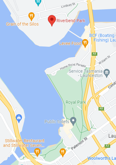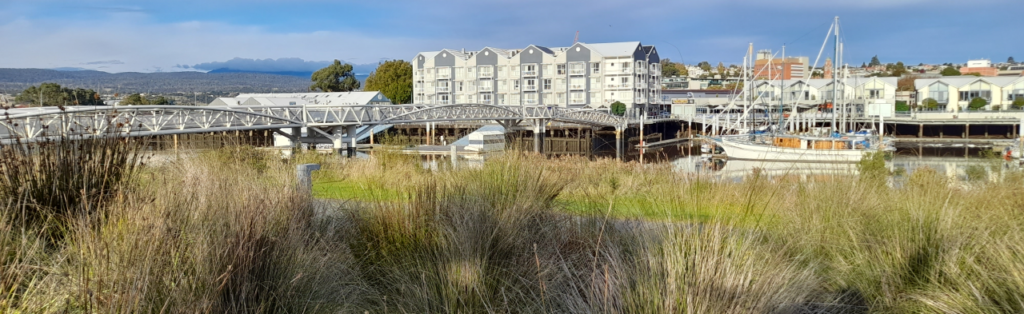
The North Esk and South Esk Rivers meet to form kanamaluka/River Tamar, the main river in the North-East of Tasmania. The confluence of these rivers is a picturesque location for a walk, with many beautiful vistas enhanced by the reflections off the river. New development in this area has made it a popular place for exercise, eateries and accommodation. Our walk will incorporate a number of locations in this precinct including Riverbend Park, The Silos Hotel, North Bank Pedestrian Bridge, The Seaport and Boardwalk, The Lions Endeavour Playground, Kings Park, Royal Park and the East Tamar Highway Bridge.
Walking Route:
We will start at the Riverbend Park carpark at 2pm, meeting in front of the large entrance structure. Circling around the back of the Silos Hotel, we then take the gravel track which leads to the North Bank Pedestrian Bridge. Once across the bridge, we follow the boardwalk to the Lions Endeavour Playground and continue on to Kings Park, returning to the playground where we will take some time for the children to play (adults may also like to use the fitness station). We will take a different route back to Riverbend Park, heading up Park Street and then through the centre of Royal Park, and crossing the Charles St. Bridge. The kids will again have an opportunity to play once we return to Riverbend Park. The total loop is about 3 km which is one of our shorter walks this year, so we may be finished earlier than the normal 4pm finish time. This will give ample time for the kids to have a longer play time at Riverbend Park.
Meeting Times and Places:
If you are interested in going on this walk, please phone Jonno Burgess on 0455 463 809 to book in. We will be meeting at the Riverbend Park carpark at 2pm.
Unlike the regular Boots N’ All walks which often visit more challenging wilderness areas, there is no particular need to register in advance for these Sunday afternoon Family Fun Walks. Your walk leader would nevertheless appreciate if you could let him know you are coming, so that the walk doesn’t set off without you.
To access this area from northern Tasmania:
From the city centre of Launceston, either head northeast along Cimitiere Street, turning left onto Tamar Street and heading over the bridge. Once across the bridge, turn left into Lindsay Street, continuing past the traffic lights. The River Bend Car Park is the first turn on your left after the traffic lights. Alternatively, head South-West along York Street, turning Left into Wellington Street and ensuring you are in the left lane. Wellington Street transitions into the East Tamar Highway and once you cross the bridge, turn left into Lindsay Street and then take your first left turn into the Riverbend Park Car Park. Those familiar with Launceston will no doubt be aware of other ways to get there.
Other Information:
These Sunday afternoon walks do not require the level of preparation and equipment needed for wilderness walks. Dress comfortably and sensibly, and remember that even over a 2-hour period, weather can be changeable in northern Tasmania, so it’s always a great idea to have a warm top and a raincoat in your backpack, along with a drink and perhaps a snack.
The surfaces for this walk vary from gravel, bitumen, pavers and the 'Enduroplank' decking of the board walk, with a few gentle up and down sections. The circuit we will take is suitable for strollers and pets (although pets are technically not allowed inside Riverbend Park). There are toilets at both Riverbend Park and near the Lions Endeavour Playground. We will be trialling a kids activity as part of this walk and will also have a conversation starter for the adults.
We will need to cross a few driveways and quieter streets and there are also a few short sections where we walk next to busy roads. Parents will need to supervise their children carefully at these points and as a group we will need to stay alert and work together so we can all navigate these areas safely.
Map: