You are probably aware that John had planned a trip to Lake Lucy Long on 20th May, but that area of Central Plateau will be closed throughout May due to TWWHA deer culling, so we are being taken to another of John's favourite areas on the northern edge of the plateau, but starting from Lake Mackenzie instead of Higgs Track.
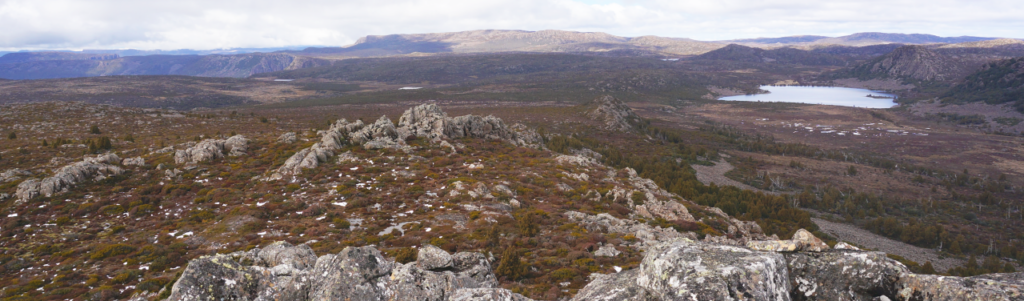
With winter only a couple of weeks away, the weather on the high plateau will likely be cold, perhaps frosty, but hopefully sunny. Caveside Prospect, as the name suggests, offers extensive views across northern Tasmania as far as Bass Strait, but also south into a land of lakes and peaks and areas of open alpine vegetation. Sights should include Lake Balmoral, Panorama Hill and a broad expanse of higher peaks from Ironstone Mountain around to Blue Peaks and beyond. The route passes through a variety of alpine vegetation, but there are expanses of low alpine vegetation which should make for comfortable walking. It should be possible to visit the relatively new Sandy Lake Hut, which was rebuilt over the past few years. The original hut had been "drowned" by the raising of the Lake Mackenzie dam in the 1960s. Energetic and resilient children should be able to manage this walk, but the shorter daylight hours will necessitate a reasonable pace.
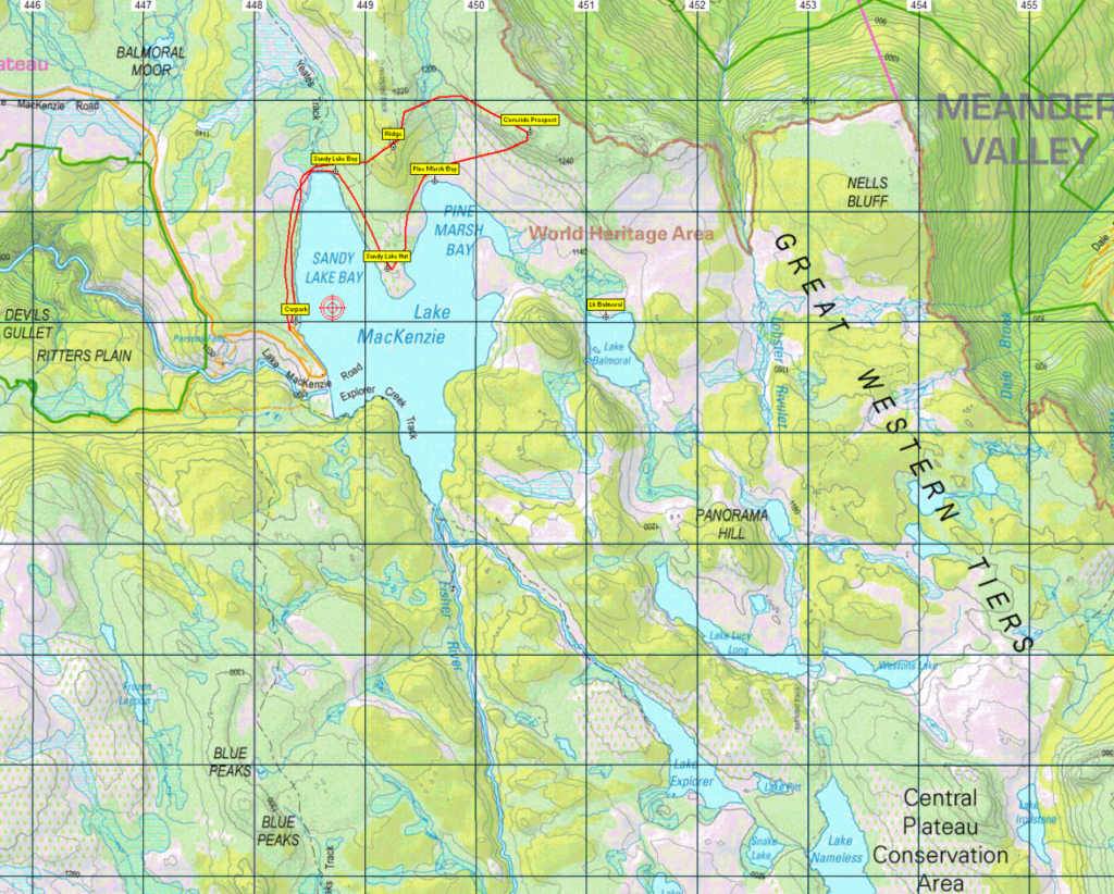
Walk route:
From the car park at the northern end of the Lake Mackenzie dam, alt. 1120m, the route heads north following Yeates Track along the shore of the lake for a little over 1 km, before swinging east and northeast, climbing steadily over the next km to cross a ridge (alt. 1200m) and following the contours southeast 1.5 km to reach the high point of Caveside Prospect (alt. 1290m). Descending southwest, the northern end of Pine Marsh Bay is passed after 1 km. If time permits, the shore of the bay will be followed south for a little under 1 km to reach Sandy Lake Hut. Leaving the hut, we head about 1 km northwest to reach the head of Sandy Lake Bay before retracing our earlier route for about 1 km to reach the carpark. Total return distance if the hut is visited is about 9 km, but could be more if conditions are good and the party is energetic. Please note: the linked tracks (below) are notional routes, and the actual route followed may vary depending on obstacles and conditions.
Meeting Times and Places:
If you are interested in going on this walk, please phone or text your walk leader, John Tabor, ph. 0475 566 389 to book in. The departure time is 7:30 am from Door of Hope car park or at Deloraine Train Park about 8 am. Other meeting points along the way could be 8.25 at Mole Creek or 8:40 at the Lake Mackenzie (Devil’s Gullet) Road junction with the Mersey Forest Road. If you would like to arrange to meet there or elsewhere, please arrange with the leader, and please be at any meeting place 5 minutes ahead of the listed time. The leader must be notified of any other people you intend to bring along.
To access this area from northern Tasmania:
To reach the area from Launceston, proceed along the Bass Highway to Deloraine (about 51 km), but do not turn off at the eastern exit into Deloraine. Instead, continue across Meander R. and uphill to the western exit, and to the roundabout at start of Mole Creek Rd. A further 24km will bring you to Mole Creek. Continue west past Mole Creek, on what is now Liena Rd, making sure you turn south at the caravan park 4 km from the town. The road continues west until about 14 km from Mole Creek, it branches south, now called Mersey Forest Road. A little over 6 km south, you will pass a turnoff to Cradle Mountain and Sheffield, and about 300 metres further, take the turn on left to Devil’s Gullet/Lake Mackenzie. Follow this road for about 19 km to reach the carpark at the northern end of Lk Mackenzie dam, which is where the walk starts.
Warnings:
The following codes [from our 2023 walks calendar] apply:
D Drive distance requires early departure
M (depending on off-track sections) Marshy or muddy sections be prepared to walk with wet feet.
E… Exposed alpine conditions – can be dangerous in poor weather if not fully equipped.
This walk is above 1100 metres altitude for the whole distance and can be very exposed if the weather is poor. Be prepared! Walkers should wear sturdy boots due to uneven surfaces. Gaiters recommended due to off-track walking. You should always carry wet weather gear as well as warm clothing in case of sudden weather changes. For equipment guidelines, CLICK HERE.
Map details:
Caveside Prospect (alt. 1290 m): 1:100000 map is Tasmap 8114 (Mersey) and 1:25000 map is 4438 (Lake Mackenzie).
Map reference:
Short ref. 479815
Zone Easting Northing Latitude Longitude
55G 4 50 470 53 87 680 -41.661095 146.405086
For the peakbaggers, No peakbagger points will be reached on this walk. For listing of peakbagger points, see the Hobart Walking Club Peakbagger’s Guide (2000 revision) which can be downloaded (Excel) from http://tastracks.webs.com/peakbaggers.htm The same web page contains several other listings of Tasmanian peaks.
For GPX (.gpx) and Google Earth (.kml) versions of the track: Click here to download.
Direct links: GPX for this walk … KML for this walk
Right-click on the file and save target as to a location of your choice. (Suggest you click the Last modified at top to sort by date to get the most recent at top to find the file for the next walk).