This two-night camping trip will take us around the Freycinet Peninsula, where we will explore some of Tasmania’s most famous beaches. You must be fully self-sufficient for this walk, including tent, sleeping gear, rain gear, stove and food. Due to unreliable water at the second campsite, it’s recommended that you have the ability to carry sufficient water for two days of walking and cooking (drink bottles/water bladder with a minimum 3L capacity). Due to the distances and the need to carry a fairly heavy camping backpack, a reasonably good level of fitness is required. The walk has been part of SU's Taking on Goliath expeditions for older children and teens, so it is achievable for younger participants, but anyone under 18 would need to be accompanied by a parent or responsible adult.
Day 1 (12km, 3.5 hours easy walking)
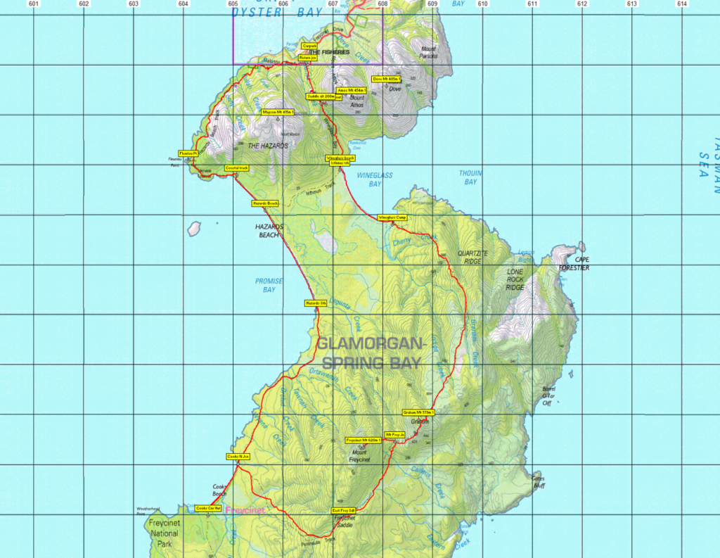
The first day will see us following Hazards and Cooks Beach around the headland, travelling in and out of forests and along the sand. The campsite is located at the southern end of Cooks Beach and has a toilet and a water tank.
Day 2 (11km, 6-8 hours medium walking)
Today is the most challenging day as we will be climbing up and over Mount Graham. There is a total climb of 500 metres elevation before descending back to the coastline. The track meanders through forests and buttongrass moorlands, and offers some incredible views as you climb higher. The Wineglass Bay campsite also has a toilet.
There is the option of summiting Mount Freycinet as a side trip. Mount Freycinet is the highest summit on the peninsula. Packs can be dropped at the side of the track before following it for a 1.5km, 2hr return trip. This climb can be steep and difficult, but will reward you with beautiful views.
The drinking water is not reliable at the Wineglass Bay campsite, so we will need to fill up everything at Cooks Beach and carry it for the day.
Day 3 (4km, 1.5 hours medium walking)
The last day only involves a short distance back to the car. We will be walking along the entire length of Wineglass Bay beach, before ascending up the stairs over the Hazards saddle and down to the carpark.
Meeting Times and Places:
If you are interested in going on this walk, please phone Hannah Waterhouse on 0427 026 233 to book in, preferably by Wednesday night 7th June, so that cars, tents etc can be arranged. The departure time is 9:30 am from Door of Hope carpark in South Launceston. Additional meeting points can be arranged if needed. The leader should be notified of any other people you intend to bring along. Please be at any meeting place 10 minutes ahead of departure time.
To access this area from northern Tasmania: From Launceston, follow the southern outlet and Midland Highway for 70 km to Campbell Town and continue across the Red Bridge to the junction of the Lake Leake Highway (B34) near the southern outskirts of the town. Turn left and follow B34 for 60 km right through to the Tasman Highway (A3) junction. Turn left and head north and then north-east along the Tasman Highway for 22 km to reach the Coles Bay Road (C302). Follow Coles Bay Rd for 26 km to reach Coles Bay, and continue through to the Freycinet car park, a further 5 km. Total distance 180 km, and allow 2 hours 10 minutes drive time.
Warnings:
The following codes [from our 2023 walks calendar] apply:
S Steep incline for at least part of the way
L A long day’s walk – about 12 km all up
Please take note of the weather forecast fo. Make sure you bring drinking water – see notes above. Walkers are advised to wear sturdy boots. Gaiters provide extra protection from vegetation, insects and cold. Heavier gaiters with under-foot straps can also protect against sprains.
You should always carry wet weather gear as well as warm clothing in case of sudden weather changes.
Click this link for a more detailed discussion of Preparation, Food and Safety guidelines for Boots N’ All walks, and especially Walker Pack List for camping trips.
Map details and references:
For the Wineglass Bay circuit, 1:100000 map is Freycinet (Tasmap 8513) and 1:25000 maps are Coles Bay (TasMap 6033) and Graham (Tasmap 6032)
Mt. Graham: Short ref. 086256
Zone Easting Northing Latitude Longitude
55G * 6 08 720 * 53 25 890 * -42.21160 * 148.31713
Mt. Freycinet: Short ref. 075252
Zone Easting Northing Latitude Longitude
55G * 6 07 610 * 53 25 340 * -42.21670 * 148.30378
Mt. Graham and Mt. Freycinet are worth 1 peakbagger point each. For listing of peakbagger points, see the Hobart Walking Club Peakbagger’s Guide (2000 revision) which can be downloaded (Excel) from http://tastracks.webs.com/peakbaggers.htm The same web page contains several other listings of Tasmanian peaks.
Downloadable tracks for your navigation devices, including mobile phones: GPX track for this walk … KML track for this walk
Click here to browse our entire collection of walk tracks, including to find GPX (.gpx) and Google Earth (.kml) versions of the track for this walk.
Click here to learn about using your phone as a navigation device, or to find out about handheld GPS devices.