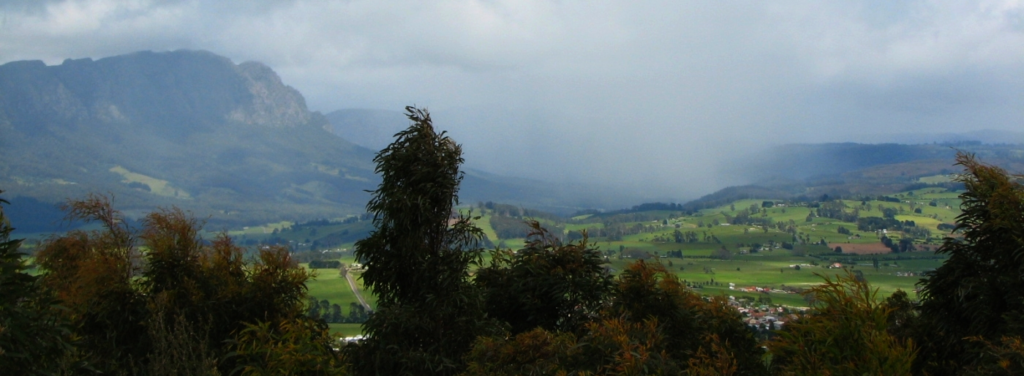
Close as it is to midwinter, July is a great time for a shorter walk away from the really high country, with the potential for a coffee break on the way home. Kimberleys Lookout is just over 3 km north of Sheffield, and offers great views towards Mt Roland and the Cradle area (weather permitting). It can be a very short walk (4 km return) but we will extend by exploring a trail a little to the north - for the exercise!
If time and interest permit, we should be able to stop at the little known but impressive Dasher Gorge on the way home - just metres from Bridle Track Rd, there was once a lookout, but it was removed many years ago.
Walk Route:
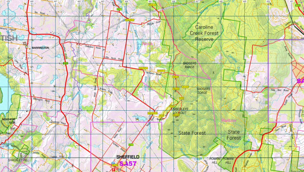
If a car shuttle is possible, the walk will begin at Jarmans Rd, about 6 km out of Sheffield, about 300m altitude, heading east for 0.5 km and turning south to reach Timms Lookout, alt. 400m. From there, we will follow the ridge of Badgers Range south for a little over 1 km via a high point (alt. 480m), southeast to a further rise where we meet the track from the Kimberleys Lookout carpark, and continuing south for a further 1 km, rising to 551m at the summit of Kimberleys Lookout. We turn back from there, heading north to the junction, and descending to the Kimberleys Lookout carpark. (If car shuttle isn't possible, we go up from Kimberleys LO carpark, north along an old road to Timms LO, and then south along the skyline traverse to Kimberleys LO - about 1 km longer). This walk is suitable for energetic children and people of reasonable fitness (steep climbing in places). Total walk distance is about 6 km.
If the party is small, and capable of moving faster, the walk could begin even further north at Morgans Rd. to include the entire Badgers Range skyline traverse. This option would be about 8.5 km.
Meeting Times and Places:
If you are interested in going on this walk, please phone your walk leader, Grace Hillman, ph. 0490 840 866 to book in. The departure time is 9:00am from the Door of Hope Church car park, Launceston. Suggested meeting place if coming from elsewhere could be Sheffield at High St/Nook Rd. turnoff at 9:50 am (at carpark off High St/Nook Rd. just behind shops). If you would like to arrange to meet the group at these places or elsewhere, please arrange with the leader, and please be at any meeting place 5 minutes ahead of the listed time. The leader should always be notified of any other people you intend to bring along, and you should always contact the walk leader if intending to participate in a particular Boots N' All walk.
To access this area from northern Tasmania: From Launceston, follow Bass Hwy for 60 km, past Deloraine and turn left just short of Elizabeth Town into into Railton Road (B13), following for 12 km to Kimberley. Just past Kimberley and across the bridge, turn left into Bridal Track Rd (C156) and follow for 11km to turn left into Sheffield Rd (B14), continuing a further 4.6 km to reach the junction of Nook Rd (C150) in the centre of Sheffield. Turn northeast into High St. which becomes Nook Rd. and continue for 2.7 km to reach the junction of Badgers Rd. After noting this junction, continue for 2.6 km on Nook Rd, past a sharp bend to left, then another to the right, to reach Jarmans Rd. Turn right and continue about 700m to reach the carpark. The walk starts from here, but first, drivers will need to shuttle cars back to Badgers Rd and the Kimberleys Lookout carpark.
Warnings:
The following codes [from our 2023 walks calendar] apply:
S Steep incline for at least part of the way
Boots or strong shoes recommended. You should always carry wet weather gear as well as warm clothing in case of sudden weather changes. For equipment guidelines, CLICK HERE.
Map details:
Kimberleys Lookout: 1:100000 map is Forth (Tasmap 8115) and 1:25000 map for upper area is Railton (TasMap 4442).
Map reference:
Short ref. n.a.
Zone Easting Northing Latitude Longitude
55G 4 46 090 54 20 700 -41.36340 146.35544
No peakbagger points will be reached on this walk. One list includes Kimberleys Lookout as an "Abelette". For listing of peakbagger points, see the Hobart Walking Club Peakbagger's Guide (2000 revision) which can be downloaded (Excel) from http://tastracks.webs.com/peakbaggers.htm The same web page contains several other listings of Tasmanian peaks.
GPX version of the track: Right-click here to download. Google Earth version of the track: Click here to open in Google Earth [if available on your device].
Click here to browse our entire collection of walk tracks, including to find GPX (.gpx) and Google Earth (.kml) versions of the track for this walk.
Click here to learn about using your phone as a navigation device, or to find out about handheld GPS devices.