After a short visit to a less well known but interesting high point near Gunns Plains in the hinterland of the northwest coast of Tasmania, we explore waterfalls and the magnificent Leven Canyon. The day consists of three, and maybe four, short walks, but plenty of exercise between the driving.
Walk Routes:
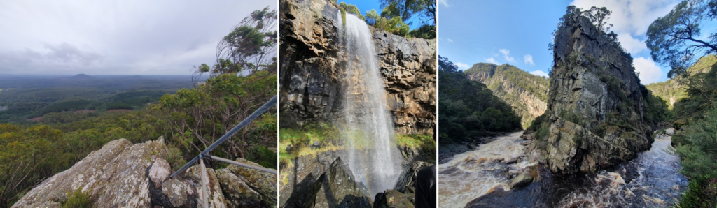
Loyetea Peak follows an old fire trail from Loyatea Rd to an old car park. From the carpark (alt.486m), it is a brisk but otherwise fairly easy rock scramble to the peak (alt. 705m). Views over Black Bluff, out to the Coast and Gunns Plains. The track is steep with fallen trees to negotiate.
Preston Falls (aka Delaneys Falls) is an easy walk, under 200m each way, along a graded track with steps. A side walk to the base of the falls is extremely steep and slippery but is well worth the effort for a different perspective of the falls.
Upper Preston Falls follows a narrow track for 5 mins - again under 200m each way. Slippery when wet but falls are worth it. More adventurous people can venture across the slippery rocks to the other side of the creek and walk behind the falls.
The Leven Canyon floor walk starts down a well graded track with about 270 steps to the river. The track then becomes narrow slippery and steep with steep drops to the river. Views of the surrounding cliffs and swirling water of the Leven River. Total distance about 3 km return.
The walks are all suitable for energetic and sure-footed younger children, and moderately fit adults. An option for the not-so-fit might be to remain at the cars while others do the climbing at Loyatea Peak, and similarly to take a much shorter walk to the footbridge at Leven Canyon, by negotiation with the leader, who would be accompanying the main group.
Meeting Times and Places:
If you are interested in going on this walk, please phone Darren Wunder on 0438 557 046 to book in. Meet 9 am at Hiscutt Park, Crescent Street Penguin by taking the right hand turn straight after the traffic lights if coming from Burnie or off the Bass Highway. A pond and windmill make it easy to spot. Please negotiate any alternative travel arrangements with the leader. You must contact the walk leader per details above if intending to join this walk. The leader should be notified of any other people you intend to bring along. Please be at any meeting place 5 minutes ahead of departure time.
Those coming from Launceston area should meet at Door of Hope southern carpark at 7:30 am. Check with Darren about who to meet there.
To access this area from Burnie: Follow the Bass Highway east from Burnie, turning off at Howth to follow the coastal road to reach the meeting place - 16 km. If coming from Devonport, its 22 km via the Bass Highway. Take the second exit off the highway, turn right at the traffic lights and the right turn straight after gets you to Hiscutt Park. An hour and a half from the middle of Launceston (130 km) is ample time to make it to Penguin.
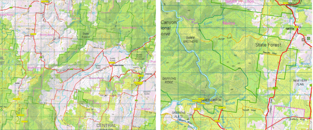
To access the first walk from Penguin, head 17.5 km south via Pine Rd (B17) to South Riana. Turn left into South Riana Rd (still B17) and follow for 3 km before turning right into Loyetea Rd. Follow Loyetea Rd. south for 6 km to reach Loyetea Peak Rd. Turn left and follow for 1.5 km to reach the carpark.
From there to the next walk, retrace Loyetea Rd to rejoin South Riana Rd, turning right and 10 km continuing south, then east and south again, to Gunns Plains. Cross Gunns Plains Rd to continue south, then east, in Raymond Rd. for just over 4 km to reach the Preston Falls reserve.
For the next walk, continue south in Raymond Rd for just under 1 km to reach Preston Rd (C125) and turn right. Continue south for 10.5 km to reach Nietta. Turn right into Loongana Rd (C128) and head south, then west for 8 km to reach the first Leven Canyon turnoff. This is to the upper lookout, with a car park about 400 metres in. However, the lower walks begin another km west along Loongana Rd.
Should you wish to meet the party at any of those locations, please check with Darren when registering for the walks.
Equipment and Warnings:
Bring sturdy shoes, wet/cold-weather gear (It's still winter, and Tasmania's weather can vary greatly), plenty of water, lunch and snacks. Optional: trekking poles, gaiters and camera
The following codes [from our 2023 walks calendar] apply:
S Steep incline for at least part of the way
For equipment and safety guidelines, Click Here.
Map details:
Loyetea Peak: 1:100000 map is Tasmap 8015 (Inglis) and 1:25000 map is 4042 (Loyetea)
Map references:
Short ref. 126254
Zone Easting Northing Latitude Longitude
55G 4 12 730 54 25 490 -41.31734 145.95732
Loyetea Peak (alt. 705m) is worth 1 peakbagger point. For listing of peakbagger points, see the Hobart Walking Club Peakbaggers Guide (2000 revision) which can be downloaded (Excel) from http://tastracks.webs.com/peakbaggers.htm The same web page contains several other listings of Tasmanian peaks.
For GPX (.gpx) and Google Earth (.kml) versions of the track: Click here to browse our collection.
Direct links: GPX for this walk : KML for this walk [note that the files for this walk are mostly waypoints, except for Leven Canyon Floor walk.
Right-click on the file and save target as to a location of your choice. (Suggest you click the Last modified at top to sort by date to get the most recent at top to find the file for the next walk).