Liffey Falls is a well-known and quite impressive waterfall attraction not far from Launceston. It is only a short walk from the upper car park. Even from the lower car park it is still only about one hour's walk each way. Depending on the energy and enthusiasm of the participants on the day, it should be possible not only to visit the main falls, but to explore further upstream for more wilderness delights. This walk is rated easy-medium (some steep sections). Reasonably fit adults and energetic children should be able to manage it.
Walk route:
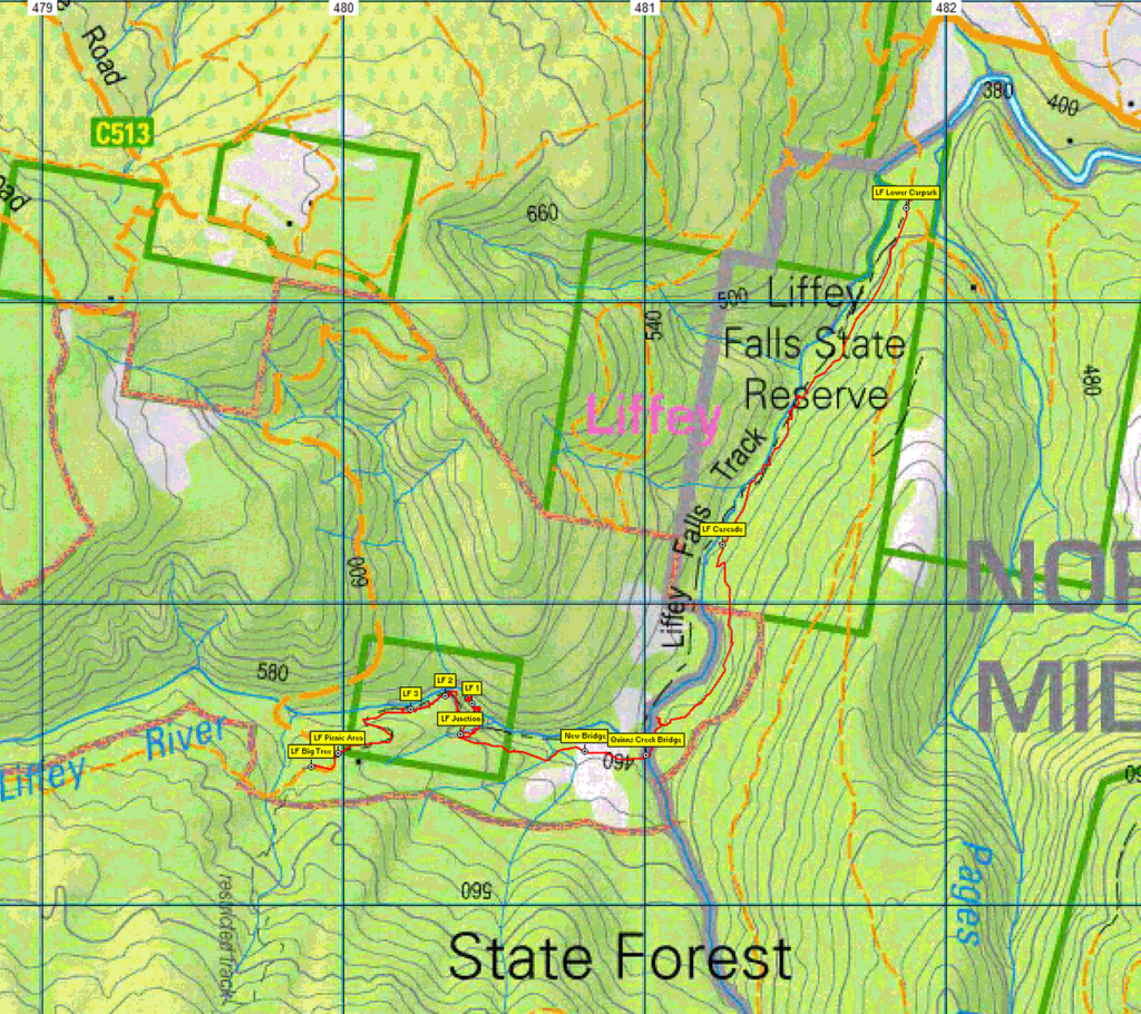
The walk starts at about 400 m altitude at the lower Liffey Falls car park and picnic area at Liffey near Bracknell. The recently re-opened track will be followed 3 km upstream to the main falls. After enjoying the beautiful falls for as long as people would like, the track is followed back about 150 m to a junction where it continues steeply uphill for about 150 m to reach firstly the top of the main falls (alt. 500 m), then a second and third waterfall, each no more than about 100 m upstream from the previous one. Another 400 m brings the track to the top carpark, and just beyond that, the Big Tree - a stringybark eucalypt about 50 metres high - well worth a look. The walk then retraces the track down past each waterfall and downstream, returning to the lower carpark.
Total walk distance if the Big Tree is reached, is 9 km return.
Meeting Times and Places:
If you are interested in joining this walk, please phone or text the leader, Grace Hillman, on 0490 840 866. The departure time is 9:30 am from Door of Hope carpark in South Launceston. We should expect to be back in Launceston by around 4.00 pm. If you would like to arrange to meet elsewhere, please arrange with the leader, and please be at any meeting place 5 minutes ahead of the listed time. The leader must be notified of any other people you intend to bring along.
To access this area from northern Tasmania:
From Launceston, head towards Deloraine on the Bass Highway, and after travelling about 20 km take the Oaks Road (C511) turn off to the left which is marked Liffey Falls. After travelling another 11 km you will reach a 4 way junction in the centre of Bracknell. Turn right here onto C513 and follow this as it joggles left, then right then left again until you reach the little town of Liffey after a further 7 km. Turn right here to follow C513 for 9.5 km until you see the sign for the turn off to the Campground to the left. (At this point do NOT follow the signs straight ahead to Liffey Falls as this refers to the upper car park). Follow the road to the left for about 700m until you get to the lower car park which is where our walk starts.
Warnings:
S... Steep incline for at least part of the way
You should carry wet weather gear as well as warm clothing in case of sudden weather changes. Walkers should carry water with them, suggest 1 litre. Also bring your lunch and snacks.
For equipment and safety guidelines, Click Here.
Map details:
No peakbagger points will be visited on this walk. See The Peakbaggers Points List, which can be downloaded (Excel) from http://tastracks.webs.com/peakbaggers.htm which contains the 1983 and 2000 versions, developed from the original 1968 Hobart Walking Club version. A parallel and more recent but not identical list system is The Abels - also available on the same website, which contains some other listings of Tasmanian peaks.
For GPX (.gpx) and Google Earth (.kml) versions of the track: Click here to browse our collection.
Direct links: GPX for this walk ... KML for this walk
Right-click on the file and save target as to a location of your choice. (Suggest you click the Last modified at top to sort by date to get the most recent at top to find the file for the next walk).