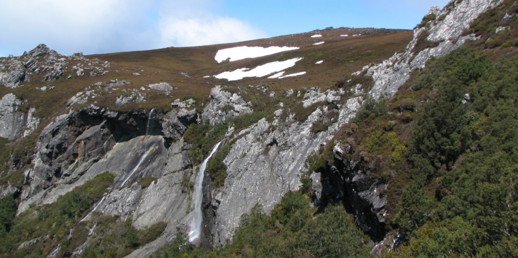
Quite close to the impressive Black Bluff that dominates the hinterland behind Ulverstone, Winterbrook Falls drops 200m off the side of the range in three cascades. A previous Boots N' All walk used the falls walk as an access to Black Bluff, about 1.7 km from the falls, but a considerable climb - about 400 m higher than the top of the falls! We are not so ambitious this time, especially as the track is about 700 m longer each way nowadays, due to the collapse of a bridge.
Walk Route
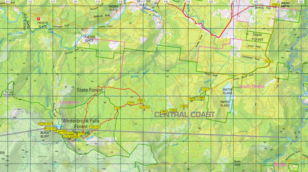
The walk begins from old logging roads south of South Nietta. It follows a historical horse-drawn logging tramway and former logging tracks west, then southwest, and there are some remnants of the logging industry. The track is relatively flat for the first 2.5 km of the walk, before climbing fairly steeply southwest, then west for the next 1.5 km. A viewing point about 400m short of the falls gives a great view of the falls and the alpine escarpment above the treeline. The bottom of the lower falls (alt. 860m) is reached before the track rises to the base of the next cascade (alt. 910m). Total walk distance is 9 km return, if the same route is followed, although there is an alternative northern route back to the car which adds another 2 km to the walk. Due to the steep and somewhat rugged ascent near the falls, the walk is rated as medium, and requires moderately good fitness. Energetic children should enjoy the walk.
Meeting Times and Places:
If you are interested in joining this walk, please phone or text the leader, Basil Tkaczuk, on 0438 664 402. The departure time is 8 am from Door of Hope carpark in South Launceston. Suggested meeting places if coming from elsewhere are the train park at Deloraine, or the junction at Gawler. If you would like to arrange to meet the group at these places or elsewhere, please arrange with the leader, and please be at any meeting place 5 minutes ahead of the listed time.
The leader should always be notified of any other people you intend to bring along, and you should always contact the walk leader if intending to participate in a particular Boots N' All walk.
To access this area from northern Tasmania: From Launceston, proceed along the Bass Highway, through Devonport, to Ulverstone – 120 km. Turn off the highway at the exit to Gawler (B17). Continue south about 1.5 km and take the right branch at Gawler. Continue on B17 for just under 8 km, then left into Preston Road, C125, continuing through Preston and South Preston to Nietta.
Alternatively, Google Maps suggests from Gawler, take Top Gawler Rd (C123) to Sprent, then turn right into Castra Rd. (B15) to Nietta – just under 29 km from Gawler. This may be the preferable route.
At Nietta, take the left fork and continue south on Smiths Plains Rd (C129) for 7 km through South Nietta, and follow the road as it swings right, continuing a further 6 km through old logging roads, hopefully signposted, to reach a point where the road is no longer driveable. Park in the quarry on right. Total distance from Ulverstone is 47 km. Allow about 2 hours drive from Launceston.
Warnings:
S… Steep incline for at least part of the way - ascent can be quite rough in a couple of places, and fallen trees might need to be clambered over.
You should carry wet weather gear as well as warm clothing in case of sudden weather changes. Walkers should carry water with them, suggest 1 litre. Also bring your lunch and snacks.
For equipment and safety guidelines, Click Here.
Map details:
Winterbrook Falls: 1:100000 map is Inglis (Tasmap 8015) and 1:25000 map for upper area is Loongana (TasMap 4041).
Map reference:
Short ref. n/a
(for Black Bluff)
Zone Easting Northing Latitude Longitude
55G 4 12 670 54 10 640 -41.45107 145.95446
While there are no peakbagger points for the section covered by the intended walk, Black Bluff, as mentioned above, is close by, and is worth 2 peakbagger points. Surprisingly, it is not an Abel, the honours being held by the Black Bluff Range high point, further south. For listing of peakbagger points, see the Hobart Walking Club Peakbagger's Guide (2000 revision) which can be found and downloaded (as an Excel spreadsheet) from http://tastracks.webs.com/peakbaggers.htm The same web page contains several other listings of Tasmanian peaks.
For GPX (.gpx) and Google Earth (.kml) versions of the track: Click here to browse our collection.
Direct links: GPX for this walk … KML for this walk
Right-click on the file and save target as to a location of your choice. (Suggest you click the Last modified at top to sort by date to get the most recent at top to find the file for the next walk).