Late changes: Walk postponed for 1 week due to poor weather forecast.
The Taking on Goliath camp will not go ahead, so there will be no need for the portage of water supplies.
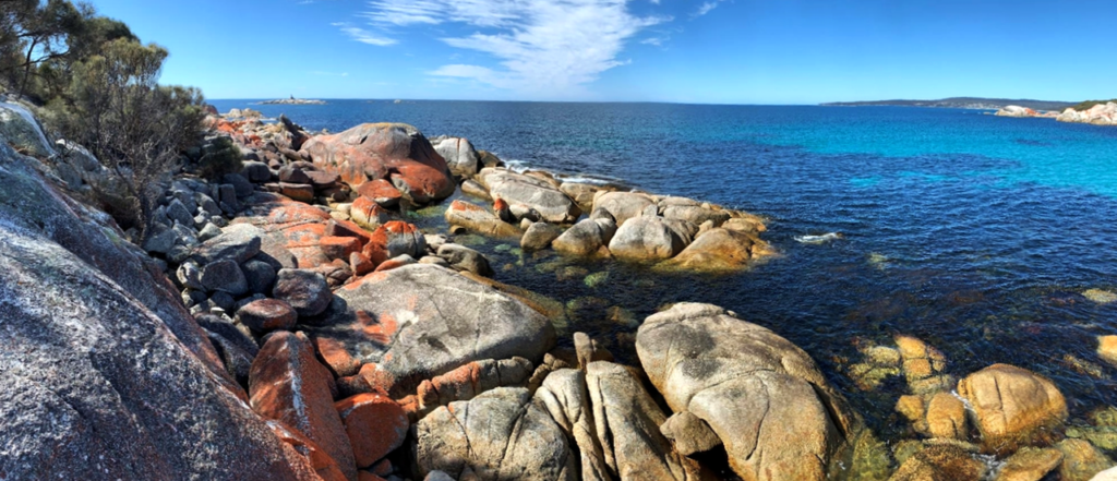
Here is an opportunity to explore the southern part of the Bay of Fires region, recognised internationally as one of Tasmania’s most beautiful places.
In preparation for the Taking on Goliath camp (to be held a couple of week after this walk), your leader, Nik, needs to make this day walk ahead of time to carry in reserves of fresh water for the Goliath campers. Does this mean that you have to carry extra water, which is heavy? No! You are welcome on this walk whether you carry extra water or not. NB - This is a day walk, NOT an overnight camping walk. The scenery will be just as beautiful either way, but if you want to build up your rugged outdoor fitness, carrying a few litres (1 litre = 1kg) of water for half the distance (you walk back without it) would be much appreciated. (bring a large back-pack with a strong harness - Nik will supply the water cask).
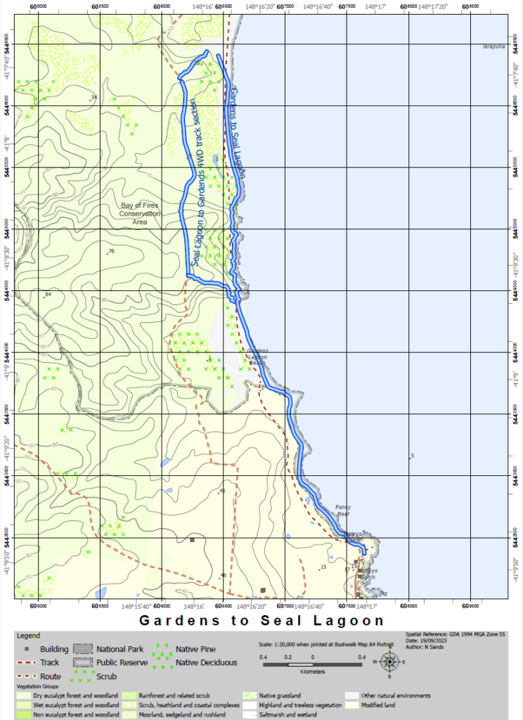
This walk along part of the Bay of Fires trail takes in beautiful beaches, wonderful granite outcrops and some lovely east-coast forest, including grass-trees (Grug!). The walking covers a wide variety of terrain, including beaches, solid rocks, small-wobbly-ankle-stretching rocks, dirt 4WD track and two short sections of untracked forest. There is one creek crossing (in both directions) that requires wet feet. No hills involved!
Total distance is 12 km return. Resilient older children would enjoy this walk. The distance requires a fairly steady walking pace to be kept up, so adequate fitness is needed, as well as suitable footwear. No hills, though!
Meeting Times and Places:
If you are interested in going on this walk, please phone your walk leader, Nik Sands Ph. 0429 387 777 to book in. The departure time is 7:30 am on Saturday 21st October. from the Door of Hope Church car park, Launceston. Other meeting places by arrangement with leader.
If you would like to arrange to meet the group at these places or elsewhere, please arrange with the leader, and please be at any meeting place 5 minutes ahead of the listed time. The leader should always be notified of any other people you intend to bring along, and you should always contact the walk leader if intending to participate in a Boots N' All walk.
To access this area from northern Tasmania: From Launceston, follow the Midland Highway 55km south to the junction of the Esk Main Road at Conara. Turn left and continue 69 km east through Fingal and Esk Main Road to St. Mary's, and then follow the Tasman Highway 38 km north to St. Helen's. At St. Helen's, take the Binnalong Bay road east, then north 8 km before turning left into Gardens Rd. Follow that road north for 13 km. The walk will begin from The Gardens parking area at the end of the public road. Drive time is about 2 hrs 20 min from Launceston.
Warnings:
Water! Per above, there is no drinking water in the area of the walk, so make sure you are carrying plenty for your own needs, apart from any you might be carrying for the campers.
Even on the delightful East Coast, the weather can be changeable, so please carry warm clothes and a raincoat, along with your lunch and snacks.
Be aware of possible hazards such as insect bites and snakes. Prepare for a variety of weather conditions from warm and sunny (hat, sunscreen etc) to cold, wet and windy. Sturdy sneakers or light walking boots are recommended. For bushwalking equipment and safety guidelines, Click Here.
Map details and references: Bay of Fires area: (most good touring maps will have the main roads) The area south of Eddystone-Larapuna is on map 8515 (George's Bay) in the 1:100000 series and on the Gardens (6044) and Binalong map (6043) in the 1:25000 maps.
No peakbagger points will be visited on this walk. For listing of peakbagger points, see the Hobart Walking Club Peakbagger’s Guide (2000 revision) which can be downloaded (Excel) from http://tastracks.webs.com/peakbaggers.htm The same web page contains several other listings of Tasmanian peaks.
GPX version of the track: Right-click here to download. Google Earth version of the track: Click here to open in Google Earth [if available on your device].
Click here to browse our entire collection of walk tracks, including to find GPX (.gpx) and Google Earth (.kml) versions of the track for this walk.
Click here to learn about using your phone as a navigation device, or to find out about handheld GPS devices.