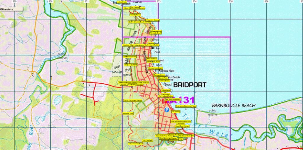
Join us for a relaxing seaside break at Bridport. The Brid River Track begins near the bridge at southern end of town, following the river west through bushland, and skirting through bushland up the western boundary of the town north to Adams Beach, continuing back via the beach track. Total distance is 11 km, but those having difficulty with the distance can do part of the walk, and the leader may choose a shortened loop depending on the fitness and enthusiasm of the party. Weather permitting, a swim may be a refreshing way of concluding the walk, along with a visit to a local coffee shop. The walk is relatively flat, although there is a steady rise to the highest point ("Mt. Arthur View" on the map - but hardly a mountain at not much more than 60 metres altitude!) before gradually losing height down to Adams Beach. The walk is suitable for younger children, especially if the option is taken to only do part of the walk.
Yes, you could pack your bathers and towel if the weather proves inviting enough for a swim!
Meeting Times and Places:
If you are interested in going on this walk, please phone the leader, Grace Hillman on 0490 840 866 to book in. The departure time is 8:30 am from the Door of Hope Church car park, Launceston. It will also be possible to meet Grace and the party at Bridport just north of the bridge at 9:30 am. If you would like to arrange to meet the group at these places or elsewhere, please arrange with the leader, and please be at any meeting place 5 minutes ahead of the listed time. The leader must be notified of any other people you intend to bring along.
To access this area from northern Tasmania: From Launceston, you can either follow the Tasman Highway from Newstead through Waverley and Scottsdale via the Sideling, or from Newnham via Lilydale Rd and choose one of several ways from Lilydale Rd. to Bridport, or follow the East Tamar Highway to Bell Bay and follow Bridport Road east to Bridport. It should take about an hour to arrive in Bridport, which is about 85 km from Launceston.
Warnings:
No particular warnings, but make sure you have clothing for both warm and cool weather including a hat and durable shoes. Well made sneakers should be fine. Please carry a drink - we suggest 750ml to 1 litre per person in case the day is warm.
For bushwalking equipment guidelines, Click here (although less of an issue on this walk!)
Map details:
Brid River Walking Track:
There is a website dedicated entirely to this track - Bridport Walking Track with extensive descriptions, and a map of the track - zoom in and click on the blue markers to get more information on each point.
The .gpx file linked below includes detailed waypoints of the points of interest on the track (likely copies from the site above), so if you have a GPS or a smartphone with mapping software, you should find it quite helpful.
No peakbagger points will be visited on this walk. For listing of peakbagger points, see the Hobart Walking Club Peakbagger’s Guide (2000 revision) which can be downloaded (Excel) from http://tastracks.webs.com/peakbaggers.htm The same web page contains several other listings of Tasmanian peaks.
GPX version of the track: Right-click here to download. Google Earth version of the track: Click here to open in Google Earth [if available on your device].
Click here to browse our entire collection of walk tracks, including to find GPX (.gpx) and Google Earth (.kml) versions of the track for this walk.
Click here to learn about using your phone as a navigation device, or to find out about handheld GPS devices.