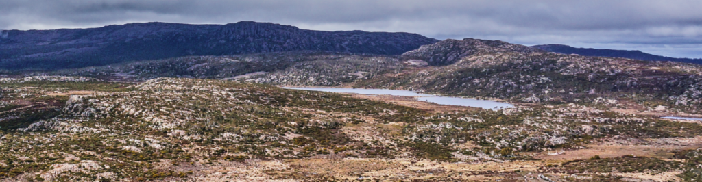
Our customary post-Christmas walk "to work off that Christmas cheer" takes us to the alpine escarpment of the Central Plateau via the Western Creek track. There should be a great showing of wildflowers of various kinds, and hopefully the scoparia will still be in full colour. We'll visit the rustic Whiteleys Hut near the imposing mass of Mt. Ironstone, and meander across country to Westons Lake.
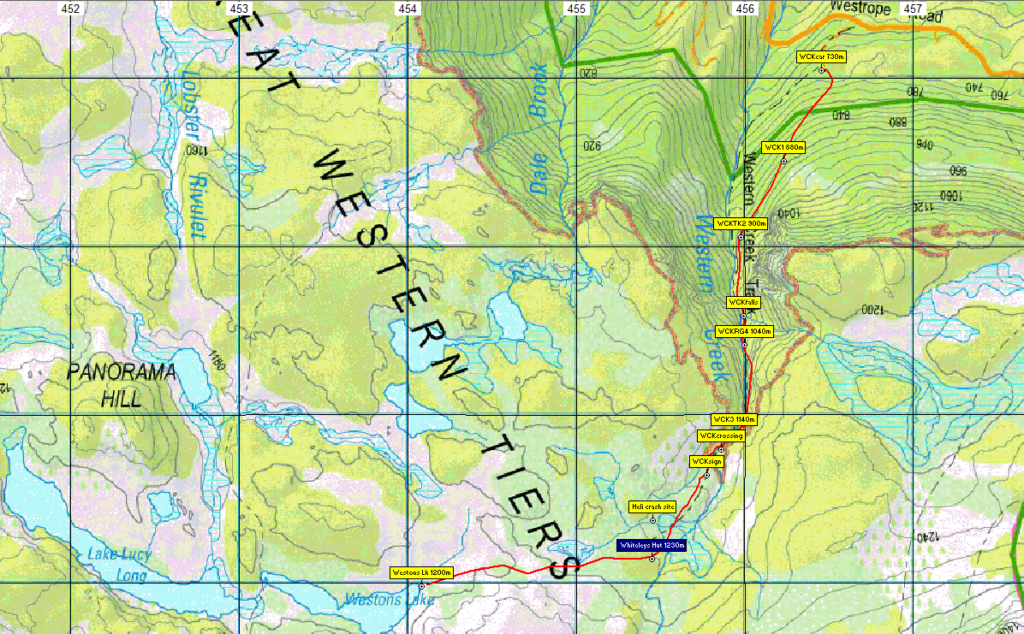
From Westrope Road near Western Creek, the walk follows the well-known Western Creek track from Dale Brook Road up the side of the Western Tiers, steadily climbing southward. A creek crossing at a pretty waterfall is a feature of this part. The track follows, then sidles, a ravine to reach the escarpment, less than 1 km from Whiteleys Hut. We then head west, cross-country for about 1.5 km to reach Westons Lake. Depending on time and the energy of the party, your leader may take a different route back to the edge of the escarpment before descending Western Creek track back to the cars. Total distance, including return trip, is about 10 km.
This walk is rated "medium" and is suitable for walkers, including energetic children, who have had some experience with steep and rocky tracks as well as off-track alpine walking. Even though it is summer, because of the exposed alpine conditions, walkers must be fully prepared for poor weather. Please see the warnings below.
Meeting Times and Places:
If you are interested in going on this walk, please contact your walk leader, Phil Dawson - email pidasms@gmail.com or ph. 6382 3561 after 6:30 pm to book in. The departure time is 8:30am from the Door of Hope Church car park, Launceston. Suggested meeting places if coming from elsewhere are at the Deloraine train park at 9:00 am or Dale Brook Rd. turnoff at 9:20 am.
If you would like to arrange to meet the group at these places or elsewhere, please arrange with the leader, and please be at any meeting place 5 minutes ahead of the listed time.
The leader should always be notified of any other people you intend to bring along, and you should always contact the walk leader if intending to participate in a particular Boots N' All walk.
To access this area from northern Tasmania: From Launceston, proceed along the Bass Highway to Deloraine (about 51 km). Follow the off-ramp into Deloraine and when crossing the bridge, turn right at roundabout to enter the “train park” car park. (If you were not meeting the group there, you would not turn off at the eastern exit into Deloraine. Instead, continue across Meander R. and uphill to the western exit, and to the roundabout at start of Mole Creek Rd.) After leaving the train park, follow the main street uphill through Deloraine to reach the large roundabout. Turn left into Mole Creek Rd. and go about 8 km before turning left into Dairy Plains Rd. Go all the way through Dairy Plains Rd. (several right hand turns and 2 junctions where you need to follow the signs). When you arrive at the T junction with Western Creek Rd, turn right and 800m further on, turn left up Westrope Rd. Go more or less straight for 4 km south, to reach the junction of Dale Brook Rd. which turns off to the right. The car park for the walk is about 500 metres from Westrope Rd. Westrope Rd. is all gravel, and somewhat degraded in parts, but should be accessible for 2WD vehicles with reasonable clearance.
Warnings:
The following codes [from our 2023 walks calendar] apply:
S Steep incline for at least part of the way
E Exposed alpine conditions ; can be dangerous in poor weather if not adequately equipped. For equipment and safety guidelines, Click Here.
Walkers are advised to wear strong shoes or boots. Gaiters are recommended. Even in summer, you should always carry wet weather gear as well as warm clothing including gloves and beanies in case of sudden weather changes. The destination of this walk is above 1000 metres altitude, and can be very exposed if the weather turns bad. Be prepared!
Map details:
Western Creek/Higgs Track area: 1:100000 map is Mersey (Tasmap 8114) and 1:25000 map for upper area is Lake Mackenzie (TasMap 3338).
Map reference:
Short ref. n/a
Zone Easting Northing Latitude Longitude
n/a
No peakbagger points will be visited on this trip. See The Peakbaggers Points List, which can be downloaded (Excel) from http://tastracks.webs.com/peakbaggers.htm which contains the 1983 and 2000 versions, developed from the original 1968 Hobart Walking Club version. A parallel and more recent but not identical list system is The Abels – also available on the same website, which also contains some other listings of Tasmanian peaks.
For GPX (.gpx) and Google Earth (.kml) versions of the track: Click here to browse our collection.
Direct links: GPX for this walk … KML for this walk
Right-click on the file and save target as to a location of your choice. (Suggest you click the Last modified at top to sort by date to get the most recent at top to find the file for the next walk).