Bastion Bluff 6th January 2024
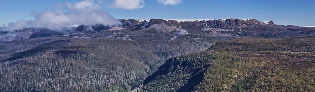
Our first walk for 2024, and actually starts close to start of the final walk of 2023. Bastion Bluff is the eastern prominence of the broad and high Ironstone plateau, which stretches from Mt. Ironstone at the head of Western Creek, to Meander Crag, soaring above Meander Falls. In good conditions, there are expansive views across the north as far as Bass Strait, and along the escarpment of the Western Tiers to the east. Apart from the steep climb from the car to the edge of the plateau, and the further steep ascent to the Ironstone plateau, it is not a particularly challenging walk, and would suit energetic and resilient children, and people with fitness suited to the steep terrain.
Walk Route
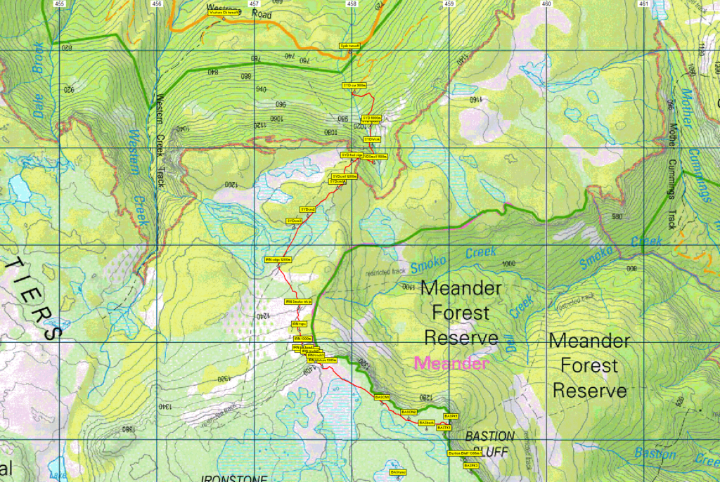
From Westrope Road near Western Creek, a steep and somewhat rough vehicular track will hopefully save us a further 500 metres walk and 100 metres altitude to reach the start of the walking track, alt. 900m. This climbs generally south before swinging west to reach the escarpment, about 1 km walking and gaining 250m alt. We then follow southwest over open alpine terrain, relatively level for the first km or so, then swing south for 500m, ascending gradually to meet a track that comes up from Smoko Creek. Continue further south, climbing at first gradually, then steeply for about 800m to attain the Ironstone plateau at 1400m altitude. A further 1.5km southeast over flat terrain brings us to the high point of Bastion Bluff. One of three high points in close proximity, of course, the peakbagger point is never the closest!
Apart from the steep climb from the car to the edge of the plateau, and the further steep ascent to the Ironstone plateau, it is not a particularly challenging walk, rated “medium+” and is suitable for walkers, including energetic children, who have had some experience with steep and rocky tracks as well as off-track alpine walking. Even though it is summer, because of the exposed alpine conditions, walkers must be fully prepared for poor weather. Please see the warnings below.
Meeting Times and Places:
If you are interested in going on this walk, please contact your walk leader, Basil Tkaczuk – phone or text 0438 664 402 to book in. The departure time is 8:00 am from the Door of Hope Church car park, Launceston. Suggested meeting places if coming from elsewhere are at the Deloraine train park at 8:30 am or Westrope Rd. turnoff at 8:50 am.
If you would like to arrange to meet the group at these places or elsewhere, please arrange with the leader, and please be at any meeting place 5 minutes ahead of the listed time.
The leader should always be notified of any other people you intend to bring along, and you should always contact the walk leader if intending to participate in a particular Boots N’ All walk.
To access this area from northern Tasmania: From Launceston, proceed along the Bass Highway to Deloraine (about 51 km). Follow the off-ramp into Deloraine and when crossing the bridge, turn right at roundabout to enter the “train park” car park. (If you were not meeting the group there, you would not turn off at the eastern exit into Deloraine. Instead, continue across Meander R. and uphill to the western exit, and to the roundabout at start of Mole Creek Rd.) After leaving the train park, follow the main street uphill through Deloraine to reach the large roundabout. Turn left into Mole Creek Rd. and go about 8 km before turning left into Dairy Plains Rd. Go all the way through Dairy Plains Rd. (several right hand turns and 2 junctions where you need to follow the signs). When you arrive at the T junction with Western Creek Rd, turn right and 800m further on, turn left up Westrope Rd. Westrope Rd. is all gravel, and somewhat degraded in parts, but should be accessible for 2WD vehicles with reasonable clearance. Go more or less straight for 5 km and follow past the tight bend across Western Creek, continuing east for about 2 km to reach the turnoff on right. The rough track should be driveable for SUVs with reasonable clearance, and zig-zags up the slope, saving nearly 700 metres walk.
Warnings:
The following codes [from our 2024 walks calendar] apply:
S Steep incline for at least part of the way
B Boulder field – walkers need to be able to confidently step from rock to rock.
L A long day’s walk – in excess of 3 hours each way. (we will hopefully be somewhat faster, though)
M Marshy or muddy sections – be prepared to walk with wet feet. (only if the weather is wet in preceding days)
E Exposed alpine conditions ; can be dangerous in poor weather if not adequately equipped.
For equipment and safety guidelines, Click Here.
Walkers are advised to wear strong shoes or boots. Gaiters are recommended. Even in summer, you should always carry wet weather gear as well as warm clothing including gloves and beanies in case of sudden weather changes. The destination of this walk is above 1000 metres altitude, and can be very exposed if the weather turns bad. Be prepared!
Map details:
Syds Track/Bastion Bluff area: 1:100000 map is Mersey (Tasmap 8114) and 1:25000 map for upper area is Lake Mackenzie (TasMap 4438).
Map reference:
Short ref. 587819
Zone Easting Northing Latitude Longitude
55G 4 59 160 53 81 795 -41.71459 146.50906
Bastion Bluff is worth 1 peakbagger point. See The Peakbaggers Points List, which can be downloaded (Excel) from http://tastracks.webs.com/peakbaggers.htm which contains the 1983 and 2000 versions, developed from the original 1968 Hobart Walking Club version. A parallel and more recent but not identical list system is The Abels – also available on the same website, which also contains some other listings of Tasmanian peaks.
For GPX (.gpx) and Google Earth (.kml) versions of the track: Click here to browse our collection.
Direct links: GPX for this walk … KML for this walk
Right-click on the file and save target as to a location of your choice. (Suggest you click the Last modified at top to sort by date to get the most recent at top to find the file for the next walk).