Mts Housetop and Riana Sat. 10th Feb. 2024
With a few unexpected changes in just the first month of the 2024 Boots N’ All calendar, we needed another walk after Frome Falls was moved from 10th Feb. and Darren has kindly investigated roads and agreed to lead a mini-peak-bagging day to these two peaks which are in his part of the state. Both are short walks, mainly through forest, but will give you a chance to further explore the region of farms, forestry and mountains south of Penguin.
Walk Routes:
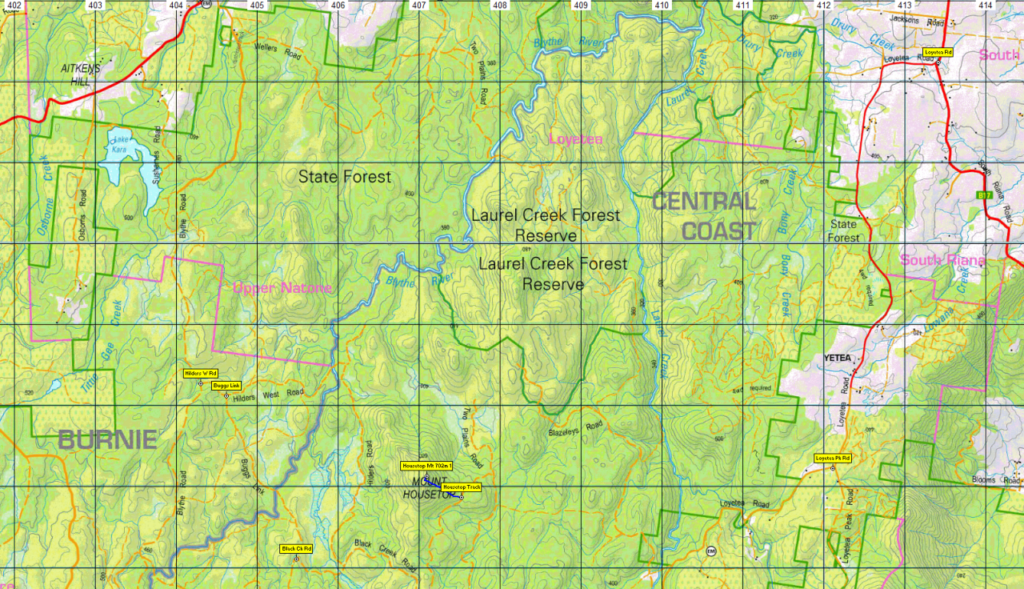
Mt. Housetop (alt. 702m) is only about 6 km west of Loyatea Pk which we visited with Darren last year. Following forestry roads that are 2WD accessible, we start at a waypoint (so we will need to use GPS) and expect to pick up a quite steep track, following west to gain 200m altitude over less than 800 metres! According to one report, the view from the top is well worth it – the southern high point offering a better view, especially towards the peaks further south, than the official summit.

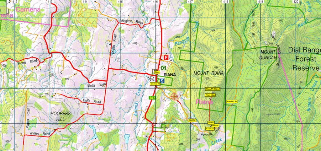
Mt. Riana (alt. 602m) is one of the southern peaks of the Dial Range, and sits parallel to a band of farming country that runs south from the coast at Sulphur Creek. From Ironcliffe Rd, (also the access for Mt. Duncan and other Dial peaks), the route heads northwest for 200 metres before following a ridge north for a little under a kilometre past rocky slabs to reach the summit. Some nice views to be had at various places along the summit ridge. Again, an altitude gain of about 200 metres.
Both walks suitable for energetic and sure-footed younger children, and moderately fit adults. Neither will be on well-formed tracks, and there may be fallen timber obstacles, so we’ve rated the walk easy-medium.
Meeting Times and Places:
If you are interested in going on this walk, please phone Darren Wunder on 0438 557 046 to book in. Meet 9 am at Hiscutt Park, Crescent Street Penguin by taking the right hand turn straight after the traffic lights if coming from Burnie or off the Bass Highway. A pond and windmill make it easy to spot. Please negotiate any alternative travel arrangements with the leader. You must contact the walk leader per details above if intending to join this walk. The leader should be notified of any other people you intend to bring along. Please be at any meeting place 5 minutes ahead of departure time.
Those coming from Launceston area should meet at Door of Hope southern carpark at 7:30 am. Check with Darren about who to meet there.
To access this area from Burnie: Follow the Bass Highway east from Burnie, turning off at Howth to follow the coastal road to reach the meeting place – 16 km. If coming from Devonport, its 22 km via the Bass Highway. Take the second exit off the highway, turn right at the traffic lights and the right turn straight after gets you to Hiscutt Park. An hour and a half from the middle of Launceston (130 km) is ample time to make it to Penguin.
To access the first walk from Penguin, head 17.5 km south via Pine Rd (B17) to South Riana. Turn left into South Riana Rd (still B17) and follow for 3 km before turning right into Loyetea Rd. Follow Loyetea Rd. south for 6 km to reach Loyetea Peak Rd, but continue along Loyatea Rd. for a further 2.8 km. Turn right into Blazeleys Rd and follow north for about 800m, then left and continue west just under 2 km, turn right and continue 300m, then left into Black Creek Rd. Follow SW for 600m and the start of the track is on the right. It is apparently unmarked, so waypoint navigation will be essential. Black Creek Rd. can also be reached via Blythe Rd which is off Upper Natone Rd, then Hilders West Road and Buggs Link to join Black Creek Rd. south of Mt. Housetop.
Leaving Mt. Housetop and returning to South Riana following the same route described above, continue north for 4.2 km to reach Cooke’s Rd, just south of Riana. Follow Cooke’s Rd. southeast for 1.5 km where there may still be a gate. Continue past the gate for another 800m, east then northeast, to reach the start of the route on left, in what is now Ironcliffe Rd. Should you wish to meet the party at any of those locations, please check with Darren when registering for the walks.
Equipment and Warnings:
Bring sturdy shoes, wet weather gear (even in summer, Tasmania’s weather can vary greatly), plenty of water, lunch and snacks. Optional: trekking poles, gaiters and camera
The following codes [from our 2024 walks calendar] apply:
S Steep incline for at least part of the way
The walk is on rough bush routes with potential fallen trees and other obstacles. There may be leeches, so apply insect repellent liberally, and wear gaiters if you have them. For equipment and safety guidelines, Click Here.
Map details:
Mt Housetop: 1:100000 map is Tasmap 8015 (Inglis) and 1:25000 map is 4042 (Loyetea)
Map references:
Short ref. 070269
Zone Easting Northing Latitude Longitude
55G 4 07 090 54 27 130 -41.30194 145.89019
Mt Riana: 1:100000 map is Tasmap 8115 (Forth) and 1:25000 map is 4043 (Riana)
Map references:
Short ref. 1175377
Zone Easting Northing Latitude Longitude
55G 4 17 640 54 37 880 -41.20626 146.01765
Mt. Housetop (alt. 702m) and Mt. Riana (alt. 602m) are worth 1 peakbagger point each. For o find out about these, see The Peakbaggers Points List, which can be downloaded (Excel) from http://tastracks.webs.com/peakbaggers.htm which contains the 1983 and 2000 versions, developed from the original 1968 Hobart Walking Club version. A parallel and more recent but not identical list system is The Abels – also available on the same website, which also contains some other listings of Tasmanian peaks.
For GPX (.gpx) and Google Earth (.kml) versions of the track: Click here to browse our collection.
Direct links: GPX for this walk : KML for this walk [note that gpx tracks for these peaks have been worked out approximately but should be fairly accurate].
Right-click on the file and save target as to a location of your choice. (Suggest you click the Last modified at top to sort by date to get the most recent at top to find the file for the next walk).