
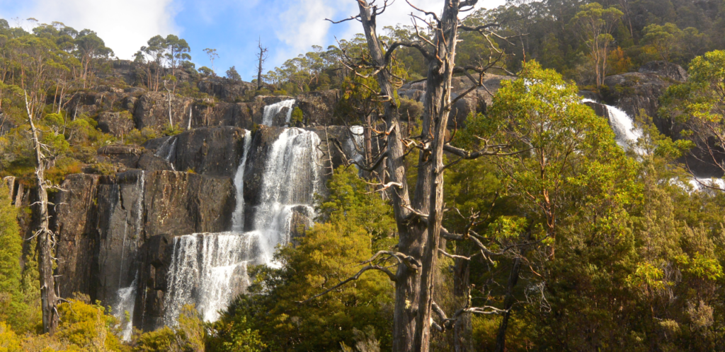
Grail falls Fagus Time Sat. 27th April 2024
By mid-autumn, the blaze of alpine summer colour from scoparia and other beautiful plants has long faded, but is replaced by another beauty as the endemic deciduous beech – “fagus” for short, takes on its glorious autumn colour – a magnet for wilderness photographers. What is Fagus? See https://parks.tas.gov.au/discovery-and-learning/plants/fagus for a great description. Some years, we make this pilgrimage to Cradle Mountain. This year, with the Mersey Forest Road reopened, Grail Falls is the destination.
Walk Route:
The walk begins at the very end of the Mersey Forest Road, south of Lake Rowallan (alt. 600m). A kilometre south, after crossing the Jackson Creek footbridge, the route heads southwest for about 1.5 km before rising steeply over the next kilometre or so, then plunging steeply to the shores of Chapter Lake. Impressive views of Grail Falls are seen on this descent. After skirting the southern end of the lake, another short climb reaches the top of the falls, with Chalice Lake (alt. 1100m) reached another 1 km southwest. Depending on weather conditions and the energy and fitness of the party, the walk might not proceed past the falls. With a total round trip of about 12 km, it will be necessary to keep up a reasonable pace due to the shortening days, so this walk has been rated medium-hard. Energetic, resilient and experienced older children should be able to manage the walk, but please consult with walk leader.
Meeting Times and Places:
If you are interested in going on this walk, please phone Phil Dawson on 0417 527 511 or email pidasms@gmail.com to book in by Thurs. evening. The departure time is 7:00 am from Door of Hope car park. Alternative meeting place: Deloraine 7:30 am. Check with leader for meeting spot. If you wish to meet with the group at any other place, please arrange with the leader. Please be at any meeting place 5 minutes ahead of departure time. However, you still need to contact the walk leader, if intending to walk. The leader should be notified of any other people you intend to bring along. Please be at any meeting place 5 minutes ahead of departure time.
To access this area from northern Tasmania: proceed along the Bass Highway to Deloraine (about 51 km), but do not turn off at the eastern exit into Deloraine. Instead, continue across Meander R. and up hill to the western exit, and to the roundabout at start of Mole Creek Rd. A further 24km will bring you to Mole Creek (sometimes used as a meeting place for our walks – check with leader). Continue west past Mole Creek, on what is now Liena Rd, making sure you turn south at the caravan park 4 km from the town. The road continues west until about 14 km from Mole Creek, it branches south, now called Mersey Forest Road. A little over 6 km south, you will pass turnoffs to Cradle Mountain and Devil’s Gullet (Lake Mackenzie) but keep going south, crossing the Mersey at Lake Parangana and passing the turnoffs for Bare Hill and Arm River. Another 17 km should see you cross below the Rowallan Dam. Continue south along the east side of Lake Rowallan, for about 16 km, by which time you are south of Lake Rowallan, until you reach the very end of the road and the beginning of the Moses Creek walking track.
Warnings:
The following codes [from our 2024 walks calendar] apply:
D Drive distance requires early departure
S Steep incline for at least part of the way
L A long days walk in excess of 3 hours each way
M Marshy or muddy sections be prepared to walk with wet feet.
E Exposed alpine conditions ; can be dangerous in poor weather if not adequately equipped
Click this link for a more detailed discussion of Preparation, Food and Safety guidelines for Boots N’ All walks.
Map details:
Grail Falls area: 1:100000 map is Mersey (Tasmap 8114) and 1:25000 map is Cathedral (Tasmap 4236)
Map references:
Short ref. n/a
Grail Falls:
Zone Easting Northing
55G 4 30 685 53 64 128
No peakbagger points will be visited on this walk. To find out about these, see The Peakbaggers Points List, which can be downloaded (Excel) from http://tastracks.webs.com/peakbaggers.htm which contains the 1983 and 2000 versions, developed from the original 1968 Hobart Walking Club version. A parallel and more recent but not identical list system is The Abels – also available on the same website, which also contains some other listings of Tasmanian peaks.
Click here to browse our entire collection of walk tracks, including to find GPX (.gpx) and Google Earth (.kml) versions of the track for this walk.
Direct links: GPX for this walk — KML for this walk
Click here to learn about using your phone as a navigation device, or to find out about handheld GPS devices.
