South Rattler Range – Sat. 13th April
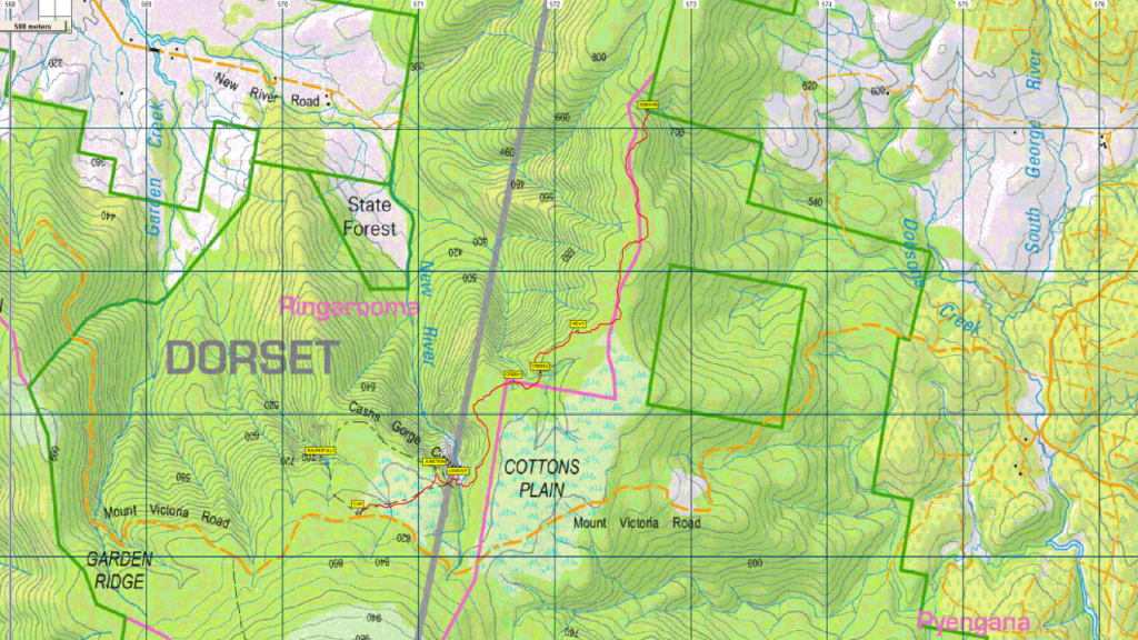
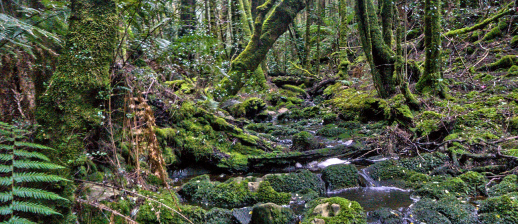
The Rattler Range runs from Cashs Gorge, near Ralphs Falls car park, north towards Rattler Hill near Mt Paris Dam road. It is one of many areas in Tasmania’s northeast that contains beautiful rain forest and creeks. This walk traverses the southern half of the range as far as Dobsons Creek. We will begin by parking at the Ralphs Falls car park and then walk along the formed track to the lookout overlooking Cashs Gorge. From there we will follow a taped route off track down into a shallow gully and then up onto the Rattler Range plateau. From there we will walk through beautiful rainforest, crossing a couple of creeks on the way. There will be a couple of spots en route where we can obtain views northwest down the valley towards Ringarooma if the weather is clear. After about 3 hours of walking we will descend quite steeply about 50m to Dobsons Creek, a beautiful spot, where we will stop for lunch. After that we will retrace our steps back to the cars.
The walk is about 11 km return with less than 200m elevation gain spread throughout the day and will take us at least 6 hours to complete. The walk follows a taped route all the way, but this is mostly not on a formed track and could be hard to follow in places. It requires stepping over logs and rocks and includes a couple of steeper slippery sections where care is required with footing, and which might require holding on to vegetation or rocks for stability. There are also at least two or three potentially slippery creek crossings, although these should not present too much of a problem to most walkers. Therefore it is rated medium, and will be suitable for reasonably fit adults and energetic children.
Meeting Times and Places
If you are interested in going on this walk, please phone the walk leader, Phil Andrew, on 0408 014 757 or email pandrew.tas@gmail.com, to register. The departure time is 7:30 am from Door of Hope car park. If you wish to meet with the group at any other place, please arrange with the leader. However, you still need to contact the walk leader, if intending to walk. The leader should be notified of any other people you intend to bring along. Please be at any meeting place 5 minutes ahead of departure time.
To access this area from northern Tasmania:
There is more than one way to get to Ringarooma, but perhaps the most comfortable is to proceed from Launceston via Northern Outlet, turning off at University Connector to head for Lilydale Rd. Follow through Lilydale and continue through Lebrina, Golconda, Nabowla and Lietinna to Scottsdale (70 km from Launceston via this route).
Alternatively, the Tasman Highway can be followed through Waverley, crossing the Sideling to reach Scottsdale. Please advise the leader if travelling independently.
Leaving Scottsdale, follow the Tasman Highway SE through Tonganah and over the Billycock Hill to the Ledgerwood junction, just over 20 km from Scottsdale. Turn right and follow a further 8 km through Ledgerwood to Ringarooma. (Mostly gravel roads from here on but ok for cars and 2WD vehicles) Follow New River Rd. SE from Ringarooma, keeping on that road for 5.8 km to reach Mt. Victoria Rd. Turn right, and follow for 10 km to reach the Ralphs Falls car park, just north of the prominent Mt. Victoria.
Warnings:
The following codes apply from our 2024 walks calendar:
D – – Drive distance requires early departure
M – – Marshy or muddy sections – be prepared to walk with wet feet
S – – Steep incline for at least part of the way
Bushwalking can be dangerous in poor weather if not adequately equipped; For equipment and safety guidelines, Click Here.
Map details:
South Rattler Range: 1:100000 map is Forester (Tasmap 8415) and 1:25000 maps are is Blue Tier (Tasmap 5843) and Victoria (Tasmap 5642)
Short ref. n/a
Zone Easting Northing Latitude Longitude
n/a
No peakbagger points will be visited on this trip. To find out about these, see The Peakbaggers Points List, which can be downloaded (Excel) from http://tastracks.webs.com/peakbaggers.htm which contains the 1983 and 2000 versions, developed from the original 1968 Hobart Walking Club version. A parallel and more recent but not identical list system is The Abels – also available on the same website, which also contains some other listings of Tasmanian peaks.
For GPX (.gpx) and Google Earth (.kml) versions of the track: Click here to browse our collection.
Direct links: GPX for this walk : KML for this walk.
Right-click on the file and save target as to a location of your choice. (Suggest you click the Last modified at top to sort by date to get the most recent at top to find the file for the next walk).