Point Vision – Sat. 25th May 2024
Note: This walk replaces the planned walk to Lake Lucy Long, again cancelled due to the plateau being closed for deer culling for the entire month of May.
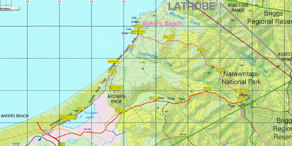
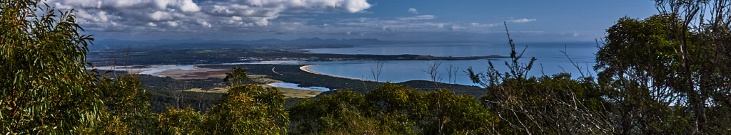
While it’s only 2 years since Boots N’ All visited Point Vision, a prominent hill in the Narawntapu National Park, our approach this time will be from Bakers Beach, instead of old roads from the south. The walk includes a mix of coastal heathlands, open forest, some craggy shoreline, beach walking and the shore of Springlawn Lagoon. Expansive views to the northwest from the high point of Point Vision, with further good views as the walk continues northwest. Total distance is just under 17km, depending on whether side trips are made in the Little Badger Head area.
Walk route:
The walk starts near the ranger station carpark, and heads east on a fire trail to the south of Springlawn Lagoon, largely flat for the best part of 5 km, then continuing east and rising steadily over the next 2 km before turning briefly north for the final ascent to Point Vision, alt. 386m. A ridge is followed northwest for a couple of km, losing altitude fairly steeply at first, then more gradually, before swinging in a more westerly direction to reach the coast near Little Badger Head. Descending to the beach, the shore is followed for about 1.5 km before turning inland but remaining relatively flat, to follow the Archers Knob track back along the northern shore of Springlawn Lagoon and the carpark. While the walking is quite easy, the distances suggest a reasonable level of fitness is needed to keep up a good walking pace. Energetic and resilient children should be able to manage the walk.
Meeting Times and Places:
If you are interested in joining this walk, please phone or text John Tabor on 0475 566 389 to book in. The departure time is 7:30 am from Door of Hope carpark in South Launceston. Allow 1 hour to Bakers Beach if driving from the Launceston area. If you would like to arrange to meet elsewhere, please arrange with the leader, and please be at any meeting place 5 minutes ahead of the listed time. The leader must be notified of any other people you intend to bring along.
To access this area from northern Tasmania:
From Launceston, follow the West Tamar Highway (A7) 24 km to Exeter, and turn left into the Frankford Highway B71, following it for 41 km through Frankford to reach the junction of Bakers Beach Rd C740 on the right, just short of the Franklin Rivulet (South East Arm) bridge. Head north a little over 13 km to reach the ranger station and carpark from where the walk starts. (It is also possible to follow the Bass Highway from Launceston, past Deloraine, then at Sassafras, head north via Chapel Rd C713 to reach Harford, then head east per below.)
If coming from the northwest, it’s about 26 km to the start of Bakers Beach Rd, travelling via Bass Highway for just over 5 km (but only about 3 km east of the Mersey bridge), then just north along Port Sorell Rd (about 400 metres), turn right into Frankford Rd, aka Frankford Hwy), continuing east through Moriarty and Thirlstan, then south, turning east again just short of Harford, past the 2 Port Sorell bridges to reach Bakers Beach Rd.
Warnings:
L A long day’s walk – close to 3 hours each way.
You should carry wet weather gear as well as warm clothing in case of sudden weather changes. Walkers should carry water with them – we suggest at least 1 litre. Also bring your lunch and snacks. For equipment and safety guidelines, Click Here.
Map details:
Bakers Beach and Badger Head: 1:100000 map is Tamar (TasMap 8215) and 1:25000 map for upper area is Port Sorell (TasMap 4644).
Map reference: Badger Head
Short ref. n/a
Zone Easting Northing Latitude Longitude
55G 4 70 507 54 50 558 -41.57426 146.38929
No peakbagger points will be visited on this trip. To find out about these, see The Peakbaggers Points List, which can be downloaded (Excel) from http://tastracks.webs.com/peakbaggers.htm which contains the 1983 and 2000 versions, developed from the original 1968 Hobart Walking Club version. A parallel and more recent but not identical list system is The Abels – also available on the same website, which also contains some other listings of Tasmanian peaks.
For GPX (.gpx) and Google Earth (.kml) versions of the track: Click here to browse our collection.
Direct links: GPX for this walk : KML for this walk.
Right-click on the file and save target as to a location of your choice. (Suggest you click the Last modified at top to sort by date to get the most recent at top to find the file for the next walk).