
Mt. Beecroft – Sat. 11th May 2024
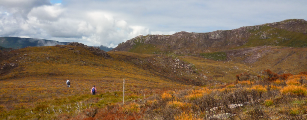
Hopefully before the winter snows set in, we have a late autumn walk to Mt. Beecroft, a few km west of the Pencil Pine area at Cradle Mt, and above the Vale of Belvoir and Vale River – a beautiful open alpine area south of the highest point of the Cradle Link Road. At this time of the year, there will likely be frost, with fog in the valleys, but hopefully a clear day up high to entice intrepid walkers and their cameras!
This walk is rated “medium” and is suitable for walkers, including older children, who have had some experience with basic alpine tracks, steep in a few places and somewhat uneven underfoot. Walkers need to be able to keep going for sustained distances (approx. 10 km for the round trip). Total gain of altitude is only about 200 metres from start to summit. Because of the exposed alpine conditions, walkers must be fully prepared for poor weather. Please see the warnings below.
Meeting Times and Places:
If you are interested in going on this walk, please phone your walk leader, Grace Hillman, ph. 0490 840 866 to book in. The departure time is 7:00 am from the Door of Hope Church car park, Launceston. Suggested meeting places if coming from elsewhere could be Sheffield at Claude Rd. turnoff at 7:50 am or Moina at 8:20 am. Other meeting places by arrangement with leader. If you would like to arrange to meet the group at these places or elsewhere, please arrange with the leader, and please be at any meeting place 5 minutes ahead of the listed time.
The leader should always be notified of any other people you intend to bring along, and you should always contact the walk leader if intending to participate in a particular Boots N’ All walk.
To access this area from northern Tasmania: Roads to Cradle Mt. are well signposted, and the area can be accessed from several directions. From Sheffield, go south along Claude Rd (C136) through Gowrie Park and westward down into the Forth Valley (now Cethana Rd but still C136)), continuing up the other side to Moina. Turn south into Cradle Mt. Rd C123 After approx. 20 km, you will reach the Cradle Mt. turnoff. To reach the start of the walk, continue along what is now Belvoir Rd. (C132) for 9 km to reach the Belvoir lookout, which has a car park on the right, and power transmission lines crossing the road about 100m further on. The walk starts on the opposite side of the road. Allow about 2 hours driving time from Launceston, and less, of course, if coming from NW area.
Warnings:
The following codes [from our 2024 walks calendar] apply:
D Drive distance requires early departure
S Steep incline for at least part of the way
M Marshy or muddy sections – be prepared to walk with wet feet.
E Exposed alpine conditions – can be dangerous in poor weather if not fully equipped… see below.
This walk is 1000 metres altitude or higher for most of the distance and can be very exposed if the weather is bad. Be prepared! Walkers should wear sturdy footwear due to uneven surfaces. Gaiters can give a measure of extra support and protection against adverse conditions. You should always carry wet weather gear as well as warm clothing in case of sudden weather changes.
Click this link for a more detailed discussion of Preparation, Food and Safety guidelines for Boots N’ All walks.
Map details:
Mt. Beecroft (alt. 1136m): 1:100000 map is Sophia and 1:25000 map is Pencil Pine
Map references:
Short ref. 030969
Zone Easting Northing Latitude Longitude
55G 4 03 190 53 97 110 -41.57183 145.83881
Mt. Beecroft is worth 2 peakbagger points. To find out about these, see The Peakbaggers Points List, which can be downloaded (Excel) from http://tastracks.webs.com/peakbaggers.htm which contains the 1983 and 2000 versions, developed from the original 1968 Hobart Walking Club version. A parallel and more recent but not identical list system is The Abels – also available on the same website, which also contains some other listings of Tasmanian peaks.
GPX version of the track: Right-click here to download. Google Earth version of the track: Click here to open in Google Earth [if available on your device].
Click here to browse our entire collection of walk tracks, including to find GPX (.gpx) and Google Earth (.kml) versions of the track for this walk.
Click here to learn about using your phone as a navigation device, or to find out about handheld GPS devices.
