
Cathedral Mountain and Chalice Lake (camping) 13-14 Jan. 2024
NOTE; This walk was cancelled due to an injury to the leader. It was replaced by a day walk to Frome Falls.
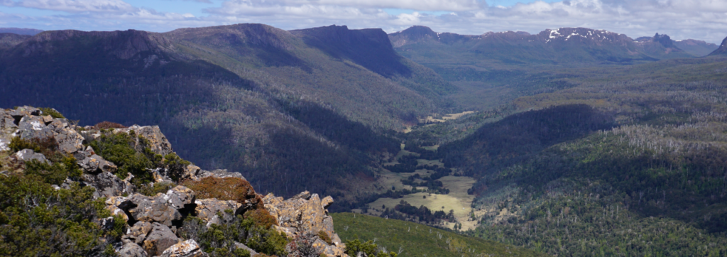
It’s some years since we had a Boots N’ All camping trip to Cathedral Mountain and Chalice Lake, and on that occasion, it snowed. Much less likelihood of that in mid-January, and hopefully, there will be glorious summer weather in which to explore the beauty of Grail Falls, Chalice Lake and at least some of the clerically themed peaks of the Cathedral plateau, four of which carry peakbagger points.
Walk Route:
The walk begins at the very end of the Mersey Forest Road, south of Lake Rowallan (alt. 600m). A kilometre south, after crossing the Jackson Creek footbridge, the route heads southwest for about 1.5 km before rising steeply over the next kilometre or so, then plunging steeply to the shores of Chapter Lake. Impressive views of Grail Falls are seen on this descent. After skirting the southern end of the lake, another short climb reaches the top of the falls, with Chalice Lake (alt. 1100m) reached another 1 km southwest. Your leader will choose a base camp site in the vicinity of the lake, and there will be the opportunity on day 2 to explore the western peaks, including Cathedral Mountain, less than 3 km away, and 300-400m higher.
You must be fully self-sufficient for this walk, including tent, sleeping gear, rain gear, stove and food. A checklist of essentials is a good idea. Parks and Wildlife Tasmania have a comprehensive Safety in Parks page which covers many aspects of bushwalking safety and equipment, including a Walker Pack List that is well worth a read. However, much of this gear can be shared with a partner – perhaps a more experienced walker who already has some of the big-ticket items such as tent and stove. This area is known to have four seasons in one day, including blizzards in summer, so walkers must be prepared for anything, despite what the forecast may say.
Note also that a valid Parks Pass is needed for each vehicle, or you may have registered as an individual.
This walk has been rated medium, but will require enough fitness to carry the heavier overnight camping equipment and food up some quite steep sections of track. Energetic, resilient and experienced older children should be able to manage the walk, but please consult with walk leader.
Meeting Times and Places:
If you are interested in going on this walk, please phone Nik Sands on 0429 387 777 by Wednesday night, 10th January, so that cars, tent sharing etc can be arranged. The departure time is 7:00 am from Door of Hope car park. Alternative meeting place: Deloraine 7:30 am. Check with leader for meeting spot. If you wish to meet with the group at any other place, please arrange with the leader. Please be at any meeting place 5 minutes ahead of departure time. However, you still need to contact the walk leader, if intending to walk. The leader should be notified of any other people you intend to bring along. Please be at any meeting place 5 minutes ahead of departure time.
To access this area from northern Tasmania: proceed along the Bass Highway to Deloraine (about 51 km), but do not turn off at the eastern exit into Deloraine. Instead, continue across Meander R. and up hill to the western exit, and to the roundabout at start of Mole Creek Rd. A further 24km will bring you to Mole Creek (sometimes used as a meeting place for our walks – check with leader). Continue west past Mole Creek, on what is now Liena Rd, making sure you turn south at the caravan park 4 km from the town. The road continues west until about 14 km from Mole Creek, it branches south, now called Mersey Forest Road. A little over 6 km south, you will pass turnoffs to Cradle Mountain and Devil’s Gullet (Lake Mackenzie) but keep going south, crossing the Mersey at Lake Parangana and passing the turnoffs for Bare Hill and Arm River. Another 17 km should see you cross below the Rowallan Dam. Continue south along the east side of Lake Rowallan, for about 16 km, by which time you are south of Lake Rowallan, until you reach the very end of the road and the beginning of the Moses Creek walking track.
Warnings:
The following codes [from our 2024 walks calendar] apply:
D Drive distance requires early departure
S Steep incline for at least part of the way
L A long days walk in excess of 3 hours each way
M Marshy or muddy sections be prepared to walk with wet feet.
E Exposed alpine conditions ; can be dangerous in poor weather if not adequately equipped
Click this link for a more detailed discussion of Preparation, Food and Safety guidelines for Boots N’ All walks.
Map details:
Grail Falls area: 1:100000 map is Mersey (Tasmap 8114) and 1:25000 map is Cathedral (Tasmap 4236)
Map references (no guarantee that all these places will be visited, though):
Cathedral Mt. (1pt):
Short ref. 261622
Zone Easting Northing Latitude Longitude
55G — 4 26 190— 53 62 320 -41.88761 146.11033
Twin Spires (2 pts):
Short ref. 267629
Zone Easting Northing Latitude Longitude
55G — 4 26 810 — 53 63 090 -41.88073 146.11790
Bishop Peak (1 pt):
Short ref. 275643
Zone Easting Northing Latitude Longitude
55G — 4 27 640 — 53 64 410 -41.86892 146.12806
Dean Bluff (1 pt):
Short ref. 281664
Zone Easting Northing Latitude Longitude
55G — 4 28 210 — 53 66 500 -41.85015 146.13519
See list above for peakbagger points. See The Peakbaggers Points List, which can be downloaded (Excel) from http://tastracks.webs.com/peakbaggers.htm which contains the 1983 and 2000 versions, developed from the original 1968 Hobart Walking Club version. A parallel and more recent but not identical list system is The Abels – also available on the same website, which also contains some other listings of Tasmanian peaks.
For GPX (.gpx) and Google Earth (.kml) versions of the track: Click here to browse our collection.
Direct links: GPX for this walk … KML for this walk
Right-click on the file and save target as to a location of your choice. (Suggest you click the Last modified at top to sort by date to get the most recent at top to find the file for the next walk).
