Walled Mountain (camping) 9-11 March 2024
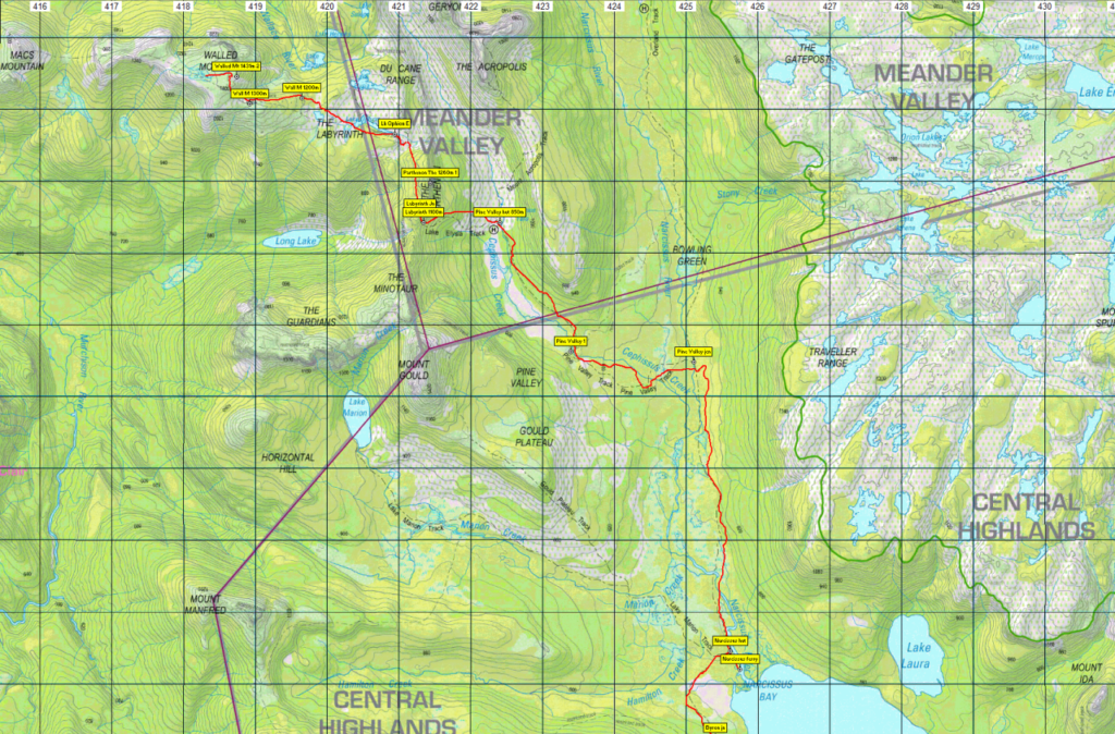
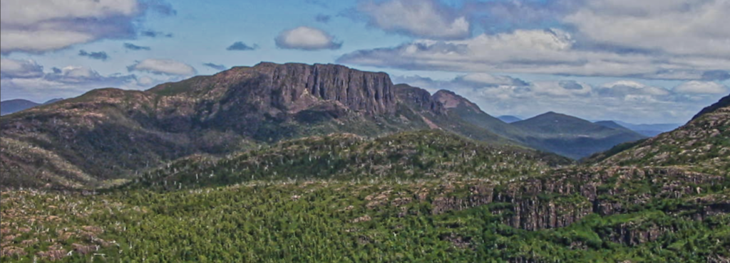
This two night walk will take us into the Tasmanian Wilderness World Heritage Area and offer us incredible views across multiple mountain ranges. We’ll walk through rainforests, along lakes and tarns, up and down hills, all leading through the Labyrinth and to the summit of Walled Mountain (alt. 1431m).
Saturday 9th March (approx. 9.5km, 2-3 hours):
After driving from Launceston, the adventure for the day will start with a nice 30 minute ride on the ferry up the length of Lake St Clair, which will give us our first glimpse of the Du Cane Range. Once we arrive at Narcissus, we will walk to our campsite at Pine Valley. This will be mostly through rainforest and is fairly flat; but there’s plenty of myrtle tree roots to watch out for. The hut at Pine Valley can sleep up to 16 people, with 4 tent platforms and open ground to camp, there’s a toilet and tank water available.
Sunday 10th March (approx. 13km, 8 hours return):
We will only need to carry a daypack for today, which will make the 600m of elevation gain easier to manage. The walk will start off by heading into the Labyrinth, and just as your legs start to warm up, we will be going straight up 300m elevation. We will then skirt along the edge of the Parthenon and start to see 360° views both back to Lake St Clair as well as across the Du Cane Range and into the Labyrinth. After a short drop down, we will be walking along lakes and heading west towards Walled Mountain. It’s not a technical climb and apart from one short pinch, is a relatively gradual incline. The views from here cannot be described, so you’ll just have to come and see for yourself. We’ll walk the same route back to Pine Valley for the night.
Monday 11th March (approx. 27.5km, 7-8 hours):
We will cover a significant distance today, but there are no hills or any technical sections. We’ll pack up camp nice and early and start the walk back to Narcissus. We will then follow the track along the western edge of Lake St Clair. This track starts in myrtle rainforest before transitioning into eucalypt forest. We’ll have lunch at Echo Point hut, which is almost half way along the lake, and has beautiful views looking straight across the lake to Mt Ida. The track meanders through the forest before arriving back at Cynthia Bay (complete with burgers and drinks if so desired).
If you would like to come on this walk, please note that you must book your own ferry trip. The cost is $55 per adult. Please contact Lake St Clair Lodge and book the 12:30 ferry departing from Cynthia Bay to Narcissus on the 9th March. If this is full, then book the 15:00 ferry and we will make it work. As it’s a long weekend, it’s advised to make this booking as soon as possible.
Contact details to book: sceniccruises@lakestclairlodge.com.au or Ph. 03 6289 1137.
You must be fully self-sufficient for this walk, including tent, sleeping gear, rain gear, stove and food. A checklist of essentials is a good idea. Parks and Wildlife Tasmania have a comprehensive Safety in Parks page which covers many aspects of bushwalking safety and equipment, including a Walker Pack List that is well worth a read. However, much of this gear can be shared with a partner – perhaps a more experienced walker who already has some of the big-ticket items such as tent and stove. This area is known to have four seasons in one day, including blizzards in summer, so walkers must be prepared for anything, despite what the forecast may say.
Note also that a valid Parks Pass is needed for each vehicle, or you may have registered as an individual.
This walk would rate as medium-hard due to the distances and the need to carry a heavy pack for the longer exit. Please discuss your level of experience with the leader.
Booking Details, Meeting Times and Places:
If you are interested in going on this walk, please phone Hannah Waterhouse on 0427 026 233 to book in, preferably by Thursday night, 29th February, so that cars, ferry, tent sharing etc can be arranged. Also…
New! Online Registration required! 2024 SU safety regulations require completion of an online registration form for all overnight camping trips. You must still contact Hannah, however, to confirm that this is the right walk for you.
Register at: Boots N’ All Walled Mountain Camping Trip – March 2024 – SU Australia
The departure time is 8:30 am from Door of Hope carpark in South Launceston. Additional meeting points can be arranged if needed. However, you still need to contact the walk leader per details above if intending to walk. The leader should be notified of any other people you intend to bring along. Please be at any meeting place 10 minutes ahead of departure time.
To access this area from northern Tasmania:
From Launceston, head towards Deloraine on the Bass Highway (50 km) and take the first (eastern) turn from the highway into Deloraine. Continue into the town and turn left immediately before the bridge (unless the group is using the train park across the bridge as a meeting place – see above). From Deloraine, head south along the “Lake Highway” – now Highland Lakes Rd. (but the first bit may be called Meander Rd!). Make sure to turn left after 7 km at signposted junction for Highland Lakes Rd. Continue south through Golden Valley, up past Quamby Bluff and Projection Bluff, and south along the western side of Great Lake. 52 km from the junction and 59 km from Deloraine, you pass through Liawenee, and continue another 9 km south to junction of Marlborough Rd. Turn right and follow through this gravel road, past Bronte Park to the Lyell Highway (about 30 km). Turn right, and head another 25 km west to reach Derwent Bridge. The road to Lake St Clair is on the right, just past the bridge. Follow the road for 5 km to reach Cynthia Bay, with its car parks and visitor centre, where the boat trip begins.
Warnings:
The following codes [from our 2024 walks calendar] apply:
E Exposed alpine conditions – can be dangerous in poor weather if not fully equipped – see below.
S Steep incline for at least part of the way
L A long day’s walk – in excess of 3 hours each way.
The 2nd day of walking takes you to over 1400 metres altitude, and can be very exposed if the weather is bad, even at this time of year. Be prepared! Walkers should wear sturdy footwear due to uneven surfaces, and gaiters for mud, rough vegetation and snakes. You should always carry wet weather gear as well as warm clothing in case of sudden weather changes. For equipment guidelines, CLICK HERE.
Map details:
Walled Mountain: 1:100000 map is Mersey (8114) and 1:25000 map is DuCane (4035).
Map reference: 186562
Zone Easting Northing Latitude Longitude
55G 4 19 750 53 64 125 -41.87072 146.03296
The Parthenon: 1:100000 map is Mersey (8114) and 1:25000 map is Dome (4235).
Map reference: 212548
Zone Easting Northing Latitude Longitude
Walled Mountain is worth 2 peakbagger points. The Parthenon, which is a 10 minutes to one side of the track along the Labyrinth, is worth 1 peakbagger point. To find out about these, see The Peakbaggers Points List, which can be downloaded (Excel) from http://tastracks.webs.com/peakbaggers.htm which contains the 1983 and 2000 versions, developed from the original 1968 Hobart Walking Club version. A parallel and more recent but not identical list system is The Abels – also available on the same website, which also contains some other listings of Tasmanian peaks.
For GPX (.gpx) and Google Earth (.kml) versions of the track: Click here to browse our collection.
Direct links: GPX for this walk … KML for this walk
Right-click on the file and save target as to a location of your choice. (Suggest you click the Last modified at top to sort by date to get the most recent at top to find the file for the next walk).