Cathcart Bluff – Sat. 24th February 2024
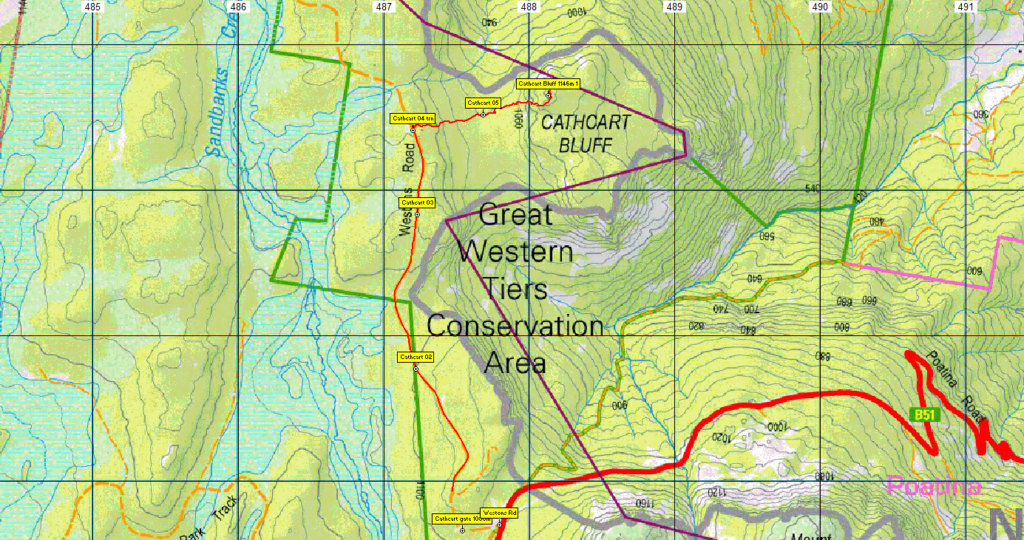
This peak is not often visited but is easily accessed from the Poatina Road and in good weather provides some nice views of the Western Tiers. We will park at the boom gate on Westons Road, about 500m from its junction with the Poatina Road. We will walk north along Westons Road for about 45 mins over a distance of about 3 km. Starting at an altitude of 1120 m, we will slowly descend about 40 m before regaining it. At that point we will leave the road and head down through the bush following a taped route and dropping about 70 m to the saddle where we will take a break in the cool forest. We will then head steeply uphill again, mostly over small rocks following cairns, gaining about 100m. We will stop at one point en route to take in the views and then press on to the summit of Cathcart Bluff which is at 1146m. This will take about 1½ hours from when we leave the road. We will have lunch on top if the weather is reasonable and then retrace our steps to the car.
The walk is about 9 km in total. Just under 6 km will be easy road walking, the rest will be off track through forest or over rocks and will at times include climbing over logs and rocks and some steeper slippery sections where care is required with footing. The walk is rated medium, and will be suitable to reasonably fit adults and energetic children.

Booking Details, Meeting Times and Places
If you are interested in going on this walk, please phone the walk leader, Phil Andrew, on 0408 014 757 or email pandrew.tas@gmail.com, to register. The departure time is 8:30 am from Door of Hope car park in Launceston. If you wish to meet with the group at any other place, please arrange with the leader. However, you still need to contact the walk leader, if intending to walk. The leader should be notified of any other people you intend to bring along. Please be at any meeting place 5 minutes ahead of departure time.
To access this area from northern Tasmania:
From Launceston, head south on the Midland Highway for 18 km, keeping an eye out for the B52 exit on left as you begin to pass Perth. Follow B52 for 4.5km to the Longford roundabout, continuing into Longford, then through Longford, swinging right to Cressy Rd. B51. Continue for 11 km to Cressy, and through Cressy, continue south another 7.5km and turn right into Poatina Rd. Follow Poatina Rd. for 29 km, past the Palmerston switchyard, past the Poatina turnoff, and up the switchbacks to reach the top of the Great Western Tiers. The Westons Rd junction is on the right. Follow Westons Rd for about 500m to reach the boom gate where the walk will start.
Warnings:
The following codes apply from our 2024 walks calendar:
B Boulder field – walkers need to be able to confidently step from rock to rock.
C Climbing sections using rocks and vegetation as hand holds.
E Exposed alpine conditions – can be dangerous in poor weather if not fully equipped – see below.
S Steep incline for at least part of the way
There will be very little drinkable water on this walk so you will need to carry your own – 1.5-2 litres per person is recommended. Walkers are advised to wear strong shoes or boots. Gaiters are recommended due to scrubby patches. Even in summer, you should always carry wet weather gear as well as warm clothing including gloves and beanies in case of sudden weather changes. The destination of this walk is above 1000 metres altitude, and can be very exposed if the weather turns bad. Be prepared! For equipment and safety guidelines, Click Here.
Map details:
Cathcart Bluff: 1:100000 map is Tasmap 8214 (Meander) and 1:25000 map is 4317 (Poatina)
Map references:
Short ref. 880735
Zone Easting Northing Latitude Longitude
55G ~~ 4 88 130 ~~ 53 73 650 ~ -41.78892 ~~ 146.85714
Cathcart Bluff is worth 1 peakbagger point. To find out about these, see The Peakbaggers Points List, which can be downloaded (Excel) from http://tastracks.webs.com/peakbaggers.htm which contains the 1983 and 2000 versions, developed from the original 1968 Hobart Walking Club version. A parallel and more recent but not identical list system is The Abels – also available on the same website, which also contains some other listings of Tasmanian peaks.
For GPX (.gpx) and Google Earth (.kml) versions of the track: Click here to browse our collection.
Direct links: GPX for this walk : KML for this walk.
Right-click on the file and save target as to a location of your choice. (Suggest you click the Last modified at top to sort by date to get the most recent at top to find the file for the next walk).