McDowalls Hill – Sat. 27th January 2024
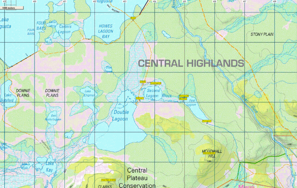
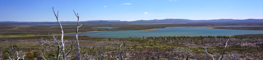
While we had listed Jilletts Tier as the walk for the end of January, it has proved difficult to find out whether access is permitted, both around the shores of Lagoon of Islands – a former Hydro dam that was demolished from 2012 to restore the unique “floating islands” of the lagoon, and over the land on which Jilletts Tier stands. Instead, your leader will take you on a ramble past the fishing mecca of Second and First Lagoons south of Lake Augusta on the Central Plateau, to explore one of the high points in the area – northeast of Clarks Timber, which was a Boots N’ All walk in 2019. The walk will hopefully provide views of the many lakes in the area, and east over the Ouse River and Liawenee Canal towards Great Lake.
Walk route:
The walk begins at Double Lagoon, south of Lake Augusta, first heading a little back along the vehicular track to follow around the north shore of Second Lagoon, and continuing for another kilometre to reach the western end of First Lagoon. We then head south across Block Creek and follow southeast around the shore to the southern end of the lagoon, before heading south for a little over 1 km and climbing McDowall Hill (altitude 1210m). Descending to the west, the route then follows west and northwest to reach the southeast bay of Double Lagoon, before the shore is followed north along an old vehicular track to return to the starting point. Total distance is 8 km, and altitude gain is only about 60 metres. Because of off-track walking which may involve knee to waist high vegetation over ground that might be uneven in places, the walk is rated medium (perhaps easy-medium) and should be suitable for energetic children and less experienced walkers.
Meeting Times and Places:
If you are interested in going on this walk, please phone Basil Tkaczuk on 6331 1155 (or reply to the email) to book in. The departure time is 8:30 am from Door of Hope carpark in South Launceston. The alternative meeting place/time is at the “train park” in Deloraine at 9:05 am. (If coming from east, cross the bridge and turn right at the roundabout). If you would like to arrange to meet the group at these places or elsewhere, please arrange with the leader, and please be at any meeting place 5 minutes ahead of the listed time. The leader must be notified of any other people you intend to bring along.
To access this area from northern Tasmania: From Launceston, head towards Deloraine on the Bass Highway (50 km) and take the first (eastern) turn from the highway into Deloraine. Continue into the town and turn left immediately before the bridge (unless going to the meeting place across the main bridge and turn right to find toilets and old locomotive – see above). From Deloraine, head south along the “Lake Highway” – now officially Highland Lakes Rd. (but the first bit may be called Meander Rd!). Make sure to turn left after 7 km at signposted junction for Highland Lakes Rd. Continue south through Golden Valley, up past Quamby Bluff and Projection Bluff and past Pine Lake. Continue south through Breona, Brandum and other groups of shacks along shores of Great Lake until Liawenee is reached (approx. 58 km from Deloraine). Turn right into Lake Augusta Rd. The dam is reached after approx. 11 km. Turn left and follow the road along the top of the dam, continuing for just under 4 km, then turn left again to head south past Second Lagoon to Double Lagoon – a further 3 km. Sealed roads to Liawenee, then gravel road to Lk. Augusta and reasonable gravel road through to Double Lagoon).
Warnings:
E… Exposed alpine conditions – can be dangerous in poor weather if not fully equipped.
M Marshy or muddy sections – be prepared to walk with wet feet. (possible some boggy parts)
Make sure you have a good supply of drinking water – suggest 1 litre per person. There may be drinkable water on the way. Walkers are advised to wear strong shoes or boots. Gaiters recommended due to off-track walking. You should always carry wet weather gear as well as warm clothing in case of sudden weather changes.
For equipment and safety guidelines, Click Here.
Map details: McDowall Hill: 1:100000 map is Tasmap 8214 (Meander) and 1:25000 map is 4636 (Split Rock)
Map references:
Short ref. n/a
Zone Easting Northing Latitude Longitude
55G 4 65 815 53 61 219 -41.54013 146.35272
No peakbagger points will be reached on this walk. To find out about these, see The Peakbaggers Points List, which can be downloaded (Excel) from http://tastracks.webs.com/peakbaggers.htm which contains the 1983 and 2000 versions, developed from the original 1968 Hobart Walking Club version. A parallel and more recent but not identical list system is The Abels – also available on the same website, which also contains some other listings of Tasmanian peaks.
For GPX (.gpx) and Google Earth (.kml) versions of the track: Click here to browse our collection.
Direct links: GPX for this walk … KML for this walk
Right-click on the file and save target as to a location of your choice. (Suggest you click the Last modified at top to sort by date to get the most recent at top to find the file for the next walk).