Hazards Traverse – Wed. 17th January 2024
NOTE; This walk was POSPONED due to poor weather forecast which could result in quite dangerous conditions. Your leader will attempt to reschedule the walk in the weeks ahead.
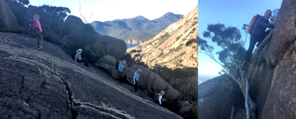
Viewed from the Lake Leake Highway, the peaks of The Hazards can seem like the most impressive feature of the Freycinet National Park, and can certainly be more challenging than those further south on the peninsula proper. Rated hard because of the 800m altitude gained over the distance, but quite achievable by resilient and fit walkers, the walk includes a few very steep granite slabs and a down-climb of a small tree!
Walk Notes:
From Sleepy Bay, the track heads south, ascending steadily and steeply to reach the top of Mt. Parsons (alt. 331m) a little under 2 km from the start. 50m of that altitude is now lost in the gully to the southwest, before a further steep climb in a westerly direction, then some respite before swinging south to gain the summit of Mt. Dove (alt. 485m), the highest point of the traverse. Another 200m is then lost descending steeply southwest into the col before regaining nearly all of that during the equally steep ascent of Mt. Amos (alt. 454m). From there, conditions are much kinder as we descend northwest, then west down a formed track to return to the Freycinet carpark. Total distance is about 6 km.
Please note that if bringing a car, you will need a valid Parks Tasmania pass.
Meeting Times and Places:
If you are interested in going on this walk, please text your walk leader, Kent Lillico, ph. 0428 451 528 to book in. The departure time is 7:00 am from the Door of Hope Church car park, Launceston, but you may also meet the group at the start of the track at Sleepy Bay at 9:20 am. If you would like to arrange to meet the group elsewhere, please arrange with the leader, and please be at any meeting place 5 minutes ahead of the listed time. The leader should always be notified of any other people you intend to bring along, and you should always contact the walk leader if intending to participate in a particular Boots N’ All walk.
To access this area from northern Tasmania: From Launceston, follow the southern outlet and Midland Highway for 70 km to Campbell Town and continue across the Red Bridge to the junction of the Lake Leake Highway (B34) near the southern outskirts of the town. Turn left and follow B34 for 60 km right through to the Tasman Highway (A3) junction. Turn left and head north and then north-east along the Tasman Highway 22 km to reach the Coles Bay Road (C302). Follow Coles Bay Rd for 26 km to reach Coles Bay, and continue through to the Cape Tourville Rd junction, a little under 3 km from the town. The track car park is a further 1.5 km from the road. Total distance 180 km, and allow 2 hours 10 minutes drive time. Further time will be needed for the car shuttle to the Freycinet carpark, about 4 km away, where the walk will end.
Warnings:
The following codes [from our 2024 walks calendar] apply:
S Steep incline for at least part of the way
D Drive distance requires early departure
L A long day’s walk – not so much the distance, but the slow route
C Climbing sections using rocks and vegetation as hand holds.
Please take note of the weather forecast on the day. Make sure you bring drinking water – we suggest 2 litres per person as there is no water on the route. Walkers are advised to wear sturdy boots or strong, high sided sneakers. You should always carry wet weather gear as well as warm clothing in case of sudden weather changes.
Click this link for a more detailed discussion of Preparation, Food and Safety guidelines for Boots N’ All walks.
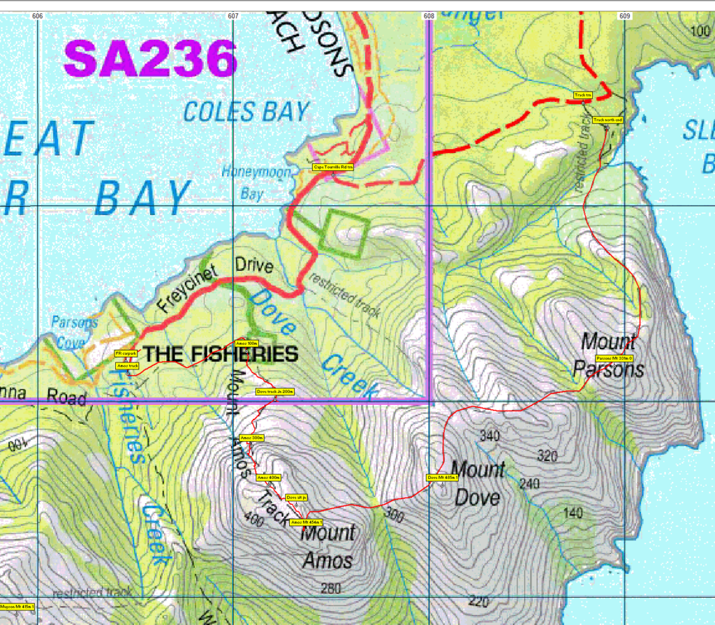
Map details and references:
1:100000 map is Freycinet (Tasmap 8513) and 1:25000 map is Coles Bay (TasMap 6033)
Mt. Parsons:
Zone Easting Northing Latitude Longitude
55G — 6 08 940 — 53 33 150 -42.14620 — 148.31843
Mt Dove:
Short ref. 079324
Zone Easting Northing Latitude Longitude
55G — 6 08 070 — 53 32 570 -42.15154 — 148.30801
Mt Amos:
Short ref. 073322
Zone Easting Northing Latitude Longitude
55G — 6 07 370 — 53 32 340 -42.15371 — 148.29958
Mts Dove and Amos are worth 1 peakbagger points each, as is Mt. Mayson, but the walk is unlikely to extend that far. For listing of peakbagger points, see the Hobart Walking Club Peakbagger’s Guide (2000 revision) which can be downloaded (Excel) from http://tastracks.webs.com/peakbaggers.htm The same web page contains several other listings of Tasmanian peaks.
Downloadable tracks for your navigation devices, including mobile phones: GPX track for this walk ¦ KML track for this walk
Click here to browse our entire collection of walk tracks, including to find GPX (.gpx) and Google Earth (.kml) versions of the track for this walk.
Click here to learn about using your phone as a navigation device, or to find out about handheld GPS devices.