Mt. Murchison Circuit – Sat. 23rd March 2024
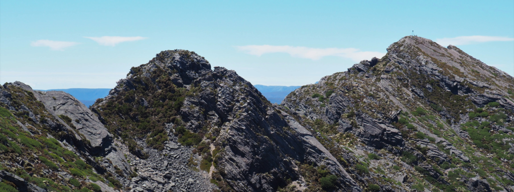
Described by one enthusiast as one of the best day walks in Tasmania, Mt. Murchison has similar rugged grandeur to the better-known Cradle Mountain area, and offers spectacular alpine scenery with extensive views east to the Cradle Mountain area, southeast to the Eldons and Tyndalls, and west towards the Indian Ocean. As one walker describes it, “The 360 degree views from the top are stupendous! Steep climb and challenging bare cliff edge track at places, not a track for faint hearted!” Relatively easy to access (even as a rather long day trip from Launceston), the walk offers enough challenge to satisfy more experienced walkers, but is not beyond fit and energetic older children with some hiking experience in more rugged areas who are able to keep going for sustained distances. Because of the exposed alpine conditions, walkers must be fully prepared for poor weather. Please see the warnings below.
Walk route:
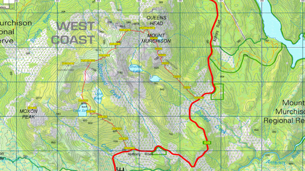
From the Anthony Road, about 5 km south then west of the regular walking track, the route follows an obvious track northwest to Lake Sandra, gaining 350 metres altitude over 1.5km. The next 1.5 km are off-track but following pads up an obvious spur to the north to gain the ridge, a further gain of 300 metres altitude over 2 km to reach 1180 metres. The ridge is open walking and very scenic on the ridge crest, which has a small serrated arete. Heading in a northeasterly direction, a further 2 km will bring you to the spectacular summit. The main track is then followed past a couple of dramatic narrow ledges and descending 700 metres over about 2.5 km southeast to return to the Anthony Road. Total walking distance is about 9 km. A car shuttle is necessary for the circuit.
Because of the long drive from Launceston or southern Tasmania, your leader suggests you might like to camp overnight at Tullah, or book into the Tullah chalet if the budget permits, but please make your own arrangements.
Meeting Times and Places:
If you are interested in going on this walk, please phone or text your walk leader, Darren Wunder on 0438 557 046 to book in. Northwest walkers meet at McDonalds Carpark Burnie, cnr Bass Highway and Wilson Street at 7:30 am.
Because some walkers will likely come from the Launceston area, the main assembly point will be at Tullah. There is a small park with a toilet block at the Wee Georgie Wood Steam Railway, on the left shortly after entering the town.
If coming from Launceston, you may be able to car-pool (negotiate through leader) and meet at Door of Hope. The departure time would need to be 6:30 am to allow for a drive of about 2.5 hours one way via Sheffield and the Cradle Link Road. Please aim to be at Tullah to meet Darren at 8:50 am. Please negotiate any alternative travel arrangements with the leader. You must contact the walk leader per details above if intending to join this walk. Please be at any meeting place 5 minutes ahead of the listed time. The leader must be notified of any other people you intend to bring along.
To access this area from northwest Tasmania:
From Burnie, follow Mount St south (B18), past the outskirts of town where it becomes the Ridgley Hwy (still B18). Continue south through Ridgley and Hampshire to reach Guildford after 54km (about 40 min from Burnie). From Guildford, follow south for about 25 minutes (40km) on Murchison Hwy (A10) to reach Tullah. See below for next part.
To access this area from northern Tasmania: The area can be accessed from several directions, but from Launceston, proceed as if heading for Cradle Mt, the most common route being Bass Hwy past Deloraine to Elizabeth Town, then left into Railton Road, following through to Kimberley. Cross the Mersey R. bridge and turn left into Bridal Track Rd, continuing through to Sheffield. From Sheffield, go south along Claude Rd through Gowrie Park and westward down into the Forth Valley (now Cethana Rd.), continuing up the other side to Moina. Turn south into Cradle Mt. Rd. After approx. 20 km, you will reach the Cradle Mt. turnoff. Do not turn left, but continue a further 27 km or so to reach the Murchison Highway. Continue south about 20 km to reach Tullah.
From Tullah, continue south on Murchison Hwy for about 3 km and turn left into Anthony Rd. The starting point for the Mt. Murchison track is 8.6 km from the turnoff, but this will be the exit point where a vehicle will need to be left. The Lake Sandra track, where the walk will start, is further on – 12.9 km from the Murchison Highway turnoff.
Warnings:
The following codes [from our 2024 walks calendar] apply:
D Drive distance requires early departure
M Marshy or muddy sections – be prepared to walk with wet feet.
S Steep incline for at least part of the way
E Exposed alpine conditions ; can be dangerous in poor weather if not adequately equipped;
Click this link for a more detailed discussion of Preparation, Food and Safety guidelines for Boots N’ All walks, and especially preparation for exposed alpine conditions.
Map details:
Mt. Murchison: 1:100000 map is Sophia (8024) and 1:25000 map is Selina (3836).
Map reference: 851704
Zone Easting Northing Latitude Longitude
55G 3 85 200 53 70 500 -41.80906 145.61796
Mt. Murchison is worth 3 peakbagger points. See The Peakbaggers Points List, which can be downloaded (Excel) from http://tastracks.webs.com/peakbaggers.htm which contains the 1983 and 2000 versions, developed from the original 1968 Hobart Walking Club version. A parallel and more recent but not identical list system is The Abels – also available on the same website, which also contains some other listings of Tasmanian peaks.
For GPX (.gpx) and Google Earth (.kml) versions of the track: Click here to browse our collection.
Direct links: GPX for this walk … KML for this walk
Right-click on the file and save target as to a location of your choice. (Suggest you click the Last modified at top to sort by date to get the most recent at top to find the file for the next walk).